-
current
recommendations- Liefdefjord
New page dedicated to one of Spitsbergen's most beautiful fjords. Background information and many photos.

- New Spitsbergen guidebook
The new edition of my Spitsbergen guidebook is out and available now!
- Liefdefjord
New page dedicated to one of Spitsbergen's most beautiful fjords. Background information and many photos.
-
weather information

| THE Spitsbergen guidebook |
Home →
Yearly Archives: 2014 − News & Stories
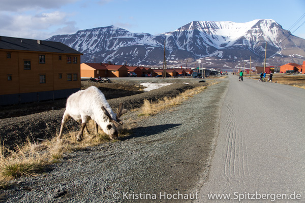
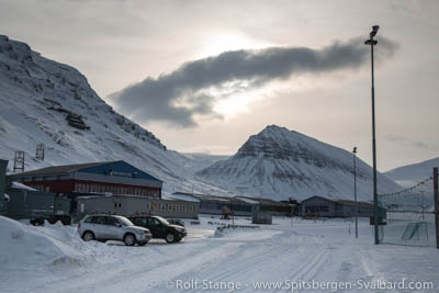
Reindeer killed in traffic accident in Longyearbyen
Traffic in Longyearbyen is usually quite safe, but Monday evening saw a tragic accident when a car hit a reindeer on way 500. The animal’s back was broken, and the police did accordingly not have a choice but to kill the reindeer on the spot.
There are almost always some reindeer somewhere in Longyearbyen, and they are usually not afraid of people or moving vehicles and they don’t watch out for cars before crossing roads. Drivers therefore have to take great care, especially at times of darkness.
Way 500 is the “main street” between the centre and the river. Most streets in Longyearbyen do not have names but numbers.
Reindeer next to the road in Longyearbyen.
Source: Sysselmannen
Polar voyages 2014, 2015: Spitsbergen, Jan Mayen, East Greenland
Most of my polar voyages in 2014 have already been fully booked for quite some time. If you still want to join in 2014, then you have got the possibility to do so in September, focussing on natural history, photography and hiking with SV Antigua. Click here for more info (German site, as the trip is German speaking).
Now I have also got most of the dates for 2015 fixed. Detailed information is yet to come, but as most voyages will, according to experience, be fully booked at an early stage, I do recommend to get in touch in case you are interested.
The following trips in Spitsbergen are planned for 2015 (they will be German speaking, so you should speak a bit if you want to join, but of course it does not have to be your first language):
- Around Spitsbergen with SV Antigua, June 30- July 17, 2015.
- Advanced Spitsbergen: Expedition with SY Arctica II, July 19- August 06, 2015.
- West and North Spitsbergen with Antigua, focussing on glaciers: September 15-25, 2015. Have a look at the photos of a similar voyage in 2012.!
Jan Mayen: our expeditions to Jan Mayen are fully booked more quickly than we can advertise them properly, which is quite amazing! This is the case both for 2014 and 2015, so if you are interested to spend a week on Jan Mayen, then we are now looking at 2016 and you should get in touch sooner rather than later.
We are also planning another trip into Scoresbysund (east Greenland) with SV Ópal, similar to 2013, so have a look at the photos (trip 1 and trip 2) to get an impression. The planning for another trip to East Greenland in 2015 is currently still in an earlier phase.
Sailing expeditions in the arctic: Spitsbergen, Jan Mayen, East Greenland 2015.
February temperatures in Longyearbyen 15 degrees above average
In February, the average temperature was no less than 15 degrees above the long-term average. For weeks, the temperatures have oscillated around freezing. Only the first 10 days, the air was at -10°C or below. Since then, temperate Atlantic airmasses have moved north to push colder, arctic airmasses further away.
Meteorologists have calculated the average temperature of February in Longyearbyen to be -1.2°C. The long-term average for February is -16.2°C.
It can be assumed that it is not only the air that is currently warmer than it used to be, but also the waters around Spitsbergen. The ice situation seems to confirm this, as large parts of the waters east and north of Spitsbergen are far more open than they usually are at this time of the year. Even inner branches of the fjords such as Tempelfjord and Billefjord have not yet really frozen over so far.
The current weather forecast for the next 10 days does at least not show any temperatures above freezing. While it was not far below zero in Longyearbyen over the weekend, temperatures at the east coast were said to be near -30°C.
Also in Norway, the winter has, so far, been far milder than it usually is.
Even the small Adventfjord has not really been frozen in several years by now.
Source: NRK
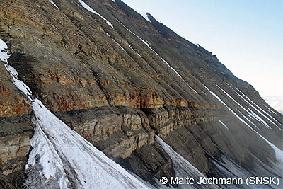
New coal mine at Lunckefjellet officially opened
The mining company Store Norske (SNSK) has opened the new coal mine at Lunckefjellet, between Sveagruva and Reindalen, officially on Tuesday (February 25). Next to miners and company officials, the local adminstration from Longyearbyen and Norwegian media were present at Lunckefjellet. Miner Terje Nyland has cut the symbolic cord to mark the opening. He was determined to do so by lot, rather than an official taking the job, a nice gesture by the mining company.
It is 14 years ago a new coal mine was opened on Svalbard for the last time.
The first ton of coal left Lunckefjellet already on October 25 as part of the preparations for mining, which are now almost finished. Soon, everything is supposed to be ready for a daily production of 10,000 tons coal.
SNSK is currently experiencing economically challenging years. Prices on the world market are under pressure, and the risk connected to exchange rate fluctuations is high. A 1 % loss of the dollar rate may cost the company up to more than 1,2 million Euro. The last time Store Norske has finished a year with a positive result is several years ago. A negative result is expected also for 2014, although the pressure is expected to lessen due to first benefits of the new mine. On the other side, costs for the opening of the Lunckefjellet mine as well as increased costs at Svea Nord, where production is getting into marginal stages, are increasing the pressure.
Store Norske has published the following figures for 2013:
• Production: 1,855,000 tons of coal (2012: 1,229,000)
• Income: 1,32 billion Norwegian Kroner (2012: ca. 160 million)
• Sales: 2,135.000 tons of coal (2012: 701,000 tons)
The economical situation of the new mine at Lunckefjellet, planned to be productive for 6-7 years only, is described as marginal by company leaders already given current market conditions. Store Norske invests in research which is supposed to increase sales prices or generate additional income from, for example, technical upgrading of coal. On the long term, the company has hopes for further new mines near Sveagruva (at the mountain Ispallen) and Longyearbyen (Operafjellet).
New future mines are politically uncertain. People in Longyearbyen are, however, aware that coal mining is still by far the most important single economical factor to support local jobs and accordingly the population of Longyearbyen.
Coal-bearing layers at Lunckefjellet. Foto: Malte Jochmann, SNSK.
Sources: SNSK Bedriftsnytt, Svalbardposten (09/2014)
Russia intensifies military activity in the Arctic
In 2014, Russia wants to intensify its military activity in the Arctic by establishing a new command structure which has the objective to defend Russia´s national interests in this region. This includes the protection of military facilities and civilian ships as well as securing access to the mineral resources on the Arctic shelf.
The new military structure will be called “Northern Fleet – United Strategic Command” (SF-OSK). Its status will be that of a military district, even if this is not officially shown in its name. So far, the Russian military is organized in four large districts: Western, Southern, Central and Eastern.
The main combat force of the SF-OSK will be the Northern Fleet, which is based at the Murmansk region, close to the Norwegian border. It will be withdrawn from the “Western Military District” to form the basis of the new structure. Other units from Northern Russia will be added and new units will be based at Novaya Zemlya, at Franz Josef Land and on the Novosibirsk Islands.
This new strategic orientation of the Russian military must be seen in relation to the exploration of resources in the Arctic during the last years. Estimates tell us that about 30% of the world´s undiscovered gas deposits and 15% of the oil are located on the Arctic shelf. Here, as other countries in this region, Russia defends its economic interests, without making a secret of it. Proposals of putting the Arctic under the control of the international community or to establish protected areas, similar to those in the Antarctic, were unambiguously refused by the Russian President Vladimir Putin in October 2013.
Bukhta Tikhaya, a station on Hooker Island (Ostrov Gukera), Franz Josef Land, abandoned in 1959. In 2014, Russia wants to increase its presence in the area again.
Source: Barentsnova
Retreat of Arctic sea ice accelerates global warming
The retreat of Arctic sea ice acts as an accelerator for climate change, since the bright ice surfaces reflect much more sunlight than the darker surfaces of open water. Ice reflects up to 90% of solar energy back to space while water absorbs a large amount of energy and warms both itself and the overlying air layers.
If warming leads to retreating ice, then this effect causes additional warming and the ice melts even faster: a classical positive feedback reaction. Of course this would also work the other way around: If lower temperatures cause an expansion of snow and ice covered areas, this would lead to an additional cooling.
The ability of surfaces to reflect radiation is expressed by the albedo, a figure that quantifies the amount of reflected radiation in percent.
Scientists of the University of California in San Diego could now, by satellite measuring, verify that the albedo north of the 60. degree of latitude is falling and that this is related to the retreat of arctic sea ice. The result of the measurements is that the albedo decreased from 0,52 to 0,48 between 1979 and 2011. Instead of 52% now only 48% of the solar radiation in the Arctic is reflected. This corresponds to an additional average input of solar energy of ca. 6,4 W/m² since 1979. Averaged over the globe this corresponds to an additional energy input of 0,21 W/m², which is 25% of the amount attributed to the increase of CO2 in the same period.
These figures are significantly higher than those expected before by models and estimates.
Another result of the measuring is the fact that the albedo also decreased in areas which were covered with ice all over the year. One explanation for this is an increasing occurrence of melt water lakes on the ice which again absorb more solar energy and cause additional warming.
Melting fjord ice, Liefdefjord.
Sources: Spiegel Online Wissenschaft, Proceedings of the National Academy of Sciences of the United States of America (PNAS)
Polar night, polar day
Thursday (February 20) the return of the sun at the end of the polar night is celebrated in Barentsburg. Longyearbyen has to wait until March 08, because there are more mountains towards the southern horizon.
A good opportunity for some general thoughs about polar night and polar day. The basic celestial mechanics are generally known: the tilt of the axis of the Earth, which is the reason for polar night and day. Also the so-called Novaya Zemlya effect: the refraction of sunlight in the cold atmosphere, which makes the polar day seemingly (!) longer than it should be, astronomically: the sun is visible even though it is actually just under the horizon, because the sun rays are refracted in the cold atmosphere. This makes a difference of several days and depends on the weather situation. It is called Novaya Zemlya effect because of an early observation of this phenomenon on Novaya Zemlya by Willem Barentsz’ expedition, 1596-97, the same voyage during which Spitsbergen was discovered.
So far so good. But still, the polar night should have the same duration in Arctic and Antarctic on any given latitude, one would expect. But this is not the case. This is a quotation from the South Polar Times, the famous expedition gazette published for the first time during Scott’s first expedition on the Discovery in April 1902. The editor, by the way, was a certain Ernest Shackleton. The following quotation is on page 18: “The South Polar Winter is nearly eight days longer than the North Polar Winter. This is because in the former case, the Earth is farther away from the Sun (aphelion) ,and therefore moves more slowly in its orbit. In the Northern Winter the Earth is closer to the Sun (perihelion) ,and therefore moves more rapidly.” (punctuation as in the South Polar Times, which was typed manually under rather enduring conditions).
The reason is the second of Kepler’s laws of planetary motion: “A line joining a planet and the Sun sweeps out equal areas during equal intervals of time.” In other words: The Earth is moving faster when it is closer to the sun. Simple, isn’t it?
This again means that the Earth spends less time in a position that creates the polar night in the Arctic. On the contrary, the Earth is moving more slowly when further away from the sun, and accordingly spends more time in the position that results in the polar night in the Antarctic.
How big is the difference now? The duration of the polar night is
on 80 degrees north: 122 days (21 Oct – 20 Feb)
on 80 degrees south: 128 days (18 Apr – 24 Aug)
meaning that the difference amounts to six days! The calculations can quite easily be made on a website provided by the US Naval Observatory.
Hut Point, where the South Polar Times was written in 1902 for the first time, is at 77°47’S, 133 nautical miles north of the 80th parallel. The difference of eight days claimed there is accordingly a little bit too much. The value is seven days at the poles.
This is why the polar night is longer in the Antarctic than it is on a corresponding latitude in the Arctic. The answer is Kepler’s second law of planetary motion.
Thanks to Andreas Kaufer for specialist advise and reference to the US Naval Observatory.
The last light of the sun in Barentsburg at the beginning of the polar night, October 22nd.
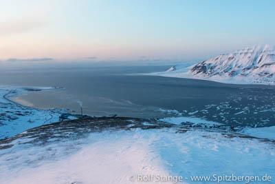
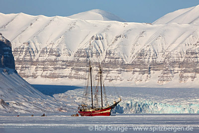
Noorderlicht waiting for the ice in Tempelfjord
In the winter season, the two-mast schooner Noorderlicht freezes into solid ice in Tempelfjord to serve as a destination for tourist activities like snowscooter- and dog sledge tours.
This year the ice is so far missing, so the ship is still waiting its job. Similar to last year, winds from the south are pressing warm water into Isfjord and keep even Tempelfjord still open, which is located at the eastern (innermost) extremity of Isfjord. Another reason are extraordinarily high temperatures in Spitsbergen which have now varied around the freezing point for weeks and make this winter so far one of the warmest since the beginning of the recordings.
Now the tour operators hope for lower temperatures so that the season can start as planned at the end of February when the first tours are scheduled. Last year, the temperatures went down in March and the “boat in the ice” could begin its season just in time.
Noorderlicht in Tempelfjord, April 2013.
Source: Svalbardposten
Decline of population in Longyearbyen
Against a long-term trend, the population in Longyearbyen fell by 47 to the number of 2043 in 2013. This is indicated by the annual report of the Sysselmannen for 2013. As Svalbardposten reports, amongst these 47 there are 17 children in pre-school age, which equals 36%.
Compared to places of similar size on the Norwegian mainland, the number of inhabitants in Longyearbyen can face stronger variations, as those who are registered as residents usually live there for a limited period of time, mostly in accordance to their jobs. Working contracts are temporary, rotations amongst the employees are usual and often desired by employers and many wish to return back home after one season in the arctic. For these reasons, a high fluctuation is quite typical for Longyearbyen.
However, in the last years the number of inhabitants increased permanently. In 2010 there were 1966 people registered in Longyearbyen, in 2011 the number was 2063 and in 2012 it was 2090. Therefore the local government is not concerned about the single decline in 2013, it is not seen as a sign for a long lasting negative trend.
Svalbardposten discusses possible reasons for the current decline of inhabitants: Restructurings at the mining company Store Norske are mentioned, which led to staff reduction. On the other hand the relatively high decline among young children leads to the assumption that many of the new inhabitants came without families. As the reference date for the evaluation of the number of inhabitants is the 31st of December, it is possible that the divergence equalizes again during this year.
In his annual report the Sysselmannen publishes the number of inhbitants for all settlements in Spitsbergen. These are, in addition to Longyearbyen, the settlements of Ny Ålesund (34) and Barentsburg (419), the hotel at Kapp Linné (Isfjord Radio) (1), the four trapper stations Kapp Wijk (1), Akseløya (1), Kapp Schollin (1) and Farmhamna (1) and the polish polar station at Hornsund (10). The workers of the coalmines at Sveagruva, Svea Nord and Lunckefjell, are not registered there, their residences are in Longyearbyen or on the mainland. In 2013 the average number of workers in Sveagruva was 208.
Has currently a few pupils less: school in Longyearbyen.
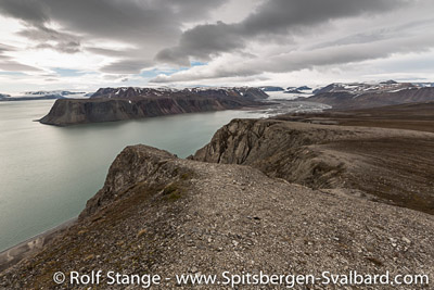
New photo galleries and panoramas from Lomfjord
The light is slowly coming back these days in Spitsbergen after the polar night, but it will take another 2 weeks more or less until the sun makes it above the horizon again. While it is relatively calm in the far north, it is time to get a bit of homework done. There is plenty of material for 360 degree panoramas waiting to be processed, and the pages with regional descriptions on spitsbergen-svalbard.com are to be completed with comprehensive photo galleries from the individual parts of Svalbard.
Both requires significant time and effort, but there is progress. A site that is now complete with galleries and panoramas is the one about Lomfjord in northeastern Spitsbergen, neighbouring Hinlopen Strait.
If you prefer to see the panoramas and photo galleries separately, without all the talking about geology and history, then check these two dedicated sites: photo galleries and panoramas.
These sites are just part of a major development that is aiming at a comprehensive illustration of all parts of the Spitsbergen archipelago (and Jan Mayen and parts of Greenland and Antarctica, for that sake) with photo galleries and navigable 360 degree panorama material. This requires a lot of effort in terms of both time and money. The results are on spitsbergen-svalbard.com and can be freely accessed at no cost and without registration or whatever, but the website and its owner/maker are happy about links or like it clicks. If you want to support these efforts financially, then please have a look on the right side if there is any book or calendar that might fit well into your collection or as a present …
View over Lomfjord, which has now got a comprehensive site complete with photo gallery and 360 degree panos.
Svalbard environmental protection act updated
The Svalbard environmental protection act (Svalbardmiljøloven) regulates what can and what can’t be done in Spitsbergen’s nature. It is updated more or less regularly to meet the latest needs. The latest update came into force with the arrival of 2014. There are no major changes relevant for most visitors/tourists.
Changes include:
• Longyearbyen’s council area has been enlarged to include Adventfjord completely. This means that this area is now administrated locally by the elected municipal administration of Longyearbyen and not centrally from Oslo through the appointed Sysselmannen (governor), as all other areas of Spitsbergen which are not part of any council area of the settlements.
• Minor adjustments have been made in the regulations for hunting. So far, young hunters had to be at least 16 years old. Now, it is enough to celebrate one’s 16th birthday in the calendar year in question. This will certainly be very popular in Longyearbyen, where children are introduced to hunting already in the Kindergarten.
• The use of marine hovercraft, already forbidden on land and frozen lakes and rivers, is now also banned from the sea within one mile off shore. The use of such crafts has been matter of controversial debate in Spitsbergen recently. They have been used for research, including expeditions far out into the Arctic Ocean, and locally in Sveagruva for Search and Rescue (SAR) preparedness. Large wet areas near Sveagruva are neither accessible by boat nor by land vehicle, but SAR forces need to be able to reach these areas in case of accidents. There is a small airstrip in Sveagruva. The use of hovercraft remains possible in case of emergencies, but currently not for the purpose of practice. It is not unlikely that SAR forces in Sveagruva will get some more freedom here to enable them to practice with hovercraft. Commercial use of hovercrafts, for example within filming our tourism, has not been an issue so far and is not an option anymore from now on.
• The so-called administration area 10, where visitors can move around without notifying the Sysselmannen in advance, has been enlarge around Ny Ålesund, giving people there more freedom to move around also privately. Most scientists in Ny Ålesund don’t stay long enough to get legal status as residents, so they are as restricted as any other tourist for their private trips. The area they can access without notifying the Sysselmannen now also includes the famous mountains Tre Kroner and a larger part of Forlandsund.
Adventfjord seen from Sukkertoppen near Longyearbyen. This area is now under local administration.

Source: Norwegisches Klima und Umweltministerium, Pressemitteilung
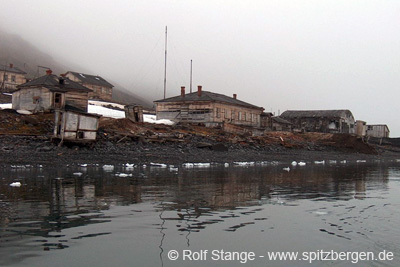
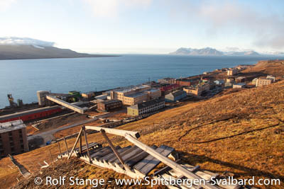
Barentsburg: coal mine re-opens after accidents in 2013
Coal production can now start to continue in the Russian mine in Barentsburg. In 2013, workers were killed or injured in a series of 3 serious accidents, after which Norwegian authorities fined the Russian mining company with NOK 1.3 million (about Euro 155,000) and closed the mine temporarily. In April 2013, one miner was killed in a block fall. In June, one was killed by falling stones and in September, one lost a leg after another accident. The mine was subsequently closed due to the generally low safety level.
Since then, the Trust has followed Norwegian advice to increase the safety in the mine. Now, the Norwegians have got the impression that the situation is improving and have given permission to re-open the mine.
Coal production was already stopped in Barentsburg in 2008 after a fire in the mine fore more than 2 years.
Barentsburg: coal mine permitted to re-open after accidents in 2013.
Source: Barentsobserver
Hopen: discoverer Marmaduke finally on the map
The little island Hopen in southeastern Svalbard was, as far as known, discovered in 1613 by the English whaler Thomas Marmaduke. The island was subsequently named after his ship, the Hopewell, but the name of the discoverer did not make it on the map.
This scandal has caught the attention of the crew of the Norwegian weather on Hopen, who decided, in the year of the 400th anniversary of the discovery, to file a request to the Norwegian Polar Institute (NPI) to get something done about it. It was the station cook who sent the application, and an appropriate, as so far nameless, topographic feature was duly found: a little gully on the west side of the island, just a few hundred metres from the station. The name giving committee of the NPI agreed, and the gully in question bears now officially the name Marmadukeskaret (Marmaduke gully).
The name giving committee meets twice every year to decide officially about new place names which then appear on the topographic map. Basically, everybody can file suggestions. Names of living persons have, however, hardly any chance to be accepted.
Gully on the island Hopen. Not the one now named after Marmaduke, but that one is quite similar. A bit smaller.
Source: Hopenmeteo
Arctic aliens: mitigating invasive species
The introduction of new species to isolated ecosystems with a low species diversity is always problematic and often catastrophic, as anyone know who is following the development on sub-antarctic islands such as South Georgia. In the Arctic, the problem is at least a bit less dramatic than on sub-antarctic islands. There are several reasons: flora and fauna are already to some degree adapted to plant-eating animals and predators, respectively. Secondly, the natural introduction of new species by winds and currents is much more common in the Arctic, which is a main reason why it has much more animal and plant species than remote islands in the deep south, where latitudinal winds and currents isolate them rather than connecting them to warmer areas.
But the problem of invasive species is nevertheless to be taken very seriously also in the high north. There is already a number of alien species in Spitsbergen, which has a long history of exploration, mining etc., during which plants and animals were imported with building materials, animal feed and other cargo. Species that might be especially problematic for the natural diversity of species include cow parsley (Anthriscus sylvestris), which is thriving in Barentsburg, and the southern vole (Microtus levis). The fact that the southern vole lives happily in places like Grumantbyen and Colesbukta, which have been abandoned as mining settlements half a century ago, indicates that not much may be needed in terms of adaptation or climate warming to make it spread over large areas so far unaffected.
Now the local administration (Sysselmannen) has decided to do something about it. This has taken surprisingly long, considering what can be learnt from efforts to remove invasive species from sub-antarctic islands.
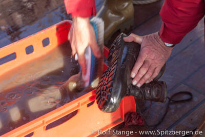
The need to prevent new invasive species from coming to Spitsbergen is evident. Cargo and ballast water of ships will need attention to achieve this. Also, studies have shown that a surprising amount of seeds and organic material comes attached to boots of flight passengers arriving Longyearbyen. As a consequence, the governor will request future visitors to make sure they do not transport unwanted organic materials by accident. This is already common practice in Antarctica.
Attempts should also be made to remove invasive species that are already there. If this is not possible, then their further dispersal should be controlled.
To start this process, the Sysselmannen has now published a report to describe the problem and to identify appropriate measures.
Simple, but effective: clean your boots!
Source: Sysselmannen
Arctic invadors: the Snow Crab in the Barents Sea
The introduction of new species to ecosystems, be it by natural migration, with human influence or helped by climate change, is hardly ever good news for any region affected. Too often, locally established species suffer severely from their new neighbours. This is especially the case for relatively isolated ecosystems, for example in polar areas or on remote islands.
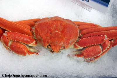
There is a new species now established in the Barents Sea: the Snow Crab (Chionoecetes opilio), which can be up to 90 cm large (including the legs) and 2 kg heavy. She was wide-spread also in the past, with an occurrence in the Bering Strait and further north as well as at the coasts of Newfoundland. It is likely that it has migrated along the coast of Siberia westwards into the Barents Sea. Initially, it was found east of the Barents Sea, near Novaya Zemlya, but it has been reported east of Spitsbergen since.
Experience in a similar case, with King Crabs at the coast of North Norway, has shown that the marine bottom fauna is strongly depleted by their new hungry neighbours. It is likely that the Snow Crab has a similarly healthy appetite as its relative, the King Crab. Additionally, it may just be a question of time until the King Crab itself migrates further north to inhabit the northern Barents Sea and Svalbard waters.
The Snow Crab has been found east of Spitsbergen since the mid 1990s and is now about to become a precious target species for the fishing industry.
Immigrants to the Barents Sea: Snow Crab (foto © Terje Engø).
Source: Kystmagasinet
News-Listing live generated at 2024/April/25 at 06:48:14 Uhr (GMT+1)


-
Books, Calendar, Postcards and more

-


