-
current
recommendations- Liefdefjord
New page dedicated to one of Spitsbergen's most beautiful fjords. Background information and many photos.

- New Spitsbergen guidebook
The new edition of my Spitsbergen guidebook is out and available now!
- Liefdefjord
New page dedicated to one of Spitsbergen's most beautiful fjords. Background information and many photos.
-
weather information

| THE Spitsbergen guidebook |
Home →
Daily Archives: 6. January 2016 − News & Stories
Looking back at 2015 – August
I was on the sailing yacht Arctica II when July left and August came. This summer was unusually ice-rich in Svalbard, so we expected to be unable to circumnavigate Spitsbergen, something that had not been the case for several years. But who would complain about too much ice in the arctic? Usually, we are moaning about the opposite these days.
Crossing Prins Karls Forland from west to east is not quite like crossing Greenland. It can easily be done as a day hike. But how often do you have the opportunity? The sea calm enough to go ashore on the exposed outer side? The weather good enough to make it really enjoyable? Everything worked out well and we all thoroughly enjoyed the stunning views over Prins Karls Forland and the adjacent seas and mountains.
Something that crosses my mind when I think back of this trip is the days that we spent in the ice in the southeast. The combination of ice and current in Heleysund was indeed spectacular and something one would not necessarily want to do every day. Having done that, we considered the circumnavigation a fact and I was happy to get to Barentsøya and Edgeøya. A summer without getting to these islands in southeastern Svalbard would not be quite complete.
Not quite complete as of yet was our circumnavigation, as it turned out. The ice in southern Storfjord actually almost made us doubt it would happen at all, but after spending some time looking for a passage, the strong Hurtigruten ship Fram suddenly came, pushed into the ice, thus creating a channel that we could use comfortably.
- gallery anchor link: #gallery_847
Click on thumbnail to open an enlarged version of the specific photo.


While were were circumnavigating Spitsbergen not without some effort, some brave adventurers went around Nordaustland – in sea kayaks! Actually, two teams did this almost simultaneously. For one of them, it was just a part of a pretty extreme trip from and to Longyearbyen. This was one of the last big „firsts“ to be had in Svalbard. Congratulations!
Avalanche in Longyearbyen: evacuation lifted
The weather in Longyearbyen is finally settling with temperatures below zero and little wind, so authorities could now lift the evacuations and general ban on any traffic in areas on the eastern side of the settlement. People are free to return to their homes since Tuesday evening, 2000.
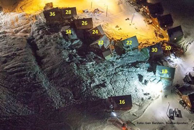
The catastrophic avalanche before Christmas, which destroyed 11 houses and killed two people, was followed by an evacuation of a total of 114 flats. Consequently, about 200 people had to leave their homes, near 10 % of the total population. The exact number is unknown, as not everybody concerned reported to the authorities. Some are also, as is quite common, on Christmas holidays, following the events from warm beaches far away.
At the same time, the avalanche hazard for parts of Longyearbyen is highlighted by authorities. This risk had been known for a long time, but now it has brutally come to everybody’s minds, finally. A preliminary system with actual avalanche risk evaluation has been installed on varsom.no, as has been commonly used in mainland Norway for some time already. Ways to deal with the risk locally will be discussed now. Areas at risk will be mapped and then measures from technical safety means to – potentially – permanent evacuation of some areas will considered. The local community administration (Lokalstyre) is responsible, in cooperation with relevant technical authorities.
The lack of safety measures, a warning system and public awareness, also within the authorities, has received criticism, as the risk had been known for many years. Longyearbyen will see a debate about responsibility.
The relevant part of Longyearbyen before the avalanche (image © Norwegian Polar Institute).
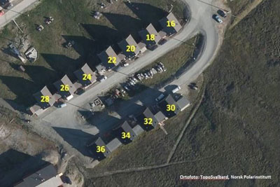
The relevant part of Longyearbyen after the avalanche. Houses can be identified in both images by the numbers. Buildings have been moved up to 80 metres (photo © Geir Barstein/Svalbardposten).
Source: Sysselmannen
News-Listing live generated at 2024/April/16 at 22:50:03 Uhr (GMT+1)


-
Books, Calendar, Postcards and more

-


