-
current
recommendations- Liefdefjord
New page dedicated to one of Spitsbergen's most beautiful fjords. Background information and many photos.

- New Spitsbergen guidebook
The new edition of my Spitsbergen guidebook is out and available now!

- Liefdefjord
New page dedicated to one of Spitsbergen's most beautiful fjords. Background information and many photos.
-
weather information

| THE Spitsbergen guidebook |
Danmark Ø
360°-Panoramas
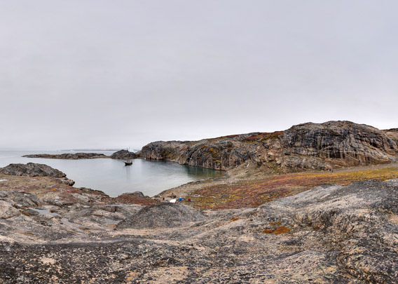
Danmark Ø („Denmark Island“, greenlandic: Ujuaakajiip Nunaa) lies on the southern side of Milne Land at a fjord crossing. To the east is Hall Bredning, the wide-open middle part of Scoresbysund. To the south is the opening of Gåsefjord and Fønfjord, the windy waterway into innermost Scoresbysund, starts directly west of Danmark Ø.
Danmark Ø is a roughly square-shaped island, more than 15 km across and with many rocky hills up to 380 m high. The glacial origin of the landforms is pretty obvious, some slopes are very steep, but the hills of ancient gneiss are mostly rounded and spread erratic boulders make the origin of these landforms very clear.
There is a small, shallow but well-sheltered bay at the southern tip of the island called Hekla Havn. It provides good anchorage for small boats and yachts. It was here that the ship Hekla of Carl Ryder’s Østgrønlandske Expedition wintered in 1891-92, and on this occasion, both the island and the bay got their names.
During good weather, which is not uncommon in inner Scoresbysund, the views from the hills of Danmark Ø to the landscape in near and far distance are really great. The difference between the gneiss landscapes to the north and the basalt country to the south are obvious even for the untrained observer. The basalt shows clear stratification, which the older gneiss does not have (not because it is older, but because it is a completely different kind of rock). The transition is nicely visible at Gåseland (the peninsula between Fønfjord and Gåsefjord), as you look southwest from Danmark Ø, where the older and accordingly deeper seated gneiss is covered by basalt layers. Further south, the gneiss disappears below sea level. On Danmark Ø, you can admire the gneiss, the ancient geological basement of this region, from close distance with all its beautiful little features, from foliation to small dark intrusions and amphibolite lenses (old, deformed basaltic intrusions).
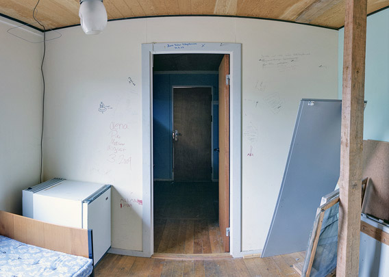
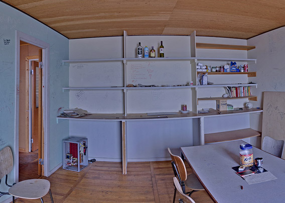
During a visit in September 2013, when I made these panoramas, the weather was less favourable, and the views and photos taken on that day don’t do the usual splendor of the scenery justice. Well, next time! But for the time being, there are some inside panoramas of the spacious hut at Hekla Havn, which is still often used by local hunters and expeditionists from elsewhere.
Panoramas
- pano anchor link: #Hekla-Havn_09Sept13_038
Vagn Bjerre Christensen
20/7-24/8 Geodätisk Institut 1954
13/7-23/7 Watkins Mountains Expedition 1969
22/7-24/7 Travel Life 2004
Bygget Stationen Heklahavn 01.08-25.08.1967
Niels Johannes Jacobsen / Tømrer · Bjørge Nielsen / -II-
Leif Sørensen / Mekaniker · Svend Erik Worm / Lærer
Assisteret af:
Jonas Brønlund / Ex. Mand · Boas Arke / -II- · Villy Kristensen / Bådsmand
Erich Flintsteiner (?) / Ing.
NORDISK MINESELSKAB A/S
- pano anchor link: #Hekla-Havn_09Sept13_060
In diesem Raum haben sich neben zahlreichen Einheimischen u.a. der alte Grönlandfahrer Peter Fabel mit Begleitern (2006) sowie ein Team des NDR-TV/Nordsee-Report mit Peter von Sassen und weiteren (August 2006) verewigt.
- pano anchor link: #Hekla-Havn_09Sept13_090
BOOKS, CALENDAR, POSTCARDS AND MORE
This and other publishing products of the Spitsbergen publishing house in the Spitsbergen-Shop.
-

Norwegens arktischer Norden (1): Spitzbergen
Photobook: Norway's arctic islands. The text in this book is German. [shop url="https://shop.spitzbergen.de/en/polar-books/70-norwegens-arktischer-norden-1-aerial-arctic-9783937903262.html"] ← BackOrder now -

Norwegens arktischer Norden (2): Aerial Arctic
Lofoten, Jan Mayen and Spitsbergen from the air - Photobook: Norway's arctic islands. The text in this book is German, but there is very little text, so I am sure that you will enjoy it regardless which languages you read (or not).Order now -

Poster “Svalbardhytter”
The poster "Svalbardhytter" (70 x 100 cm) visualizes the diversity of Spitsbergen's huts in a range of arctic landscapes.Order now -

Book “Svalbardhytter”
The companion book for the Svalbardhytter poster. The poster visualises the diversity of Spitsbergen‘s huts and their stories in a range of Arctic landscapes. The book tells the stories of the huts in three languages.Order now -

Spitsbergen – Svalbard. The complete guidebook
Comprehensive guidebook about Spitsbergen. Background (wildlife, plants, geology, history etc.), practical information including travelling seasons, how to travel, description of settlements, routes and regions.Order now -

Rocks and Ice. Landscapes of the North
A geographical traveling accompaniment to Spitsbergen and East Greenland (68-74°N). This is the English edition of the German book "Steine und Eis".Order now -

East Greenland in Winter
Join an exciting journey with dog, skis and tent through the wintery wastes of East Greenland! We were five guys and a dog when we started in Ittoqqortoormiit, the northernmost one of two settlements on Greenland’s east coast.Order now -

Postcard set Spitsbergen (Svalbard)
12 Spitsbergen postcards in a beautifully designed tray. Individually numbered limited edition!Order now -

Limited edition postcard set Antarctica
12 postcards which come in a beautifully designed tray. Beautiful images from South Georgia across Antarctica from the Antarctic Peninsula to the Ross Sea and up to Macquarie Island and Campbell Island.Order now
last modification: 2014-01-04 ·
copyright: Rolf Stange
-
Books, Calendar, Postcards and more

-


