-
current
recommendations- Liefdefjord
New page dedicated to one of Spitsbergen's most beautiful fjords. Background information and many photos.

- New Spitsbergen guidebook
The new edition of my Spitsbergen guidebook is out and available now!

- Liefdefjord
New page dedicated to one of Spitsbergen's most beautiful fjords. Background information and many photos.
-
weather information

| THE Spitsbergen guidebook |
Home → * Photos, Panoramas, Videos and Webcams → Spitsbergen Panoramas → Blomstrandhalvøya: Bratliekollen
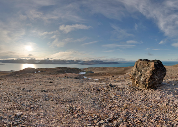
Blomstrandhalvøya: Bratliekollen
360° panorama
Bratliekollen is 370 metres high, which makes it the second-highest “mountain” on Blomstrandhalvøya in Kongsfjord. The height may not be impressive, but the 360 degree panorama view of the surrounding Kongsfjord certainly is. Also Ny-Ålesund is visible from here, Spitsbergen’s northermmost settlement. The landscape bears strong character of former glaciation such as many large erratic boulders and rounded hills, clear traces of the ice age rather than recent glaciation. The higher parts of Blomstrandhalvøya have well-developed solifluction areas (can be pretty muddy!) and frost-patterned ground.
Geologically, Blomstrandhalvøya consists largely of pre-cambrian marble, which was exploited in the early 20th century on a trial basis by the Northern Exploration Company in their marble mine Marble Island, which is today mostly known as Ny London. Next to Marble Island, Blomstrandhalvøya is, at least amongst geologists, known for the grottos and caves.
Pano 1 – Blomstrandhalvøya: Bratliekollen
- pano anchor link: #190921d_Brattlikollen_10HDR
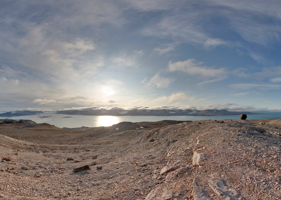
Bratliekollen was named after Jens Kristian Meinich Bratlie (1856-1939), a Norwegian politician. “Kollen” means hill.
The highest elevation on Blomstrandhalvøya is Irgensfellet.
Pano 2 – Blomstrandhalvøya: Bratliekollen
- pano anchor link: #190921d_Brattlikollen_29HDR
BOOKS, CALENDAR, POSTCARDS AND MORE
This and other publishing products of the Spitsbergen publishing house in the Spitsbergen-Shop.
-

Norwegens arktischer Norden (1): Spitzbergen
Photobook: Norway's arctic islands. The text in this book is German. [shop url="https://shop.spitzbergen.de/en/polar-books/70-norwegens-arktischer-norden-1-aerial-arctic-9783937903262.html"] ← BackOrder now -

Norwegens arktischer Norden (2): Aerial Arctic
Lofoten, Jan Mayen and Spitsbergen from the air - Photobook: Norway's arctic islands. The text in this book is German, but there is very little text, so I am sure that you will enjoy it regardless which languages you read (or not).Order now -

Poster “Svalbardhytter”
The poster "Svalbardhytter" (70 x 100 cm) visualizes the diversity of Spitsbergen's huts in a range of arctic landscapes.Order now -

Book “Svalbardhytter”
The companion book for the Svalbardhytter poster. The poster visualises the diversity of Spitsbergen‘s huts and their stories in a range of Arctic landscapes. The book tells the stories of the huts in three languages.Order now -

Spitsbergen – Svalbard. The complete guidebook
Comprehensive guidebook about Spitsbergen. Background (wildlife, plants, geology, history etc.), practical information including travelling seasons, how to travel, description of settlements, routes and regions.Order now -

Rocks and Ice. Landscapes of the North
A geographical traveling accompaniment to Spitsbergen and East Greenland (68-74°N). This is the English edition of the German book "Steine und Eis".Order now -

East Greenland in Winter
Join an exciting journey with dog, skis and tent through the wintery wastes of East Greenland! We were five guys and a dog when we started in Ittoqqortoormiit, the northernmost one of two settlements on Greenland’s east coast.Order now -

Postcard set Spitsbergen (Svalbard)
12 Spitsbergen postcards in a beautifully designed tray. Individually numbered limited edition!Order now -

Limited edition postcard set Antarctica
12 postcards which come in a beautifully designed tray. Beautiful images from South Georgia across Antarctica from the Antarctic Peninsula to the Ross Sea and up to Macquarie Island and Campbell Island.Order now
last modification: 2019-10-10 ·
copyright: Rolf Stange
-
Books, Calendar, Postcards and more

-


