-
current
recommendations- Liefdefjord
New page dedicated to one of Spitsbergen's most beautiful fjords. Background information and many photos.

- New Spitsbergen guidebook
The new edition of my Spitsbergen guidebook is out and available now!

- Liefdefjord
New page dedicated to one of Spitsbergen's most beautiful fjords. Background information and many photos.
-
weather information

| THE Spitsbergen guidebook |
Rossøya
360 degree panorama of Svalbard's northernmost island
The Sjuøyane (“Seven Islands”) are the northern most outliers of Svalbard, and the little island of Rossøya is the very northernmost one. There is no land further north in this part of the Arctic, just water.
Rossøya – Pano 1
- pano anchor link: #170805a_Rossoya_081HDR
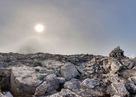
Rossøya lies without any shelter on the edge of the Arctic Ocean. It is actually just a skerry, just a large, steep rock. Its shape looks like the back of a turtle from the distance. Nobody would pay any attention to Rossøya if it was not the northernmost island. It has to be said, though, that there are islands and land further north in other parts of the Arctic, such as Frans Josef Land (Russia) and Greenland. The latter goes up to almost 84 degrees north. Here on Rossøya, we are at 80°49.7’N/20°20.8’E.
Rossøya – Pano 2
- pano anchor link: #170805a_Rossoya_317HDR
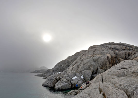
Rossøya does not make it easy for visitors. The sea has to be flatcalm, otherwise one should stay away from this steep, rocky and completely exposed coast. There might be ice, fog or polar bears, and none of these factors is good for landings, let alone a combination of several ones. And once you have managed to put your feet on solid ground (good old crystalline basement rock), there is a bit of a climb waiting in case you want to get up to the top, something that will not be everybodies cup of tea.
Rossøya – Pano 3
- pano anchor link: #170805a_Rossoya_112HDR

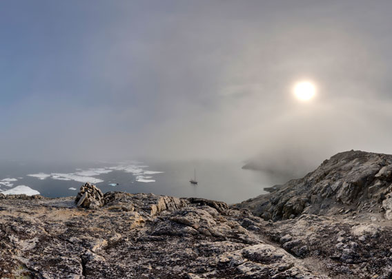
There were a few icefloes around and a little bit of fog, just enough to add to the atmosphere as we took the rare opportunity to climb up to the top of Rossøya. To the south, just under the sun, we can vaguely see Vesle Tavleøya, Rossøya’s southern neighbour, which is a bit larger and steeper. There are even puffins breeding on the cliffs there, almost on 81 degrees north!
The sun is painting a halo into the fog banks to the north.
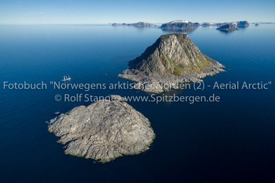
For orientation, an aerial photograph from by book Norwegens arktischer Norden (2): Aerial Arctic. Rossøya in the front, then Vesle Tavleøya. The rest of the Sjuøyane in the background, Nordaustland in the far distance. More photos like that in the book 😉
Up there it was – rocky. Who would have expected anything else?
Rossøya – Pano 4
- pano anchor link: #170805a_Rossoya_143HDR
There are some lichens and Svalbard’s northernmost breeding bird is very likely the Skua that has a nest on top of Rossøya. There are three solid cairns, probably built by Swedish 19th century explorers and scientists such as the famous Adolf Erik Nordenskiöld (yes, the one with the northeast passage) and the Russian-Swedish Arc de Meridian expedition that did splendid work in Spitsbergen between 1899 and 1902.
Rossøya photo gallery
Finally some more photos with impressions from Rossøya, giving an idea of the island’s landscape, structure, geology and vegetation.
- gallery anchor link: #gallery_2175
Click on thumbnail to open an enlarged version of the specific photo.


BOOKS, CALENDAR, POSTCARDS AND MORE
This and other publishing products of the Spitsbergen publishing house in the Spitsbergen-Shop.
-

Norwegens arktischer Norden (1): Spitzbergen
Photobook: Norway's arctic islands. The text in this book is German. [shop url="https://shop.spitzbergen.de/en/polar-books/70-norwegens-arktischer-norden-1-aerial-arctic-9783937903262.html"] ← BackOrder now -

Norwegens arktischer Norden (2): Aerial Arctic
Lofoten, Jan Mayen and Spitsbergen from the air - Photobook: Norway's arctic islands. The text in this book is German, but there is very little text, so I am sure that you will enjoy it regardless which languages you read (or not).Order now -

Poster “Svalbardhytter”
The poster "Svalbardhytter" (70 x 100 cm) visualizes the diversity of Spitsbergen's huts in a range of arctic landscapes.Order now -

Book “Svalbardhytter”
The companion book for the Svalbardhytter poster. The poster visualises the diversity of Spitsbergen‘s huts and their stories in a range of Arctic landscapes. The book tells the stories of the huts in three languages.Order now -

Spitsbergen – Svalbard. The complete guidebook
Comprehensive guidebook about Spitsbergen. Background (wildlife, plants, geology, history etc.), practical information including travelling seasons, how to travel, description of settlements, routes and regions.Order now -

Rocks and Ice. Landscapes of the North
A geographical traveling accompaniment to Spitsbergen and East Greenland (68-74°N). This is the English edition of the German book "Steine und Eis".Order now -

East Greenland in Winter
Join an exciting journey with dog, skis and tent through the wintery wastes of East Greenland! We were five guys and a dog when we started in Ittoqqortoormiit, the northernmost one of two settlements on Greenland’s east coast.Order now -

Postcard set Spitsbergen (Svalbard)
12 Spitsbergen postcards in a beautifully designed tray. Individually numbered limited edition!Order now -

Limited edition postcard set Antarctica
12 postcards which come in a beautifully designed tray. Beautiful images from South Georgia across Antarctica from the Antarctic Peninsula to the Ross Sea and up to Macquarie Island and Campbell Island.Order now
last modification: 2022-02-05 ·
copyright: Rolf Stange
-
Books, Calendar, Postcards and more

-


