


-
current
recommendations- Liefdefjord
New page dedicated to one of Spitsbergen's most beautiful fjords. Background information and many photos.

- New Spitsbergen guidebook
The new edition of my Spitsbergen guidebook is out and available now!
- Liefdefjord
New page dedicated to one of Spitsbergen's most beautiful fjords. Background information and many photos.
-
weather information

| Guidebook: Spitsbergen-Svalbard |
Bear Island (28 June - 06 July 2010)
Everybody is travelling to small islands somewhere south during his holidays. So did I 😄 for a week, I went to Bear Island (Bjørnøya), situated half-way between the north cape of Norway and the south cape of Spitsbergen. Maybe not exactly what most people would consider “the south”, but a great and highly interesting place, if you ask me.
I went forth and back over most of the island, following the coastline from the weather station in the north to the spectacular cliffs and seabird colonies in the south.
Some images:
bjornoya (gallery)
- gallery anchor link: #gallery_147
Click on thumbnail to open an enlarged version of the specific photo.


Many thanks to …
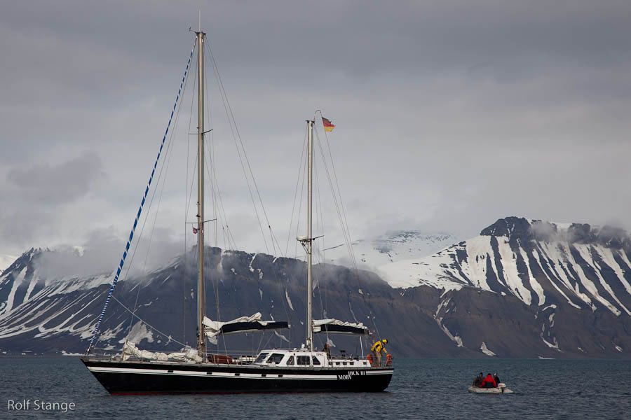
»Moby Dick III« (Gernsheimer Hochseekameradschaft)
»Brigantia«
(GfS=Gemeinschaft für Seefahrt e.V.)

… for getting me there and back again!
As well as to the crew of the weather staion …

… and, last but not least, a relatively friendly weather God.
 weather")
Map
 map")
BOOKS, CALENDAR, POSTCARDS AND MORE
This and other publishing products of the Spitsbergen publishing house in the Spitsbergen-Shop.
-

Norwegens arktischer Norden (1): Spitzbergen
Photobook: Norway's arctic islands. The text in this book is German. [shop url="https://shop.spitzbergen.de/en/polar-books/70-norwegens-arktischer-norden-1-aerial-arctic-9783937903262.html"] ← BackOrder now -
Norwegens arktischer Norden (2): Aerial Arctic
Lofoten, Jan Mayen and Spitsbergen from the air - Photobook: Norway's arctic islands. The text in this book is German, but there is very little text, so I am sure that you will enjoy it regardless which languages you read (or not).Order now -
Poster “Svalbardhytter”
The poster "Svalbardhytter" (70 x 100 cm) visualizes the diversity of Spitsbergen's huts in a range of arctic landscapes.Order now -
Book “Svalbardhytter”
The companion book for the Svalbardhytter poster. The poster visualises the diversity of Spitsbergen‘s huts and their stories in a range of Arctic landscapes. The book tells the stories of the huts in three languages.Order now -
Spitsbergen – Svalbard. The complete guidebook
Comprehensive guidebook about Spitsbergen. Background (wildlife, plants, geology, history etc.), practical information including travelling seasons, how to travel, description of settlements, routes and regions.Order now -
Rocks and Ice. Landscapes of the North
A geographical traveling accompaniment to Spitsbergen and East Greenland (68-74°N). This is the English edition of the German book "Steine und Eis".Order now -
East Greenland in Winter
Join an exciting journey with dog, skis and tent through the wintery wastes of East Greenland! We were five guys and a dog when we started in Ittoqqortoormiit, the northernmost one of two settlements on Greenland’s east coast.Order now -
Postcard set Spitsbergen (Svalbard)
12 Spitsbergen postcards in a beautifully designed tray. Individually numbered limited edition!Order now -
Limited edition postcard set Antarctica
12 postcards which come in a beautifully designed tray. Beautiful images from South Georgia across Antarctica from the Antarctic Peninsula to the Ross Sea and up to Macquarie Island and Campbell Island.Order now
last modification: 2025-02-01 ·
copyright: Rolf Stange


-
Books, Calendar, Postcards and more

-


