


-
current
recommendations- Liefdefjord
New page dedicated to one of Spitsbergen's most beautiful fjords. Background information and many photos.

- New Spitsbergen guidebook
The new edition of my Spitsbergen guidebook is out and available now!
- Liefdefjord
New page dedicated to one of Spitsbergen's most beautiful fjords. Background information and many photos.
-
weather information

| Guidebook: Spitsbergen-Svalbard |
Home
→ * Photos, Panoramas, Videos and Webcams
→ Spitsbergen Panoramas
→ Grunnvågen & Kikutodden
Sørkapp Land: Grunnvågen & Kikutodden
360° panorama
Sørkapp Land
Grunnvågen and Kikutodden are located in Sørkapp Land close to the southernmost point of the main island Spitsbergen. As the name Grunnvågen (“Shallow bay”) suggests, the coastal waters are shallow far out into the sea, and they are poorly charted. Even smaller boats like SV Antigua have to keep a distance of a nautical mile or so, and it is a long Zodiac ride to the shore. A large, open bay like Grunnvågen does not provide any shelter at all, so it not a good idea to attempt a landing here unless the weather conditions are really perfect.
Grunnvågen
- pano anchor link: #170630a_Grunnvagen_01HDR
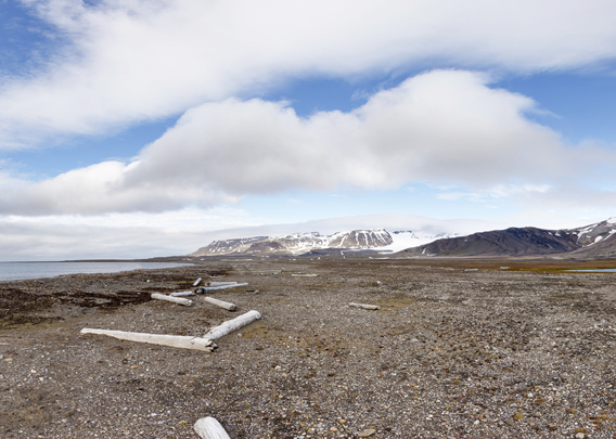
Those few visitors who may nevertheless get here will find a wide-open coastal plain with small creeks and wetland areas with green moss patches in an otherwise rather barren tundra area. Pieces of driftwood and the occasional whalebone are lying on the beach.
Kikutodden
On the eastern end of the bay Grunnvågen, there is a small, rocky peninsula called Kikutodden (“View point”). Kikutodden is composed of steeply dipping layers of hard sediment. These are continued under water, forming a large number of rocky reefs in this area.
- pano anchor link: #170630a_Grunnvagen_102HDR

BOOKS, CALENDAR, POSTCARDS AND MORE
This and other publishing products of the Spitsbergen publishing house in the Spitsbergen-Shop.
-

Norwegens arktischer Norden (1): Spitzbergen
Photobook: Norway's arctic islands. The text in this book is German. [shop url="https://shop.spitzbergen.de/en/polar-books/70-norwegens-arktischer-norden-1-aerial-arctic-9783937903262.html"] ← BackOrder now -
Norwegens arktischer Norden (2): Aerial Arctic
Lofoten, Jan Mayen and Spitsbergen from the air - Photobook: Norway's arctic islands. The text in this book is German, but there is very little text, so I am sure that you will enjoy it regardless which languages you read (or not).Order now -
Poster “Svalbardhytter”
The poster "Svalbardhytter" (70 x 100 cm) visualizes the diversity of Spitsbergen's huts in a range of arctic landscapes.Order now -
Book “Svalbardhytter”
The companion book for the Svalbardhytter poster. The poster visualises the diversity of Spitsbergen‘s huts and their stories in a range of Arctic landscapes. The book tells the stories of the huts in three languages.Order now -
Spitsbergen – Svalbard. The complete guidebook
Comprehensive guidebook about Spitsbergen. Background (wildlife, plants, geology, history etc.), practical information including travelling seasons, how to travel, description of settlements, routes and regions.Order now -
Rocks and Ice. Landscapes of the North
A geographical traveling accompaniment to Spitsbergen and East Greenland (68-74°N). This is the English edition of the German book "Steine und Eis".Order now -
East Greenland in Winter
Join an exciting journey with dog, skis and tent through the wintery wastes of East Greenland! We were five guys and a dog when we started in Ittoqqortoormiit, the northernmost one of two settlements on Greenland’s east coast.Order now -
Postcard set Spitsbergen (Svalbard)
12 Spitsbergen postcards in a beautifully designed tray. Individually numbered limited edition!Order now -
Limited edition postcard set Antarctica
12 postcards which come in a beautifully designed tray. Beautiful images from South Georgia across Antarctica from the Antarctic Peninsula to the Ross Sea and up to Macquarie Island and Campbell Island.Order now
last modification: 2019-05-25 ·
copyright: Rolf Stange


-
Books, Calendar, Postcards and more

-


