


-
current
recommendations- Liefdefjord
New page dedicated to one of Spitsbergen's most beautiful fjords. Background information and many photos.

- New Spitsbergen guidebook
The new edition of my Spitsbergen guidebook is out and available now!
- Liefdefjord
New page dedicated to one of Spitsbergen's most beautiful fjords. Background information and many photos.
-
weather information

| Guidebook: Spitsbergen-Svalbard |
Hornsund: Gåshamna
360 degree panorama
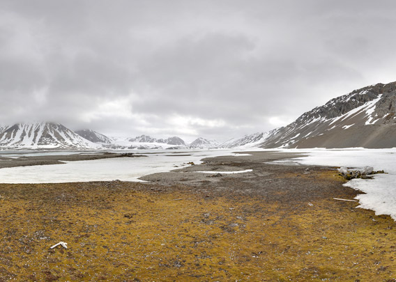
When you enter Hornsund, then you will soon have Gåshamna on your stardboard side, as it is on the southern side of the fjord. If “Goose bay”, as it translates, refers to geese that may have been present when the place got its name, a ship, the Dutch town Goes or an Austrian count Goess from the 19th century – the first time the name appeared was on an Austrian map, drawn by Sterneck and published in 1874 – is not known anymore. But what is well known is that Gåshamna provides reasonably good anchorage just under the coast and often enough protection from the strong east-westerly winds that are so frequent in Hornsund to allow landings in conditions that make other places just impossible.
Already the whalers knew that and established their stations in the early 17th century on both sides of the bay. They hunted „Right whales“, which we know as Bowhead whales today, and left their impressive bones in large numbers bleaching for centuries under midnight sun and polar night. Exactly as you can see them today if you get there.
These panoramas shows the western side of the bay Gåshamna.
- pano anchor link: #Gaashamna_09Juni13_33
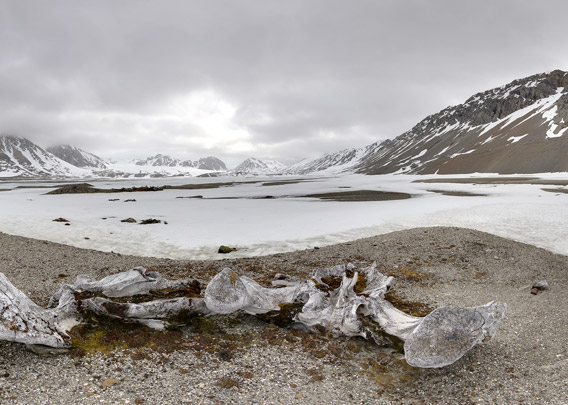
A Norwegian trapper built a hut in the early 20th century on the site of one of the 17th century blubber ovens. Today, this disturbance of a cultural heritage site would be completely illegal and impossible. Back then, it was just a convenient site, thus providing us with a pretty unique combination of remains from different periods of Spitsbergen’s history.
- pano anchor link: #Gaashamna_09Juni13_52
BOOKS, CALENDAR, POSTCARDS AND MORE
This and other publishing products of the Spitsbergen publishing house in the Spitsbergen-Shop.
-

Norwegens arktischer Norden (1): Spitzbergen
Photobook: Norway's arctic islands. The text in this book is German. [shop url="https://shop.spitzbergen.de/en/polar-books/70-norwegens-arktischer-norden-1-aerial-arctic-9783937903262.html"] ← BackOrder now -
Norwegens arktischer Norden (2): Aerial Arctic
Lofoten, Jan Mayen and Spitsbergen from the air - Photobook: Norway's arctic islands. The text in this book is German, but there is very little text, so I am sure that you will enjoy it regardless which languages you read (or not).Order now -
Poster “Svalbardhytter”
The poster "Svalbardhytter" (70 x 100 cm) visualizes the diversity of Spitsbergen's huts in a range of arctic landscapes.Order now -
Book “Svalbardhytter”
The companion book for the Svalbardhytter poster. The poster visualises the diversity of Spitsbergen‘s huts and their stories in a range of Arctic landscapes. The book tells the stories of the huts in three languages.Order now -
Spitsbergen – Svalbard. The complete guidebook
Comprehensive guidebook about Spitsbergen. Background (wildlife, plants, geology, history etc.), practical information including travelling seasons, how to travel, description of settlements, routes and regions.Order now -
Rocks and Ice. Landscapes of the North
A geographical traveling accompaniment to Spitsbergen and East Greenland (68-74°N). This is the English edition of the German book "Steine und Eis".Order now -
East Greenland in Winter
Join an exciting journey with dog, skis and tent through the wintery wastes of East Greenland! We were five guys and a dog when we started in Ittoqqortoormiit, the northernmost one of two settlements on Greenland’s east coast.Order now -
Postcard set Spitsbergen (Svalbard)
12 Spitsbergen postcards in a beautifully designed tray. Individually numbered limited edition!Order now -
Limited edition postcard set Antarctica
12 postcards which come in a beautifully designed tray. Beautiful images from South Georgia across Antarctica from the Antarctic Peninsula to the Ross Sea and up to Macquarie Island and Campbell Island.Order now
last modification: 2019-02-23 ·
copyright: Rolf Stange


-
Books, Calendar, Postcards and more

-


