


-
current
recommendations- Liefdefjord
New page dedicated to one of Spitsbergen's most beautiful fjords. Background information and many photos.

- New Spitsbergen guidebook
The new edition of my Spitsbergen guidebook is out and available now!

- Liefdefjord
New page dedicated to one of Spitsbergen's most beautiful fjords. Background information and many photos.
-
weather information

| Guidebook: Spitsbergen-Svalbard |
Home
→ Spitsbergen information
→ Islands: Spitsbergen & Co.
→ Spitsbergen (Northern part)
→ Liefdefjord
Liefdefjord
Nature and history of a famous fjord in north Spitsbergen
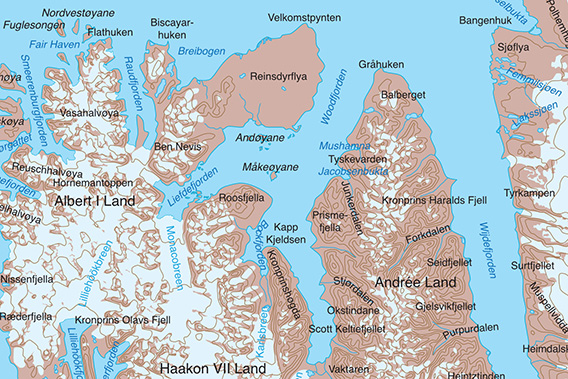
Liefdefjord is a branch of Woodfjord in north Spitsbergen.
General
Liefdefjord is in northwest Spitsbergen. It is part of the Woodfjord area: located on the west side of Woodfjord. This main fjord of the system is much larger than Liefdefjord, with 60 km (Woodfjord) versus 30 (Liefdefjord). For the geography nerds: the boundary between the two is the line from Worsleyneset at the southeast point of Reinsdyrflya to Roosneset (for further geographical detail, refer to the topographic map of the Norwegian Polar Institute.
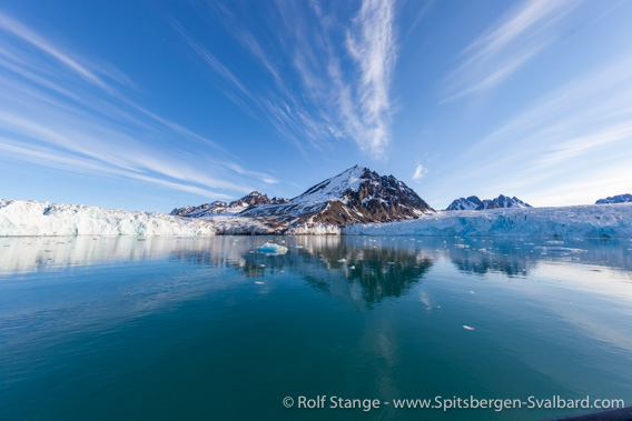
The landscape around Liefdefjord is very varied, from the wide-open plain of Reinsdyrflya in the northeast to the jagged, alpine peaks and the large glaciers of the inner part. Monacobreen is the largest and the most famous one of these glaciers. It is mainly this glacier and mountain scenery that has made Liefdefjord famous.

Spectacular centrepiece of the scenery in Liefdefjord:
Monacobreen and, further back, Seligerbreen (bird’s eye view, 2023).
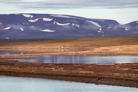
In 2019, several bird sanctuaries were established in Liefdefjord. These comprise the island groups Andøyane (including Ringholmen), Lernerøyane, Måkeøyane and Stasjonøyane. A minimum distance of 300 metres from the shore is required by law during the breeding season (15 May – 15 August).
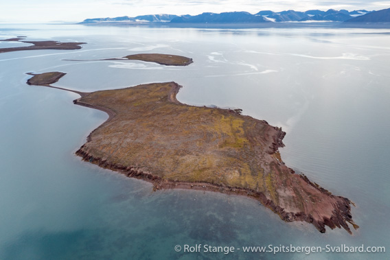
Stasjonsøyane: part of the Liefdefjord bird sanctuary.
Liefdefjord Panorama
There are several pages within this website dedicated to individual sites in Liefdefjord. These pages have photo galleries, background information and 360 degree panoramic images:
- Villa Oxford, a trapper hut and its surroundings on Reinsdyrflya
- Andøyane, a group of small islands in northern Liefdefjord
- Texas Bar, a trapper hut on the west side of Liefdefjords.
- Næssøpynten, Old Red sandstone with small waterfalls at Roosfjella.
Geology and landscape
The Liefdefjord area consists of a varied geological mosaic which makes a great contribution to the stunning and varied scenery. It is actually not that difficult to get a basic idea of the geology, hence it is worth spending some thoughts on it. This requires essentially some interest in the matter, but you don’t have to be an expert. Hence, this section is a bit longer.
To start with, there is the geological basement: schist (slate) and marble. These are rocks that were recrystallised during a phase of high temperature and pressure during the Caledonian orogeny (mountain building phase) some 450 million years ago: originally, schist had been mudstone and marble had been limestone, and pressure and heat turned them into schist and marble, respectively.
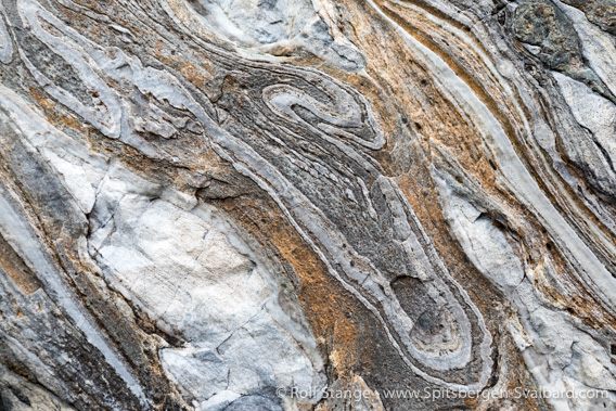
This folded marble in Hornbækpollen is part of the geological basement.
Secondly, there is a younger sedimentary cover , but it is fair to say that „younger“ is a relative term, these rocks are literally as old as the hills 🙂 when the Caledonian mountains were formed, they were immediately attacked by erosion. The eroded material that originated from the Caledonian mountains was deposited in subsiding lowlands neighbouring the elevated mountains. Due to the huge amount of sediment and the subsidence (caused by tectonic movements), sediment piles with a thickness of up to 10 kilometres or even more could develop over millions of years. The oldest part of this sediment pile consists of coarse conglomerates, while the younger layers are fine-grained sandstone and siltstone. Some of these layers show a beautiful red colour due to iron oxide. For these reasons, these sediments are collectively known as the Old Red. They were deposited during the Devonian, between 360 and a good 400 million years ago.

Devonian red sandstone: “Old Red”, here on Andøyane.
Polar bear for scale 🙂
Both structural parts, basement and Old Red, can be seen in Liefdefjord and neighbouring areas (Raudfjord, Woodfjord, Wijdefjord). Together, they form a mosaic of roughly north-south trending stripes which are separated from each other by tectonic faults (cracks).
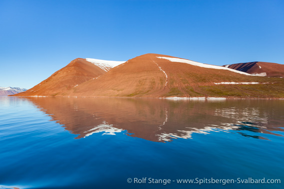
Old Red in full splendor at Roosfjella.
The difference between the older basement rocks and the (relatively) younger Old Red is easily visible because of their different colours, structures and behaviour when weathering at the surface: basement rocks tend to be responsible for steeper slopes and pointed mountains such as the ones west of Monacobreen including Stortingspresidenten (1001 metres). Old Red landscapes usually have mountains with less steep, even rounder slopes such as Roosfjella east of Lernerøyane which is a striking appearance due to its colour. And the flat islands and lowlands north of Liefdefjord – Måkeøyane, Andøyane and Stasjonsøyane as well as Reinsdyrflya – are all Old Red landscapes with distinct reddish colours and a noticeable lack of elevations.
Lernerøyane, finally, are an interesting mixture of both basement and Old Red (but basement rocks are dominant here).
This isn’t to say, of course, that Old Red landscapes are never steep and basement landscapes are never low-lying. Generally speaking, anything is possible in a given individual case, depending on a huge variety of factors including tectonic history. But in the case of Liefdefjord, it is a good starting point to understand the structure of the landscape.

Geological mosaic: light-grey marble and dark shist on Lernerøyane.
Landscape
The geology section above is a good starting point to understand the landscape in Liefdefjord. As mentioned there, the outer (northern) part of the fjord has rather low-lying, wide-open landscapes consisting of Old Red sandstone with its often beautiful colours. Remains of sub-fossil elevated beach ridges are almost omnipresent in this area, although not as distinct and easily seen as in other parts of Spitsbergen which are geologically better suited to make this phenomenon more easily visible. There are huge erratic boulders in many places.
Coastal landscape on the south side of Reinsdyrflya.
Inner Liefdefjord is characterised by high, rugged with steep slopes and sharp peaks consisting of crystalline basement rocks.
Mountains west of Monacobreen.
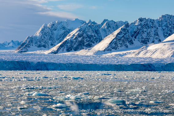
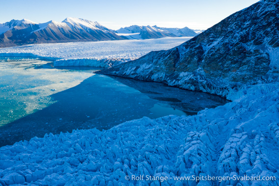
The most prominent eyecatchers are obviously the large glaciers in inner Liefdefjord, mainly Monacobreen with its 4 kilometre wide glacier front and its neighbour to the west, Seligerbreen.
Monacobreen (to the left), the mountain Stortingspresidenten (centre)
and Seligerbreen (to the right), 2016.
Monacobreen and Seligerbreen shared a glacier front north of the mountain Stortingspresidenten but the connection was lost in 2016 due to the retreat of these glaciers, when the rock slope of Stortingspresidenten became exposed on the shore.
Seligerbreen (foreground), Stortingspresidenten (centre) and Monacobreen (background), 2018.
Flora and fauna
There are extensive tundra areas in the lowlands in outer Liefdefjord. They have a wide range of interesting flower species including mountain avens and moss campion, purple saxifrage and spider plant and many others. The colour display of the flowers in high summer is beautiful.

Purple saxifrage on Andøyane.
As the name Reinsdyrflya („reindeer plain“) suggests, reindeer are not uncommon in this vast lowland area, but the density is actually lower than what one might expect. Arctic foxes are common and so are polar bears, although it is my personal impression that polar bear sightings were more frequent in Liefdefjord in the years from 2000 to 2010 than they have been since. Back then, it was almost a safe bet to check the south side of Reinsdyrflya including the nearby islands for bears. And of course chances are still that the king of the Arctic is around somewhere in that area or elsewhere in Liefdefjord, but maybe not as frequently as back then. But as said, this is just my personal impression.
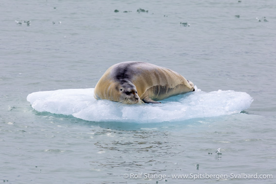
Bearded seal near Monacobreen.
The small island groups (bird sanctuaries, see above) have breeding populations of various ground breeders including common eider ducks, king eider ducks and long-tailed ducks as well as grey phalaropes, to mention just a few. Lernerøyane do not have significant breeding populations of these or other birds; it is a bit hard to understand why they were declared a bird sanctuary together with the other islands in 2019.
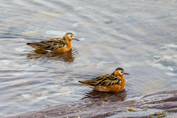
Grey phalaropes at Stasjonsøyane.
Inner Liefdefjord tends to be steep and rocky and vegetation is accordingly more sparse and restricted to suitable locations. There is a smaller bird cliff with kittiwakes high up on steep slopes between Texas Bar and Hornbækpollen.

Kittiwakes looking for food in turbulent meltwater near Monacobreen.
History
The earliest chapters of Spitsbergen’s history, whalers and Pomors, are not represented in Liefdefjord. If they were there at all, then they did not leave any visible traces.
Regarding early expeditions which contributed to mapping and general knowledge about the area, we have to mention Duke Albert I. of Monaco (expeditions in 1906 and, 1907; that’s obviously where the name “Monacobreen“ comes from). Also in 1907, the German journalist and Spitsbergen enthusiast Theodor Lerner was in Liefdefjord with his little expedition. They did some mapping in then area (placenames: Stasjonsøyane – they had a geodetic station there, but that was actually nothing more than a topographic landmark – and Lernerøyane).
Trappers had their hunting grounds in Liefdefjord. Neighbouring Woodfjord was usually the core of their territory and the place where they had their wintering stations (mainly Mushamna and Gråhuken). They had a couple of smaller huts in Liefdefjord which they used to extend their hunting area. Two of these huts are still existing, Texas Bar (built in 1927) and Villa Oxford (1924). Both were built by a then young Hilmar Nøis, who became one of the veterans of the trade in Spitsbergen and thus achieved local fame. He was far from being the only one in his family who spent their lives hunting and wintering in the Arctic. His uncle Martin Pettersen Nøis was involved when Texas Bar was built.
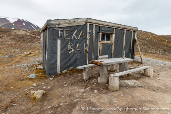
Texas Bar, a trapper hut in Liefdefjord and today a popular tourist site, as is made obvious by erosion.
There were more trapper huts in Liefdefjord, but some were destroyed during the second world war by the Germans who had a war weather station known as Kreuzritter in Sørdalen on Reinsdyrflya (northwest of Andøyane) in 1943-44. There are still some scattered remains of the station and the grave of station leader Knöspel, who died when a mine exploded that he tried to defuse just before they were to be picked up.
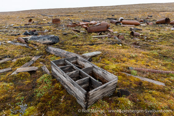
Remains of the war weather station Kreuzritter.
In 1990-92, Liefdefjord was the main working area of a large scientific expedition led by geography professor Blümel from Stuttgart in Germany, the SPE (German Geoscientific Spitsbergen Expedition). They did mainly work on geomorphology, that is processes contributing to landscape development (sediment transport in rivers, solifluction), glaciers, geology and biology/ecology. Andreas Fieber, a young expedition member, died during an accident when a slush avalanche rushed down from a snow-covered area and a glacier.
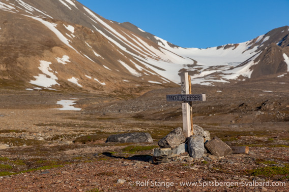
Memorial cross for Andreas Fieber who died in 1992 in an avalanche on the area behind the cross to the left.
Photo gallery – Liefdefjord
Pictures from the years 2009 to 2023. The gallery is a collection of impressions from Liefdefjord, from the wide-open tundra and lowlands of Reinsdyrflya and nearby islands (Stasjonsøyane, Andøyane) to the alpine mountain and glacier scenery at Monacobreen and the ice that often covers the fjord there. Wildlife, flowers, various times of year from the early to the late summer with all sorts of weather, light and snow conditions are represented to give an idea of the variety of the landscape and nature (and some history) of the area.
- gallery anchor link: #gallery_2946
Click on thumbnail to open an enlarged version of the specific photo.


BOOKS, CALENDAR, POSTCARDS AND MORE
This and other publishing products of the Spitsbergen publishing house in the Spitsbergen-Shop.
-

Norwegens arktischer Norden (1): Spitzbergen
Photobook: Norway's arctic islands. The text in this book is German. [shop url="https://shop.spitzbergen.de/en/polar-books/70-norwegens-arktischer-norden-1-aerial-arctic-9783937903262.html"] ← BackOrder now -
Norwegens arktischer Norden (2): Aerial Arctic
Lofoten, Jan Mayen and Spitsbergen from the air - Photobook: Norway's arctic islands. The text in this book is German, but there is very little text, so I am sure that you will enjoy it regardless which languages you read (or not).Order now -
Poster “Svalbardhytter”
The poster "Svalbardhytter" (70 x 100 cm) visualizes the diversity of Spitsbergen's huts in a range of arctic landscapes.Order now -
Book “Svalbardhytter”
The companion book for the Svalbardhytter poster. The poster visualises the diversity of Spitsbergen‘s huts and their stories in a range of Arctic landscapes. The book tells the stories of the huts in three languages.Order now -
Spitsbergen – Svalbard. The complete guidebook
Comprehensive guidebook about Spitsbergen. Background (wildlife, plants, geology, history etc.), practical information including travelling seasons, how to travel, description of settlements, routes and regions.Order now -
Rocks and Ice. Landscapes of the North
A geographical traveling accompaniment to Spitsbergen and East Greenland (68-74°N). This is the English edition of the German book "Steine und Eis".Order now -
East Greenland in Winter
Join an exciting journey with dog, skis and tent through the wintery wastes of East Greenland! We were five guys and a dog when we started in Ittoqqortoormiit, the northernmost one of two settlements on Greenland’s east coast.Order now -
Postcard set Spitsbergen (Svalbard)
12 Spitsbergen postcards in a beautifully designed tray. Individually numbered limited edition!Order now -
Limited edition postcard set Antarctica
12 postcards which come in a beautifully designed tray. Beautiful images from South Georgia across Antarctica from the Antarctic Peninsula to the Ross Sea and up to Macquarie Island and Campbell Island.Order now
last modification: 2023-10-26 ·
copyright: Rolf Stange
-
Books, Calendar, Postcards and more

-


