-
current
recommendations- Liefdefjord
New page dedicated to one of Spitsbergen's most beautiful fjords. Background information and many photos.
- New Spitsbergen guidebook
The new edition of my Spitsbergen guidebook is out and available now!
- Liefdefjord
New page dedicated to one of Spitsbergen's most beautiful fjords. Background information and many photos.
Page Structure
-
Spitsbergen-News
- Select Month
- June 2025
- May 2025
- April 2025
- March 2025
- February 2025
- January 2025
- December 2024
- November 2024
- October 2024
- September 2024
- August 2024
- July 2024
- June 2024
- May 2024
- April 2024
- March 2024
- February 2024
- January 2024
- December 2023
- November 2023
- October 2023
- September 2023
- August 2023
- July 2023
- June 2023
- May 2023
- April 2023
- March 2023
- February 2023
- January 2023
- December 2022
- November 2022
- October 2022
- September 2022
- August 2022
- July 2022
- June 2022
- May 2022
- April 2022
- March 2022
- February 2022
- January 2022
- December 2021
- November 2021
- October 2021
- September 2021
- August 2021
- July 2021
- June 2021
- May 2021
- April 2021
- March 2021
- February 2021
- January 2021
- December 2020
- November 2020
- October 2020
- September 2020
- August 2020
- July 2020
- June 2020
- May 2020
- April 2020
- March 2020
- February 2020
- January 2020
- December 2019
- November 2019
- October 2019
- September 2019
- August 2019
- July 2019
- June 2019
- May 2019
- April 2019
- March 2019
- February 2019
- January 2019
- December 2018
- November 2018
- October 2018
- September 2018
- August 2018
- July 2018
- June 2018
- May 2018
- April 2018
- March 2018
- February 2018
- January 2018
- December 2017
- November 2017
- October 2017
- September 2017
- August 2017
- July 2017
- June 2017
- May 2017
- April 2017
- March 2017
- February 2017
- January 2017
- December 2016
- November 2016
- October 2016
- September 2016
- August 2016
- July 2016
- June 2016
- May 2016
- April 2016
- March 2016
- February 2016
- January 2016
- December 2015
- November 2015
- October 2015
- September 2015
- August 2015
- July 2015
- June 2015
- May 2015
- April 2015
- March 2015
- February 2015
- January 2015
- December 2014
- November 2014
- October 2014
- September 2014
- August 2014
- July 2014
- June 2014
- May 2014
- April 2014
- March 2014
- February 2014
- January 2014
- December 2013
- November 2013
- October 2013
- September 2013
- August 2013
- July 2013
- June 2013
- May 2013
- April 2013
- March 2013
- February 2013
- January 2013
- December 2012
- November 2012
- October 2012
- September 2012
- August 2012
- July 2012
- June 2012
- May 2012
- April 2012
- March 2012
- February 2012
- January 2012
- December 2011
- November 2011
- October 2011
- September 2011
- August 2011
- May 2011
- April 2011
- March 2011
- February 2011
- January 2011
- December 2010
- November 2010
- September 2010
- August 2010
- July 2010
- June 2010
- May 2010
- April 2010
- March 2010
- February 2010
- November 2009
- October 2009
- August 2009
- July 2009
- June 2009
- May 2009
- April 2009
- March 2009
- February 2009
- January 2009
- December 2008
- November 2008
- October 2008
- August 2008
- July 2008
- June 2008
- May 2008
- April 2008
- March 2008
- February 2008
- April 2000
- Select Month
-
weather information
-
Newsletter

| Guidebook: Spitsbergen-Svalbard |
Home
→ * Photos, Panoramas, Videos and Webcams
→ Spitsbergen Panoramas
→ Kvalvågen, Boltodden
Kvalvågen, Boltodden
Dinosaur footprints on the east coast of Spitsbergen
- pano anchor link: #Boltodden_13Aug13_044
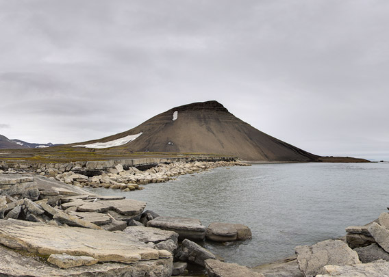
The bay Kvalvågen is on the east coast of Spitsbergen. It is easy to reach in winter by snow mobile (but this is only permitted for locals or with special permission). In summer, the east coast is, well, not further away, but much more remote, as it is more difficult to get there and the area is much more rarely visited then. The rocky shoreline does not exactly offer many well-sheltered landing sites, and landings are only possible in calm weather and sea conditions.

Landing site at Boltodden (Kvalvågen) on a not very hospitable rocky coast.
- pano anchor link: #Boltodden_13Aug13_008
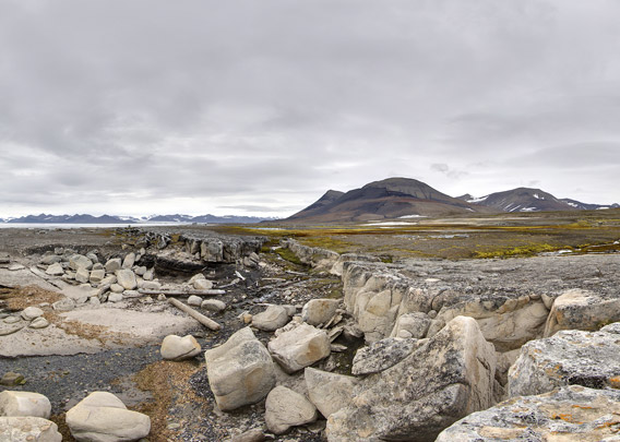
The rocky shoreline is geologically interesting: the rocks are sandstone, delta deposits of rivers that were flowing there almost 130 million years ago (lower Cretaceous), building up their river mouth sediments over large areas, similar to the Mississippi river delta today. This sandstone can be found in many places in Spitsbergen, it is well known from several sites in Isfjord including Bohemanneset (where you can see the coal seams quite nicely) and Festningen west of Grønfjord, where this sandstone, the “Festningen sandstone”, also got its name.

Coastal cliffs outside at Kvalhovden (viewing east) with layers from the lower Cretaceous: Helvetiafjellet-formation including the Festningen sandstone at the bottom, overlain by the Carolinefjellet-formation with its darker, more fine-grained sediments. Noteworthy are also the growth faults at the bottom: large blocks of sandstone that moved within the surrounding mud which was not yet solidified, shortly after deposition. In other words, faulting induced by gravitation and not by tectonics.
To be precise: the Festningen sandstone belongs to the Helvetiafjellet formation (named after a mountain in Adventdalen), which again is part of the Adventdalen group, to work our way through the local stratigraphic hierarchy. Internationally speaking, the time of deposition of the Festningen sandstone happened during the Barremian (130.7-126.3 million years ago), which is part of the lower Cretaceous. Just in case you wanted to know.

Detailed view of the Festningen sandstone with cross bedding. Coast of Boltodden, Kvalvågen.
- pano anchor link: #Boltodden_13Aug13_026
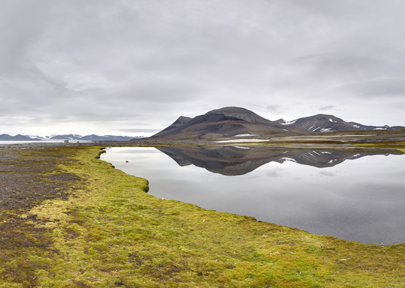
Lagoon with mossy shore on the flat land near the coast at Boltodden.

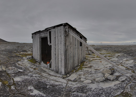
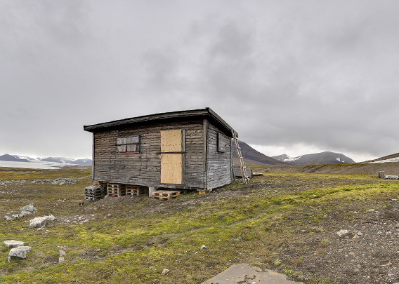
Hut at Boltodden, Kvalvågen, view to the west.
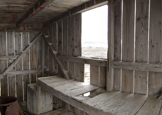
This is the older one of two huts near the shore at Boltodden. It was probably built in 1923 by the British “Northern Exploration Company” (NEC) to claim the area in case coal or other minerals would be found later.

The older (1923, NEC) hut at Boltodden, Kvalvågen. Again viewing west, but now with the lagoon in the foreground and the glaciers (Strongbreen) in the background.
- pano anchor link: #Boltodden_13Aug13_062
- pano anchor link: #Boltodden_13Aug13_080
Inside the 1923 NEC hut.
- pano anchor link: #Boltodden_13Aug13_375
This more recent hut is a bit higher up from the coast. It was damaged in spring 2014, probably by a snow avalanche. Hope it will be repaired.

Ruin of yet another hut at Boltodden, Kvalvågen. Maybe the one built in 1909 for a wintering by the hunters Einar Johan Pedersen and Arne Jensen Sommerø. The latter had to cut off some of his toes damaged by frostbite during the winter, he left them in the hut when they left in August 1910. They rowed with a small boat all the way around Sørkapp to Isfjord and Longyearbyen (then still Longyear City) as no ship came to pick them up.
After a little walk into the valley Kvalhovddalen and ascending about 250 metres to the southern end of the mountain ridge Kvalhovden, you have this magnificent view all around you. The wide Storfjord to the east with Edgeøya on the horizon. The east coast of Spitsbergen stretching into the far distance to the north and south. The glacier Strongbreen, its feature that mostly deserves being described as “strong” being the strong retreat of recent years, in the west. The best part of it all may be the rocky coastline that you have nearby, Boltodden and Sporodden.
- pano anchor link: #Boltodden_09Aug14_253
- pano anchor link: #Boltodden_13Aug13_238
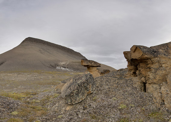
These two last panoramas are from Sporodden, some hundred metres east of Boltodden. The name (“track point”) is derived from the dinosaur tracks, although they were actually found at Boltodden. These dinosaurs, carnivorous ones as opposed to the vegetarian Iguanodons who left their tracks at the same time at Festningen (Isfjord), walked around here (which was further south) when the Festningen sandstone was still a soft river delta of white sand, surrounded by swamplands with forests. Today, Sporodden provides an interesting, beautiful scenery, with some mushroom-shaped sandstone rocks quite reminiscent of Colorado, if it was just a few degrees warmer.
- pano anchor link: #Boltodden_13Aug13_256
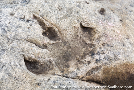
Dinosaur footprints at Boltodden, Kvalvågen. About 30 cm large footprints of the cretaceous Iguanodon, a vegetarian dinosaur species.

Moss campion.
BOOKS, CALENDAR, POSTCARDS AND MORE
This and other publishing products of the Spitsbergen publishing house in the Spitsbergen-Shop.
last modification: 2019-04-29 ·
copyright: Rolf Stange
