


-
current
recommendations- Liefdefjord
New page dedicated to one of Spitsbergen's most beautiful fjords. Background information and many photos.

- New Spitsbergen guidebook
The new edition of my Spitsbergen guidebook is out and available now!
- Liefdefjord
New page dedicated to one of Spitsbergen's most beautiful fjords. Background information and many photos.
-
weather information

| Guidebook: Spitsbergen-Svalbard |
Edgeøya: Åneset
360 degree panoramas and some history
Åneset is a flat point near the northeastern corner of Edgeøya, in the eastern part of Freemansund. The high-arctic character really comes through in this barren landscape! One main factor is the cold east Spitsbergen current which keeps the climate in this area colder than on the west coast, where a northern branch of the Gulf Stream keeps the climate milder and more maritime and the waters largely ice-free year round.
- pano anchor link: #180722a_Aaneset_045HDR

The scenery here is characterised by a wide-stretching and largely flat coastal plain. On a smaller scale, raised beaches and ice wedges make for some lovely geometric patterns in the barren tundra over large areas. How good would it be to see that from the air! Well, not impossible these days 🙂
- pano anchor link: #180722a_Aaneset_026HDR
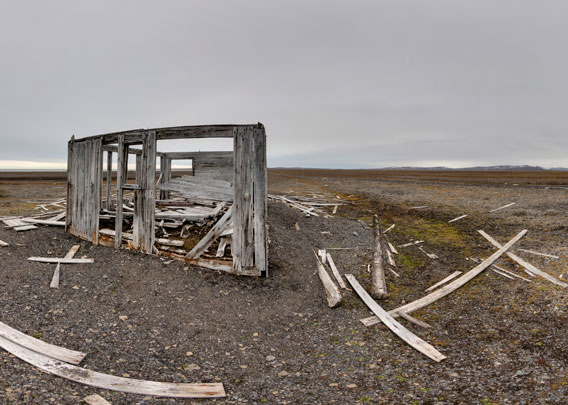
There are remains of a hut standing as a ruin in this forgotten corner of the Arctic. It is not much but a ruin, but it is the oldest hut built by “modern” (post Pomor) trappers on Edgeøya. It was a group of hunters who came with the small sealing ship Elina Kristine and built the hut in 1904. One part of the group kind of stranded on Tusenøyane, on the south side of Edgeøya, for a good part of the winter.
- pano anchor link: #180722a_Aaneset_064HDR
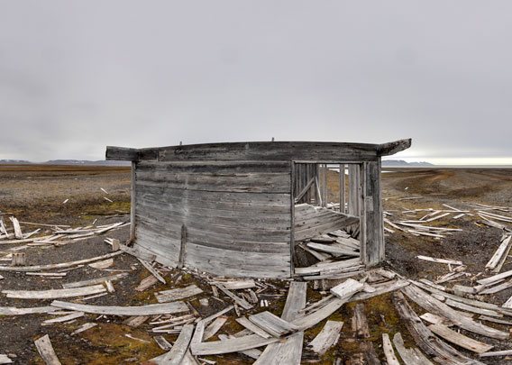
Another view of the hut at Åneset. I shot these panoramas in July 2018; the hut is about to fall apart quickly now and soon there won’t be anything left but scattered remains.
BOOKS, CALENDAR, POSTCARDS AND MORE
This and other publishing products of the Spitsbergen publishing house in the Spitsbergen-Shop.
-

Norwegens arktischer Norden (1): Spitzbergen
Photobook: Norway's arctic islands. The text in this book is German. [shop url="https://shop.spitzbergen.de/en/polar-books/70-norwegens-arktischer-norden-1-aerial-arctic-9783937903262.html"] ← BackOrder now -
Norwegens arktischer Norden (2): Aerial Arctic
Lofoten, Jan Mayen and Spitsbergen from the air - Photobook: Norway's arctic islands. The text in this book is German, but there is very little text, so I am sure that you will enjoy it regardless which languages you read (or not).Order now -
Poster “Svalbardhytter”
The poster "Svalbardhytter" (70 x 100 cm) visualizes the diversity of Spitsbergen's huts in a range of arctic landscapes.Order now -
Book “Svalbardhytter”
The companion book for the Svalbardhytter poster. The poster visualises the diversity of Spitsbergen‘s huts and their stories in a range of Arctic landscapes. The book tells the stories of the huts in three languages.Order now -
Spitsbergen – Svalbard. The complete guidebook
Comprehensive guidebook about Spitsbergen. Background (wildlife, plants, geology, history etc.), practical information including travelling seasons, how to travel, description of settlements, routes and regions.Order now -
Rocks and Ice. Landscapes of the North
A geographical traveling accompaniment to Spitsbergen and East Greenland (68-74°N). This is the English edition of the German book "Steine und Eis".Order now -
East Greenland in Winter
Join an exciting journey with dog, skis and tent through the wintery wastes of East Greenland! We were five guys and a dog when we started in Ittoqqortoormiit, the northernmost one of two settlements on Greenland’s east coast.Order now -
Postcard set Spitsbergen (Svalbard)
12 Spitsbergen postcards in a beautifully designed tray. Individually numbered limited edition!Order now -
Limited edition postcard set Antarctica
12 postcards which come in a beautifully designed tray. Beautiful images from South Georgia across Antarctica from the Antarctic Peninsula to the Ross Sea and up to Macquarie Island and Campbell Island.Order now
last modification: 2019-12-16 ·
copyright: Rolf Stange


-
Books, Calendar, Postcards and more

-


