


-
current
recommendations- Liefdefjord
New page dedicated to one of Spitsbergen's most beautiful fjords. Background information and many photos.

- New Spitsbergen guidebook
The new edition of my Spitsbergen guidebook is out and available now!
- Liefdefjord
New page dedicated to one of Spitsbergen's most beautiful fjords. Background information and many photos.
-
weather information

| Guidebook: Spitsbergen-Svalbard |
Home
→ * Photos, Panoramas, Videos and Webcams
→ Spitsbergen Panoramas
→ Dickson Land: Yggdrasilkampen
Dickson Land: Yggdrasilkampen
Yggdrasilkampen 1
- pano anchor link: #170906a_Yggdrasilkampen_055HDR-Pano
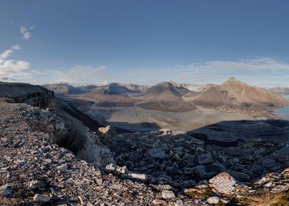
Yggdrasilkampen is the mountain on the southern side of Mimerdalen, where the well-known Russian ghost settlement of Pyramiden is situated. It is the long ridge which you constantly see as you look from Pyramiden across the valley. An impressive mountain with a wide plateau with some protruding ledges. It won’t surprise you to read that the view from these ledges is great. The fact that the sun is coming from a good direction for most views of interest during mid-day and afternoon does not hurt either. To the west, you can see the valleys disappearing in the distance in beautiful Dickson Land, you have got Pyramiden more or less to the north or northeast and all the way to the east, you can see Billefjord and Nordenskiöldbreen. All this together makes for quite an impressive panorama! I hope that the panos on this page manage to transport a bit of that impression.
Yggdrasilkampen 2
- pano anchor link: #170906a_Yggdrasilkampen_055HDR-Pano

The „problem“ is that you have to have to get there to enjoy the view. As a round trip from and to Pyramiden, ascending Yggdrasilkampen from Billefjord and descending down to the valley in the west, it is almost 20 kilometres. You are climbing a net altitude of 583 metres. The ascent and descent are both quite challenging: steep slopes with lots of loose scree, that definitely requires good confidence to move around in that kind of terrain. And you have to know the right spots where you actually can get up and down, mostly it is just too steep!
BOOKS, CALENDAR, POSTCARDS AND MORE
This and other publishing products of the Spitsbergen publishing house in the Spitsbergen-Shop.
-

Norwegens arktischer Norden (1): Spitzbergen
Photobook: Norway's arctic islands. The text in this book is German. [shop url="https://shop.spitzbergen.de/en/polar-books/70-norwegens-arktischer-norden-1-aerial-arctic-9783937903262.html"] ← BackOrder now -
Norwegens arktischer Norden (2): Aerial Arctic
Lofoten, Jan Mayen and Spitsbergen from the air - Photobook: Norway's arctic islands. The text in this book is German, but there is very little text, so I am sure that you will enjoy it regardless which languages you read (or not).Order now -
Poster “Svalbardhytter”
The poster "Svalbardhytter" (70 x 100 cm) visualizes the diversity of Spitsbergen's huts in a range of arctic landscapes.Order now -
Book “Svalbardhytter”
The companion book for the Svalbardhytter poster. The poster visualises the diversity of Spitsbergen‘s huts and their stories in a range of Arctic landscapes. The book tells the stories of the huts in three languages.Order now -
Spitsbergen – Svalbard. The complete guidebook
Comprehensive guidebook about Spitsbergen. Background (wildlife, plants, geology, history etc.), practical information including travelling seasons, how to travel, description of settlements, routes and regions.Order now -
Rocks and Ice. Landscapes of the North
A geographical traveling accompaniment to Spitsbergen and East Greenland (68-74°N). This is the English edition of the German book "Steine und Eis".Order now -
East Greenland in Winter
Join an exciting journey with dog, skis and tent through the wintery wastes of East Greenland! We were five guys and a dog when we started in Ittoqqortoormiit, the northernmost one of two settlements on Greenland’s east coast.Order now -
Postcard set Spitsbergen (Svalbard)
12 Spitsbergen postcards in a beautifully designed tray. Individually numbered limited edition!Order now -
Limited edition postcard set Antarctica
12 postcards which come in a beautifully designed tray. Beautiful images from South Georgia across Antarctica from the Antarctic Peninsula to the Ross Sea and up to Macquarie Island and Campbell Island.Order now
last modification: 2017-12-27 ·
copyright: Rolf Stange


-
Books, Calendar, Postcards and more

-


