


-
current
recommendations- Liefdefjord
New page dedicated to one of Spitsbergen's most beautiful fjords. Background information and many photos.

- New Spitsbergen guidebook
The new edition of my Spitsbergen guidebook is out and available now!
- Liefdefjord
New page dedicated to one of Spitsbergen's most beautiful fjords. Background information and many photos.
-
weather information

| Guidebook: Spitsbergen-Svalbard |
Home → * Photos, Panoramas, Videos and Webcams → Spitsbergen Panoramas → Nordenskiöldbreen
Nordenskiöldbreen
Nordenskiöldbreen
The glacier Nordenskiöldbreen is one of the largest glaciers in Isfjord, in reach from Longyearbyen. It is frequently visited as part of boat trips to Pyramiden during the summer or during snowmobile excursions from Longyearbyen to Pyramiden in spring (if the ice in Billefjord is solid enough to travel across the frozen fjord to Pyramiden). The glacier has repeated strongly in recent years, but it is still very impressive.
- pano anchor link: #Nordenskioldbreen_01Mai13_08
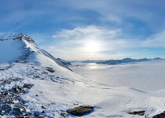
Urmstonfjellet is towering high above its icy surroundings south of upper Nordenskiöldbreen. This is the amazing view from its northeastern corner. In the west, you can see Billefjord and, if you look carefully, the Russian settlement Pyramiden. The huge glacier Nordenskiöldbreen is dominating much of the scenery. In the east, it leads up to the ice cap Lomonossovfonna.
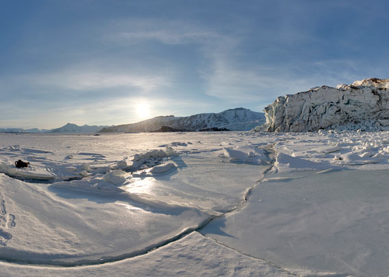
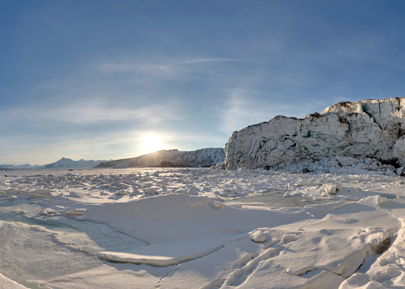
The impressive calving cliff of Nordenskiöldbreen in early May.
- pano anchor link: #Nordenskioldbreen_01Mai13_011
- pano anchor link: #Nordenskioldbreen_01Mai13_046

- pano anchor link: #Nordenskioldbreen_01Mai13_091
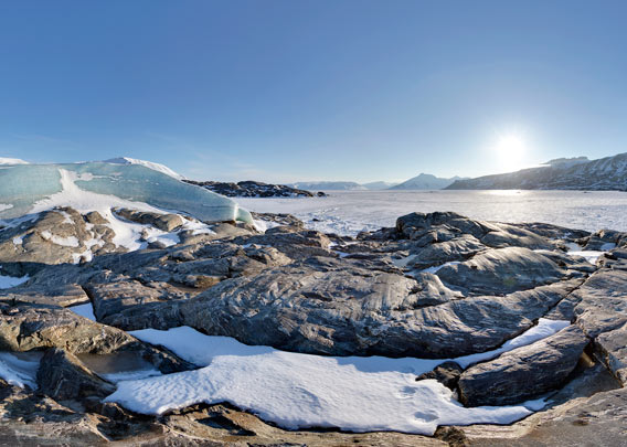
As so many of its kind, Nordenskiöldbreen has retreated in recent years and thus some small, rocky islets came out under the ice – again, as they had been ice-free before and were covered by the glacier during an advance. The rocks are amongst the oldest known in Spitsbergen
- pano anchor link: #Nordenskioldbreen_02Mai13_14
Gallery Nordenskiöldbreen
Finally a couple of impressions of Nordenskiöldbreen from different perspectives.
- gallery anchor link: #gallery_1881
Click on thumbnail to open an enlarged version of the specific photo.


BOOKS, CALENDAR, POSTCARDS AND MORE
This and other publishing products of the Spitsbergen publishing house in the Spitsbergen-Shop.
-

Norwegens arktischer Norden (1): Spitzbergen
Photobook: Norway's arctic islands. The text in this book is German. [shop url="https://shop.spitzbergen.de/en/polar-books/70-norwegens-arktischer-norden-1-aerial-arctic-9783937903262.html"] ← BackOrder now -
Norwegens arktischer Norden (2): Aerial Arctic
Lofoten, Jan Mayen and Spitsbergen from the air - Photobook: Norway's arctic islands. The text in this book is German, but there is very little text, so I am sure that you will enjoy it regardless which languages you read (or not).Order now -
Poster “Svalbardhytter”
The poster "Svalbardhytter" (70 x 100 cm) visualizes the diversity of Spitsbergen's huts in a range of arctic landscapes.Order now -
Book “Svalbardhytter”
The companion book for the Svalbardhytter poster. The poster visualises the diversity of Spitsbergen‘s huts and their stories in a range of Arctic landscapes. The book tells the stories of the huts in three languages.Order now -
Spitsbergen – Svalbard. The complete guidebook
Comprehensive guidebook about Spitsbergen. Background (wildlife, plants, geology, history etc.), practical information including travelling seasons, how to travel, description of settlements, routes and regions.Order now -
Rocks and Ice. Landscapes of the North
A geographical traveling accompaniment to Spitsbergen and East Greenland (68-74°N). This is the English edition of the German book "Steine und Eis".Order now -
East Greenland in Winter
Join an exciting journey with dog, skis and tent through the wintery wastes of East Greenland! We were five guys and a dog when we started in Ittoqqortoormiit, the northernmost one of two settlements on Greenland’s east coast.Order now -
Postcard set Spitsbergen (Svalbard)
12 Spitsbergen postcards in a beautifully designed tray. Individually numbered limited edition!Order now -
Limited edition postcard set Antarctica
12 postcards which come in a beautifully designed tray. Beautiful images from South Georgia across Antarctica from the Antarctic Peninsula to the Ross Sea and up to Macquarie Island and Campbell Island.Order now
last modification: 2020-10-13 ·
copyright: Rolf Stange


-
Books, Calendar, Postcards and more

-


