


-
current
recommendations- Liefdefjord
New page dedicated to one of Spitsbergen's most beautiful fjords. Background information and many photos.

- New Spitsbergen guidebook
The new edition of my Spitsbergen guidebook is out and available now!
- Liefdefjord
New page dedicated to one of Spitsbergen's most beautiful fjords. Background information and many photos.
-
weather information

| Guidebook: Spitsbergen-Svalbard |
Langeøya
Panorama of an island within Bastianøyane, Hinlopen Strait

The island of Langeøya is one of Bastianøyane at the southern end of Hinlopen Strait.
At Langeøya, the name (in Norwegian/German) might well be descriptive, indicating „Long Island“: it is no more than 50-60 metres wide in several places, but about six kilometres long. But the name does not describe the shape (then, in correct Norwegian, it should be Langøya, not Langeøya), the island is rather named after a German 19th century geographer, just as with the neighbouring islands. Together, they form the small archipelago of the Bastianøyane, a group of small islands which is situated in the southern Hinlopen Strait.

View over Langeøya.
Langeøya and Kiepertøya, a bit further to the southeast, are the two largest islands of the Bastianøyane. Beyond these two, only Pescheløya is worth mentioning; the other islands are hardly more than skerries and rocks.
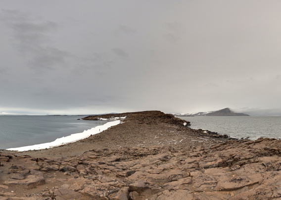
Langeøya – Pano 1
- pano anchor link: #190813f_Langeoya_001HDR
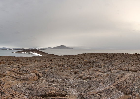
Regarding Langeøya (and Kiepertøya, which is similar), it is the shape that it really striking: it is made up of a series of five rocky hills which are between 37 and 54 metres high and connected by narrow, low-lying land bridges. Geologically speaking, Langeøya consists of dolerite, a basalt-like rock. The low-lying land bridges have some rocky beaches with some driftwood (and the inevitable marine plastic litter).

The bird’s eye perspective really brings out
Langeøya’s very characteristic landscape structure.
Langeøya – Pano 2
- pano anchor link: #190813f_Langeoya_020HDR
Vegetation is mostly restricted to lichens. There is no „stationary“ wildlife other than some breeding birds such as arctic terns and – at a little pond – red-throated divers. But it is not unusual to see one or several walrus swimming around in this neighbourhood, and there is certainly a polar bear roaming between the rocky hills somewhere on these islands. There was an accident with a polar bear with fatal outcome on neighbouring Kiepertøya – so be careful if you ever get here.
BOOKS, CALENDAR, POSTCARDS AND MORE
This and other publishing products of the Spitsbergen publishing house in the Spitsbergen-Shop.
-

Norwegens arktischer Norden (1): Spitzbergen
Photobook: Norway's arctic islands. The text in this book is German. [shop url="https://shop.spitzbergen.de/en/polar-books/70-norwegens-arktischer-norden-1-aerial-arctic-9783937903262.html"] ← BackOrder now -
Norwegens arktischer Norden (2): Aerial Arctic
Lofoten, Jan Mayen and Spitsbergen from the air - Photobook: Norway's arctic islands. The text in this book is German, but there is very little text, so I am sure that you will enjoy it regardless which languages you read (or not).Order now -
Poster “Svalbardhytter”
The poster "Svalbardhytter" (70 x 100 cm) visualizes the diversity of Spitsbergen's huts in a range of arctic landscapes.Order now -
Book “Svalbardhytter”
The companion book for the Svalbardhytter poster. The poster visualises the diversity of Spitsbergen‘s huts and their stories in a range of Arctic landscapes. The book tells the stories of the huts in three languages.Order now -
Spitsbergen – Svalbard. The complete guidebook
Comprehensive guidebook about Spitsbergen. Background (wildlife, plants, geology, history etc.), practical information including travelling seasons, how to travel, description of settlements, routes and regions.Order now -
Rocks and Ice. Landscapes of the North
A geographical traveling accompaniment to Spitsbergen and East Greenland (68-74°N). This is the English edition of the German book "Steine und Eis".Order now -
East Greenland in Winter
Join an exciting journey with dog, skis and tent through the wintery wastes of East Greenland! We were five guys and a dog when we started in Ittoqqortoormiit, the northernmost one of two settlements on Greenland’s east coast.Order now -
Postcard set Spitsbergen (Svalbard)
12 Spitsbergen postcards in a beautifully designed tray. Individually numbered limited edition!Order now -
Limited edition postcard set Antarctica
12 postcards which come in a beautifully designed tray. Beautiful images from South Georgia across Antarctica from the Antarctic Peninsula to the Ross Sea and up to Macquarie Island and Campbell Island.Order now
last modification: 2024-06-22 ·
copyright: Rolf Stange


-
Books, Calendar, Postcards and more

-


