


-
current
recommendations- Liefdefjord
New page dedicated to one of Spitsbergen's most beautiful fjords. Background information and many photos.

- New Spitsbergen guidebook
The new edition of my Spitsbergen guidebook is out and available now!
- Liefdefjord
New page dedicated to one of Spitsbergen's most beautiful fjords. Background information and many photos.
-
weather information

| Guidebook: Spitsbergen-Svalbard |
Hiorthhamn
360°-Panoramas
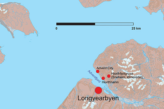
Hiorthhamn is located on the north side of Adventfjord, opposite Longyearbyen.
On the north side of Adventfjord, opposite Longyearbyen, lie the remains of the old mining settlement of Hiorthamn from the early 20th century, which today offers plenty of space for exploring and beautiful photo opportunities. Hiorthhamn is one of Spitsbergen’s largest and most comprehensive industrial monuments from the early mining era.
In 1917-18, more than 60 workers were employed at Hiorthhamn to get the operation up and running. Production was supposed to start the following year, but technical problems and the Spanish flu contributed to the fact that only a meagre 838 tonnes of coal were extracted from the mountain in Sneheim high up on Hiorthfjellet. The mine where Hiorthhamn’s coal came from was no less than 582 metres above sea level! It was officially called Hiorthfjellgruve, but unofficially it was usually called Sneheim (‘Snow Home’). Sneheim has its own page (click here).
Mining in Sneheim/Hiorthfjellgruve/Hiorthhamn from 1917 onwards was carried out under the direction of De Norske Kulfelter, which had taken over the coal deposits there after several changes of ownership; the ownership structure in the early years of mining in Spitsbergen was often confusing and chaotic, with overlapping claims. Engineer Fredrik Hiorth was the leading figure in De Norske Kulfelter, which also explains the origin of the names Hiorthhamn and Hiorthfjellet. Originally, the place was spelt Hiorthhavn, and from 1938 it was called Moskushamn for a while, as musk oxen from Greenland were released there in 1929, but later died out again. Today the place is called Hiorthhamn again.
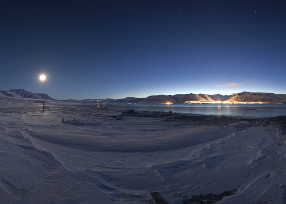
Hiorthhamn in the polar night
- pano anchor link: #Hiorthhamn_08Jan14_055
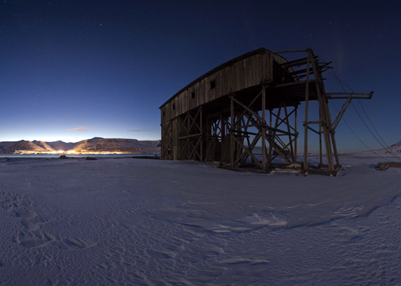
Impressions from the polar night (early January). The moon is in the sky. Longyearbyen lies brightly lit on the other side of the fjord.
- pano anchor link: #Hiorthhamn_08Jan14_079
In 1917, De Norske Kulfelter began to prepare for mining in Hiorthhamn. Initially, some buildings were brought from Advent City, a few kilometres further northwest in Advent Fjord, where an English company, the Spitsbergen Coal and Trading Company, had made an ultimately unsuccessful attempt to mine coal from 1904 to 1908.
The difficult conditions, not least due to the location of the Sneheim mine on a steep slope at an altitude of 582 metres, and the Spanish flu contributed to the fact that mining in Sneheim/Hiorthhamn was largely discontinued as early as 1921. After that, only sporadic attempts were made to revitalise the small mining village, but the hammer finally fell in 1940. Until then, hardly more than 10,000 tonnes of coal had been produced in the Hiorthfjell mine, and the workforce had probably never exceeded around 80.
A few of the many buildings, including residential buildings and warehouses, smithies and workshops etc., are still standing. Several of the associated huts in the neighbourhood are still in private use today, which of course limits photography. This is another reason why I am concentrating here on the facilities near the shore, which were not used for accommodation or similar, but for industrial purposes and can still be visited today, which is really worthwhile.
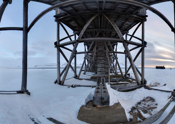
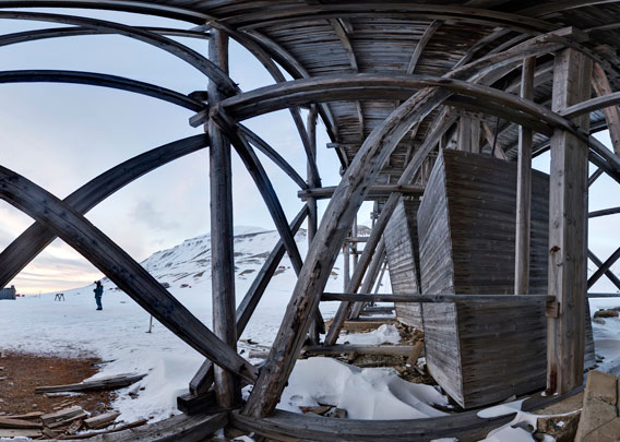
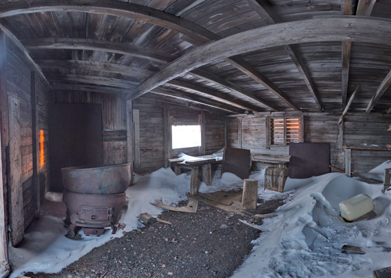
Hiorthhamn: the central cableway station (ground level)
The bottom station of the coal-fired cable car is the most striking building in Hiorthhamn and is unique in its kind in Spitsbergen. It was built during Hiorthhamn’s last phase of operation, 1938-40.
The first panorama was taken on the west side of the valley station of the coal-cable car. The building nearby, towards the shore, is the old smithy (see below). All panoramas are from 2013.
- pano anchor link: #Hiorthhamn_06April13_096

- pano anchor link: #Hiorthhamn_06April13_056
- pano anchor link: #Hiorthhamn_06April13_126
The engine room.
- pano anchor link: #Hiorthhamn_06April13_196

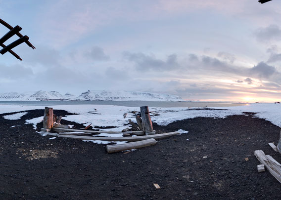
The last panorama at sea level shows the south side of the cableway station / coal loading facility, facing the shore. In the years following the photo (2013), the shore has increasingly moved inland due to coastal erosion, threatening the facility. Attempts have been made to secure it with sandbags. It remains to be seen how long this will work.
- pano anchor link: #Hiorthhamn_06April13_241
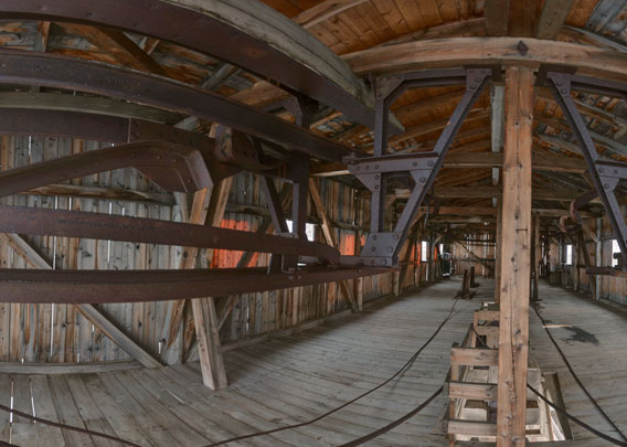
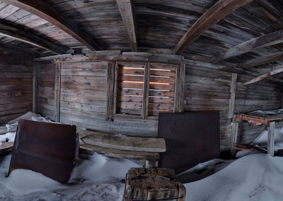
Hiorthhamn: the cableway station (upstairs)
From here we are in the upper part of the cableway station / coal loading plant:
- pano anchor link: #Hiorthhamn_06April13_396

You get here via a narrow flight of steps, more of a chicken ladder than anything else. No-one takes responsibility for the technical condition of the old system and nothing is maintained here. You have to judge for yourself whether you want to trust the ladder and the wooden floor in the upper part.
- pano anchor link: #Hiorthhamn_06April13_436
- pano anchor link: #Hiorthhamn_06April13_517

Hiorthhamn: the smithy
The smithy was located right next to the cableway station/coal loading facility. The panoramic photos are from 2013. At the beginning of March 2021, the building was moved 12 metres away from the shore to a new place as it was threatened by coastal erosion at its original location.
- pano anchor link: #Hiorthhamn_06April13_281
- pano anchor link: #Hiorthhamn_06April13_351
- pano anchor link: #Hiorthhamn_06April13_311
A few pictures of the smithy from March 2022, one year after the building was moved due to the threat of coastal erosion.
- gallery anchor link: #gallery_3423
Click on thumbnail to open an enlarged version of the specific photo.


Hiorthhamn during the war
During the Second World War, a Norwegian garrison was stationed in Hiorthhamn with British help, which fired on a German observation plane on 23 July 1942 and hit it. The plane crashed, however, probably because it hit a cable on a bend at Hiorthfjellet, which was probably part of the coal cableway between the Sneheim mine at the top of the mountain and the loading facility on the shore. The four crew members of the aircraft were killed and buried on site (a few bones, which were later found, are said to have been buried in the cemetery in Longyearbyen). Some parts of the wreckage of the aircraft can still be seen today.
- gallery anchor link: #gallery_3411
Click on thumbnail to open an enlarged version of the specific photo.


The Norwegian garrison was stationed in Hiorthhamn until autumn 1947.
The sawmill at Hiorthhamn
In the 1970s, there was another attempt to operate a small industrial plant on the small headland a few hundred metres north-west of the striking coal cableway centre/loading facility. This time it was a sawmill! The man behind it was the adventurer Per Johnsson, who had previously become known as one of the last polar bear hunters in Spitsbergen. Johnsson had realised that it should be possible to earn good money by producing timber from cheaply available driftwood. After all, the sawmill was in operation from 1972 to 1976, but was then closed down. It was obviously not really worth it. The saw was still used in a sawmill in Norway, and the associated hut is said to have burnt down during a lavish celebration.
- gallery anchor link: #gallery_3419
Click on thumbnail to open an enlarged version of the specific photo.


The sawmill stood on a foundation that was laid by the mining company shortly before the Second World War to build a loading facility for the coal. However, the loading facility itself was never built.
Main source: Leif Johnny Johannessen (2006): Hiorthhamn. Kulldrift under vanskelige forhold. Published by Sysselmannen på Svalbard, Longyearbyen.
Photo gallery Hiorthhamn
Finally, a photo collection of Hiorthhamn, with photos from 2009 to 2022, focussing on the large cable car station/loading facility that was built shortly before the Second World War. It’s also really fun to photograph the thing.
- gallery anchor link: #gallery_3418
Click on thumbnail to open an enlarged version of the specific photo.


BOOKS, CALENDAR, POSTCARDS AND MORE
This and other publishing products of the Spitsbergen publishing house in the Spitsbergen-Shop.
-

Norwegens arktischer Norden (1): Spitzbergen
Photobook: Norway's arctic islands. The text in this book is German. [shop url="https://shop.spitzbergen.de/en/polar-books/70-norwegens-arktischer-norden-1-aerial-arctic-9783937903262.html"] ← BackOrder now -
Norwegens arktischer Norden (2): Aerial Arctic
Lofoten, Jan Mayen and Spitsbergen from the air - Photobook: Norway's arctic islands. The text in this book is German, but there is very little text, so I am sure that you will enjoy it regardless which languages you read (or not).Order now -
Poster “Svalbardhytter”
The poster "Svalbardhytter" (70 x 100 cm) visualizes the diversity of Spitsbergen's huts in a range of arctic landscapes.Order now -
Book “Svalbardhytter”
The companion book for the Svalbardhytter poster. The poster visualises the diversity of Spitsbergen‘s huts and their stories in a range of Arctic landscapes. The book tells the stories of the huts in three languages.Order now -
Spitsbergen – Svalbard. The complete guidebook
Comprehensive guidebook about Spitsbergen. Background (wildlife, plants, geology, history etc.), practical information including travelling seasons, how to travel, description of settlements, routes and regions.Order now -
Rocks and Ice. Landscapes of the North
A geographical traveling accompaniment to Spitsbergen and East Greenland (68-74°N). This is the English edition of the German book "Steine und Eis".Order now -
East Greenland in Winter
Join an exciting journey with dog, skis and tent through the wintery wastes of East Greenland! We were five guys and a dog when we started in Ittoqqortoormiit, the northernmost one of two settlements on Greenland’s east coast.Order now -
Postcard set Spitsbergen (Svalbard)
12 Spitsbergen postcards in a beautifully designed tray. Individually numbered limited edition!Order now -
Limited edition postcard set Antarctica
12 postcards which come in a beautifully designed tray. Beautiful images from South Georgia across Antarctica from the Antarctic Peninsula to the Ross Sea and up to Macquarie Island and Campbell Island.Order now
last modification: 2024-12-18 ·
copyright: Rolf Stange


-
Books, Calendar, Postcards and more

-


