


-
current
recommendations- Liefdefjord
New page dedicated to one of Spitsbergen's most beautiful fjords. Background information and many photos.

- New Spitsbergen guidebook
The new edition of my Spitsbergen guidebook is out and available now!
- Liefdefjord
New page dedicated to one of Spitsbergen's most beautiful fjords. Background information and many photos.
-
weather information

| Guidebook: Spitsbergen-Svalbard |
Grumantbyen
Russian coal mining in Spitsbergen 1932-62

Grumantbyen is located on the south side of Isfjord, between Longyearbyen and Barentsburg.

Map of Grumantbyen at the time of maximum activity.
Only the buildings drawn in black to still exist (as of 2020) as ruins that may collapse at any time. The grey buildings do not exist anymore, or just in shape of a few scattered remains or barely visible foundations. Also the piers do not exist anymore.
The original map did not include any topography (contours, river), which made it difficult to match the map with the limited remains that are still there. A bit of guessing is involved as long as no further sources or more detailed maps are available. So this is really just a sketch map: orientation is not absolutely precise and allocation of the yellow dots, which mark the positions where the panorama photos on this site were taken, is just approximate.
Author’s drawing, based on a sketch in Hoel (1996, more details at the end of the page).

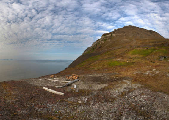
Grumantbyen is situated in a steep valley near the shore, under steep slopes.
The terrain was a source of frequent difficulties.
Panoramas
- Grumantbyen
- Eastern end of railway
- Memorial
- Railway track, tanks or boilers
- Railway track, mine entrance
- Railway track, mine entrance
- Central area
- Building (inside)
- Western building (entrance)
- Western building (inside)
- View over Grumantbyen
Panorama 1 – Grumantbyen
- pano anchor link: #200806_Grumantbyen_037_HDR
1912 and following years: Grumant – The trading house A.G. Agafeloff & Co
Several expeditions were sent out from Russia to investigate and secure coal occurrences in Spitsbergen from 1912. The first one was led by Vladimir Rusanov, but he disappeared later during the same summer together with the expedition ship, the Herkules, and most of the other expedition members in the northeast passage. But Rudolf L. Samoilowitsch and two other members had left the expedition in Spitsbergen. They returned safely with at least some results of their work. Samoilowitsch became a leading figure of Russian arctic research and he led the Russian expeditions to Spitsbergen until 1915. Based on the work done in 1912, he secured several areas, including Colesbukta and the coast of Isfjord to the east, where Grumant (Grumantbyen) was later established. The trading house A.G. Agafeloff & Co, founded by merchants in in Arkhangelsk, was the driving force behind these activities.

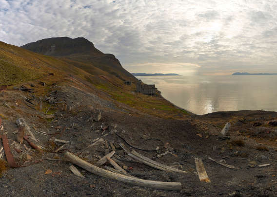
Access to Grumantbyen from the sea is limited by the steep and exposed shore to periods with good conditions.
There is a lot of dangerous scrap metal in the shallow water near the shore.
But the Russian activities in Spitsbergen ceased after 1915. See The early years of Barentsburg, Colesbukta/Grumant and Pyramiden for further details about these early years.
Panorama 2 – Eastern end of railway
- pano anchor link: #200806_Grumantbyen_056_HDR
From 1920 onwards: The Anglo Russian Grumant (ARG)
In 1920, the Anglo Russian Grumant Company Ltd was founded in London. The director, mining ingenieur Gregory Mikhailovitsj Nachimson, had been partner in the trading house Grumant – A.G. Agafeloff & Co since 1918 and knew their claims in Spitsbergen. It appears plausible that he wanted to secure the claims by moving the rights from Russia, where revolution and collectivisation were posing potential threats against the company’s interests, to a country that he felt was better suited to take care of the business. But this is only speculation. In any case, the ARG sent a first expedition with 21 members in 1920. A house was soon built on the Isfjord coast in Grumantdalen to the east of the river to provide accommodation and technical infrastructure was established to the west of the river: a power station (diesel), coal storage, pier and a railway track to the mining area. The first coal was already mined in 1920 at a seam that cropped out at 35 metres above sea level on the west side of the valley. 2000 tons of coal were shipped during that first year, and the settlement was developed further until 1925.
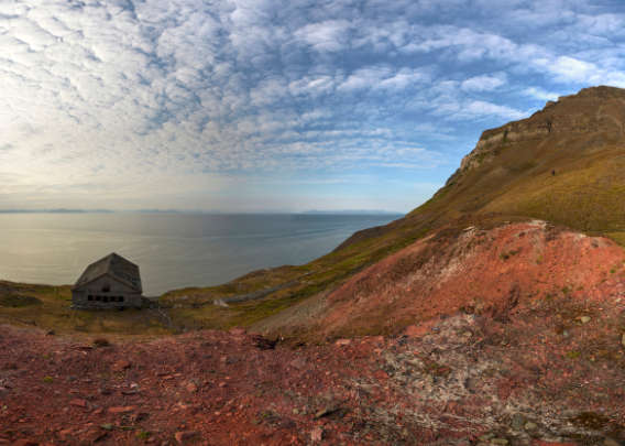
Panorama 3 – Memorial
A little memorial south of the settlement area. The background is unknown.
- pano anchor link: #200806_Grumantbyen_075_HDR

Information is scarse, but a few numbers may give an idea of the scale of the activities, which were continuous and productive for a couple of years, although not on a very large scale:
| Population (total) | Women/children | Coal production (tons) | Shipped coal (tons) | |
| Summer 1920 | 21 | 2000 | 2000 | |
| Winter 1920-21 | 38 | -/- | ||
| Summer 1921 | 45 | ? | 7000 | |
| Winter 1921-22 | 22 | -/- | ||
| Summer 1922 | 20 | ? | ? | |
| Winter 1922-23 | ? | -/- | ||
| Summer 1923 | 20 | 0 | ? | |
| Winter 1923-24 | 25 | -/- | ||
| Summer 1924 | 90 | ? | 16000 | |
| Winter 1924-25 | 66 | -/- | ||
| Summer 1925 | ? | 20200 | ? | |
| Winter 1925-26 | 42 | -/- | ||
| Summer 1926 | Gut 80 | 9000 | ? | |
| Winter 1926-27 | Nur Wachmannschaft | -/- | ||
| Summer 1927 | 6 | ? |
The production is given, as far as at all available, as annual production, without any further reference to summer or winter production. There was no shipping in winter. Data from Hoel (1966): Svalbards historie.
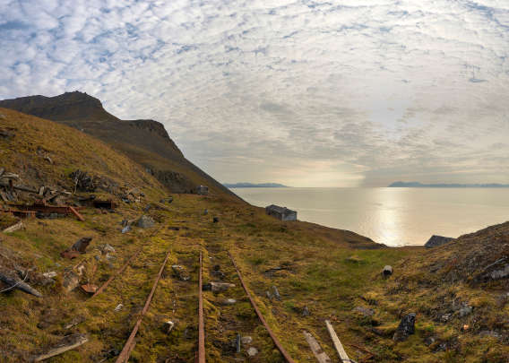
Panorama 4 – Railway track, tanks or boilers
- pano anchor link: #200806_Grumantbyen_094_HDR
Activities in 1923 concentrated on the infrastructure, and for a while there was no coal production.
Data are not complete, but the total production from 1920 to 1924 appears to have been 33,000 tons, while the capital used amounted to 90,000 Pound sterling during the same period.
1926 and following years: the end of the Anglo Russian Grumant
The collapse of coal prices on the world market in the middle of the 1920s brought mining companies in Spitsbergen and elsewhere into difficulties. The ARG was not able to continue her operations beyond 1925. Only a small group wintered in 1926-27 to guard the property, and 6 people where in Grumant in the summer of 1927 for some basic work: a manager, a cook, a foreman and 3 miners. In late 1927, the ARG was forced to terminate all operations in Spitsbergen and to sell the property and the rights. 62,000 tons of coal had been produced until then.
Panorama 5 – Railway track, mine entrance
- pano anchor link: #200806_Grumantbyen_113_HDR
1931 and following years: the Russian era begins – first Sojusljesprom, then Trust Arktikugol
In the summer of 1931, the Russian company Sojusljesprom started mining on the Grumant field. The icebreaker Sibiriakoff arrived on 12 July from Arkangelsk with 80 people, including 12 women. Most of the workers came from the coal mines in the Donezk area in the Ukraine and they were well paid (NOK 300,-/month, with free accommodation and food).

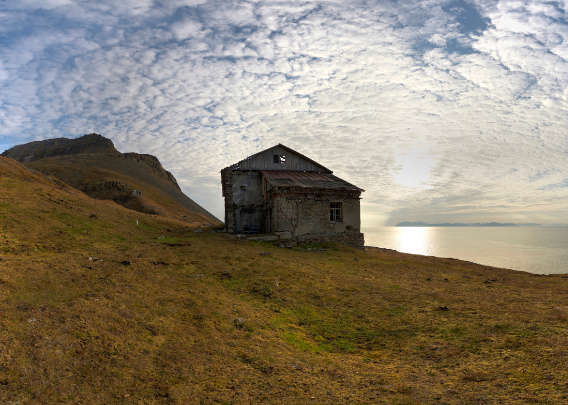
View over Grumant as it was in 2020.
The workers started immediately to build several houses, including two buildings with accommodation. Due to the difficult harbour conditions on the exposed coast, a plan existed from the beginning to use Colesbukta for shipping.
Another 117 workers, with 10 women amongst them, arrived at Colesbukta/Grumant in late July. Soon, accommodation and a radio station were built. Two baracks were ready at the end of the summer with enough space in each to house 100 people, and a club house and a hospital. Extensive work still had to be done before production could be resumed in the mine.

Old tank/boiler (?) behind the buildings.
The immediate commencement of the works by Sojusljesprom is remarkable, because it was formally still the ARG Ltd. who held the rights to the Grumant coal field. On 17 November 1931, these rights were taken over by the Trust Arktikugol, a Russian state-owned company that was developing coal and other geological resources on Russia’s north coast.
Panorama 6 – Railway track, mine entrance
- pano anchor link: #200806_Grumantbyen_132_HDR

1931 and following years: building and mining
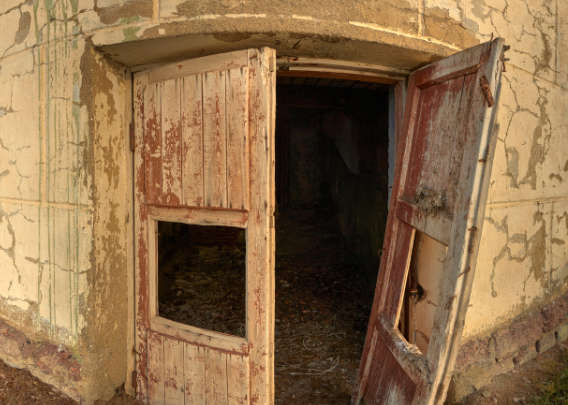
Not much is known about the operations in Colesbukta/Grumant in 1931 and the following years. There is some data given by Adolf Hoel in his 3 volume standard work Svalbards Historie. Hoel (15 May 1879 – 19 February 1964) had good access to anything available in Norway during his times, but for the Russian operations, all he had were the more or less annual reports from the inspections of the Norwegian Bergmester (Norwegian Directorate of Mining) who was the legal authority for all mining, regardless of nationality, in Spitsbergen. The Bergmester visited all relevant mines on an annual basis as much as possible. Hence, we know at least that the Trust Arktikugol put a lot of resources into the activities in Spitsbergen, especially Barentsburg and Grumant, straightaway. The Trust calculated with an annual production of 120,000 tons. Until 1962, Grumant was far more important for the Trust Arktikugol than Pyramiden, at least judged by population and coal production. Considering these key figures, the double settlement of Grumant/Colesbukta was also ahead of Barentsburg in some years.

Entrance to the building furthest west in Grumant.
As the sources are scarse and not easily available, I want to reproduce those data that are available here.
| Population | Thereof women/children | Coal production (tons) | Coal shipped (tons) | |
| Winter 1931-32 | ? | ? | 10000 | |
| Summer 1932 | 225 | ? | ? | |
| Winter 1932-33 | ? | 17011 | ||
| Summer 1933 | ? | ? | 0 (Betriebsstop) | ? |
| Winter 1933-34 | 230 | ? | 38643 | |
| Winter 1934-35 | 190 Bergarbeiter | ? | ||
| Summer 1935 | 312 | 55/7 | 50505 | 41462 |
| Winter 1935-36 | 350 | ? | ? | |
| Summer 1936 | 300 | ? | 75131 | 63909 |
| Summer 1937 | 390 | 64/6 | 77749 | ? |
| Summer 1938 | 407 | 58/12 | 57984 | ? |
| Summer 1939 | 467 | 56/12 | ? | |
| Summer 1940 | 426 | 75/21 | ||
| Summer 1941 | 609 | ? |
Data taken from Hoel (1966): Svalbards historie.
Panorama 7 – Central area
- pano anchor link: #200806_Grumantbyen_151_HDR
The older buildings in Grumant were removed until 1932 and replaced with new ones that could accommodate up to 400 people. The summer of 1932 was used to work on the infrastructure. There was no plan to put great effort into harbour facilities at Grumant. Initially, coal was to be transported to ships out in the fjord by barges and the ideas was to use the harbour in Colesbukta later, but both that harbour and a reliable connection between Grumant and Colesbukta still had to be built.

The staircase in the westernmost building in Grumant
has obviously seen better times in the past.
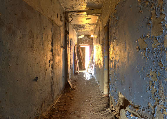
Operations in Grumant were temporarily ceased in 1933 because the terrain caused too many difficulties; the Trust hoped that coal occurrences in Colesbukta would turn out to be good enough to start mining from that end. At that time, infrastructure in Grumant was ready to supply 250 people with accommodation, power and everything else that was needed for a regular daily life, such as a club house, administration, radio station and diesel-based power station. Soon, mining was resumed again in Grumant.

Corridor in the westernmost building in Grumant.
190 miners and an unknown number of surface staff spent the winter of 1934-35 in Grumant. The number of people working on the surface was usually at least equal or even exceeded the number of those who actually worked in the mine. The proportion miners/total population was often near 1:3.
For comparison: 1447 people lived in Barentsburg during the winter of 1934-35, including 200 women.
Production work was going on at 2 coal seams, each with a thickness near 60 cm. They were separated by a sandstone layer which was also 60 cm thick. The production area was 18 metres below sea level. In 1937, work was started to prepare a new mine on the east side of the valley.

Old mine entrance.
A new power station had to be built in 1938 because the old one had burnt down after a short circuit on 14 December 1937. The Norwegian mining company Store Norske in Longyearbyen was able to supply two generators that dated back to the American times of Longyear City (until 1916) on a short notice. Without this delivery, all operations in Grumant would have come to a complete stop until at least the following summer, but as it was, the interruption was limited to 4 weeks. The new power station was equipped with a 300 kw diesel generator and it was enlarged in 1939. In the same year, a tunnel was built for the river in the settlement area to gain space for coal storage.
There is no information about the coal production of the individual Russian settlements in 1939, but a total of 313,246 tons was shipped (there was no production yet in Pyramiden, so the whole production was from Barentsburg and Grumant).
The second world did initially not influence the mining settlements in Spitsbergen.
In 1940, a two-storey building was raised on the west side of the Grumant valley. The mine on the west side of the valley was abandoned and coal production was moved to the east side of the valley. The production of the individual settlements in 1940 is not known, but 269,729 tons were shipped in total.
Panorama 8 – Building (inside)
- pano anchor link: #200806_Grumantbyen_246_HDR
1941 and following years: evacuation and destruction
The German attack on the Sovjet Union on 22 June 1941 was a major turning point for all settlements in Spitsbergen. All of them were evacuated and important infrastructure and coal reserves were destroyed against local protest. Work had continued in Grumant during the summer of 1941, but there was no shipping, so a lot of coal had been stored. 609 people were living in Grumant at that time: the largest population the place had had until then.
183,674 tons of coal were produced in the Russian mines in Spitsbergen in total in 1941 until 1 August, but only 109,414 tons were shipped. The settlements were evacuated in early September 1941. The inhabitants of Barentsburg, Colesbukta/Grumant and Pyramiden were taken to Arkhangelsk.

Grumant is divided into 2 parts by the river.
The German Kriegsmarine (navy) ran a large attack on Spitsbergen on 8 September 1943. Barentsburg was almost completely destroyed and only a few buildings remained in Grumant after that attack.
After the war: reconstruction from late 1946
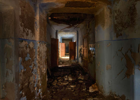
Reconstruction of the Russian settlements did not commence before November 1946. 120 people were busy to put Grumant back into operative mode again in the summer of 1947. Five smaller houses and one larger one were soon ready, but the mine was still destroyed. The workforce was raised up to 200 in autumn. Coal was desperately needed in northern Russia.

The easternmost building of those that were still standing in 2020 appeared so dangerous that I just took a photo through the window.
The Russian settlements had a total population of 1200 during the winter of 1947-48, but it is not known how this population was divided onto the individual places. Reconstruction work was still going on in Grumant in 1948, but large parts of the infrastructure were functional again, including a little hospital and the diesel power station, and coal production was taken up again. A pier and 4 houses had been built in Colesbukta, where geological investigations were carried out.
The little icebreaker Herkules sank with 25 souls on board in December 1948, probably during a storm near Bear Island (Bjørnøya). The Herkules had been stationed in Spitsbergen to provide transport between the settlements, and her loss must have been a heavy blow to the small communities.
Panorama 9 – Western building (entrance)
- pano anchor link: #200806_Grumantbyen_170_HDR
1949 and following years: routine operation
The rebuilding phase was completed in Grumant in 1949. There were large, two-storey wooden buildings for accommodation, a bath house with separate sections for women and men, administration, canteen, warm storage and hospital. The plan to build a cableway between Grumant and Colesbukta had been abandoned, but a way between the settlements had been completed. The population was near 600 people, 160-170 of which were working in the mine and 48 in Colesbukta. The number was increased up to 965 in the autumn of 1949. There was no mining in Colesbukta, but geological investigations were continued. There were 3 large buildings and a small one in Colesbukta, and a piggery, harbour and oil tanks.
The total population of the Russian settlements (Barentsburg, Colesbukta/Grumant, Pyramiden) in autumn 1949 was 2438 people, including 51 children. The total coal production was 125,000 tons, of which 105,466 were shipped.

Eastern end of the little railway in Grumant. From 1952, it was connected to Colesbukta.
In the winter of 1949-50, mining was continued east of the Grumant valley in a northerly direction, but geological faults which dislocated the rocks caused increasing difficulties. At the same time, work was done on a railway connection between Grumant and Colesbukta. this railway was almost finished in 1951, only 140 m of tunnel blasting remained to be done.
248.791 tons of coal were shipped from the Russian settlements in 1951. There are no further details regarding the production in the individual mines.

Steel scrap at the eastern end of the railway in Grumant.
In 1952, the Norwegian Bergmester (mining authority, see above) was denied access to the Russian mines for the first time, a new move in the relationships between Russians and and Norwegians, which was otherwise described as good and friendly by Hoel, based on the Bergmester’s reports.
The railway Colesbukta-Grumant was finally in operation, and the first loads of coal had been transported overland to Colesbukta to supply the power station over there. 40 minutes were needed for a distance of 8 kilometres; one train had 30 cars, each of which could take 3 tons of coal.
Panorama 10 – Western building (inside)
- pano anchor link: #200806_Grumantbyen_192_HDR
1954 and following years: difficulties with faults
It required a lot of effort in 1954-55 to build a way around a major geological fault (crack that displaces rocks) east of Grumant. These works were continued until 1958, but production was continued to the south and east at the same time. In 1958, production could finally be continued to the east of the fault.
A new house for accommodation was built in 1959. A new bath and laundry house and were in construction in 1959 and ready in 1960.

Ruins of houses in Grumant. It is difficult to identify individual buildings, but it is safe to say that all of these houses were built after the war.
1961-62: production stop and abandonment
Problems with geological faults and decreasing thickness and quality of the coal seams kept increasing in 1961. This led to a production stop in the autumn of 1961. This production stop was originally meant to be temporary as far as is known, but it marks the end of the Russian double settlement of Colesbukta and Grumant. 2054 people lived in the Russian settlements at that time. For comparison: the total population of all settlements in Spitsbergen was 2961. In other words, the Russian population represented by far the majority.
Colesbukta and Grumant were abandoned in 1962. According to the website of the Trust Arktikugol, the total production in Grumant amounts to 2 million tons.
| Population* | Thereof women/children | Coal production (tons) | Coal shipped (tons) | |
| Winter 1946-47 | ? | ? | ||
| Summer 1947 | 120 | |||
| Winter 1947-48 | 200 | ? | ||
| Summer 1948 | 450 | 50000 | ||
| Summer 1949 | 600, im Herbst 965 | |||
| Winter 1949-50 | 1008 | ?/5 | 116642 | |
| Summer 1951 | 1106 | ?/32 | ||
| Summer 1952 | 830 | ?/10 | 122107 | |
| Summer 1953 | 780 | ?/11 | ||
| Winter 1953-54 | 986 | ?/12 | 120459 | |
| Winter 1954-55 | 962 | ?/20 | 103210 | |
| Winter 1955-56 | 958 | ?/17 | 105287 | |
| Winter 1956-57 | 965 | ? | 93959 | |
| Summer 1958 | 1035 | ? | 73235 | |
| Summer 1959 | 1047 | ? | 128918 | |
| Summer 1960 | ? | ? | 125425 | |
| Winter 1960-61 | ? | ? | 73727 |
* Population of Grumant together with Colesbukta. Most people lived in Grumant, where the mines were located. Example: in 1949, 48 out of 600 people lived in Colesbukta and the others in Grumant.
Nothing is known for those years that are not mentioned, or just summarising data for all the Russian settlements together. These are mentioned in the text.
Data from Hoel (1966): Svalbards historie.
Panorama 11 – View over Grumantbyen
- pano anchor link: #200806_Grumantbyen_227_HDR

Adolf Hoel does not mention any accidents in Grumant or the other Russian settlements in Spitsbergen until 1965 in his book Svalbards Historie, which was finalised by others after his death in early 1964. In contrast, he highlighted the high technical standard of the Russian mines. There is no reason to assume that Hoel had any reason to describe the standards and accident history more favourable than it actually was. On the other hand, it is hard to imagine that there were never any accidents in the Russian coal mines, while there was a number of serious accidents, some with large loss of lives, in the Norwegian mines in Longyearbyen and Ny-Ålesund.
The Russian name of the former settlement, Grumant, is derived from the word Grumant, which the Pomors used for Spitsbergen. The word “Grumant” bears some similarity to “Greenland”. In the early years of its history, it was believed that Spitsbergen was a part of Greenland. Today, Grumant is mostly known as Grumantbyen, “byen” meaning “the town” in Norwegian (definite mode), as in Longyearbyen.
Source
The primary source was Alfred Hoel’s 3 volume standard work Svalbards Historie, here the chapter De Russiske Selskaper (Vol. I, pages 331-418). An elaborate book about the Russian history of Spitsbergen, written from an inside perspective on expert level, his lacking, as far as I can tell (and I did ask, more than once). There is still work to be done here for a Russian historian. Please don’t hesitate to let me know if you have more, relevant information.
BOOKS, CALENDAR, POSTCARDS AND MORE
This and other publishing products of the Spitsbergen publishing house in the Spitsbergen-Shop.
-

Norwegens arktischer Norden (1): Spitzbergen
Photobook: Norway's arctic islands. The text in this book is German. [shop url="https://shop.spitzbergen.de/en/polar-books/70-norwegens-arktischer-norden-1-aerial-arctic-9783937903262.html"] ← BackOrder now -
Norwegens arktischer Norden (2): Aerial Arctic
Lofoten, Jan Mayen and Spitsbergen from the air - Photobook: Norway's arctic islands. The text in this book is German, but there is very little text, so I am sure that you will enjoy it regardless which languages you read (or not).Order now -
Poster “Svalbardhytter”
The poster "Svalbardhytter" (70 x 100 cm) visualizes the diversity of Spitsbergen's huts in a range of arctic landscapes.Order now -
Book “Svalbardhytter”
The companion book for the Svalbardhytter poster. The poster visualises the diversity of Spitsbergen‘s huts and their stories in a range of Arctic landscapes. The book tells the stories of the huts in three languages.Order now -
Spitsbergen – Svalbard. The complete guidebook
Comprehensive guidebook about Spitsbergen. Background (wildlife, plants, geology, history etc.), practical information including travelling seasons, how to travel, description of settlements, routes and regions.Order now -
Rocks and Ice. Landscapes of the North
A geographical traveling accompaniment to Spitsbergen and East Greenland (68-74°N). This is the English edition of the German book "Steine und Eis".Order now -
East Greenland in Winter
Join an exciting journey with dog, skis and tent through the wintery wastes of East Greenland! We were five guys and a dog when we started in Ittoqqortoormiit, the northernmost one of two settlements on Greenland’s east coast.Order now -
Postcard set Spitsbergen (Svalbard)
12 Spitsbergen postcards in a beautifully designed tray. Individually numbered limited edition!Order now -
Limited edition postcard set Antarctica
12 postcards which come in a beautifully designed tray. Beautiful images from South Georgia across Antarctica from the Antarctic Peninsula to the Ross Sea and up to Macquarie Island and Campbell Island.Order now
last modification: 2025-03-15 ·
copyright: Rolf Stange


-
Books, Calendar, Postcards and more

-


