


-
current
recommendations- Liefdefjord
New page dedicated to one of Spitsbergen's most beautiful fjords. Background information and many photos.

- New Spitsbergen guidebook
The new edition of my Spitsbergen guidebook is out and available now!
- Liefdefjord
New page dedicated to one of Spitsbergen's most beautiful fjords. Background information and many photos.
-
weather information

| Guidebook: Spitsbergen-Svalbard |
Markhambreen
360 panorama of a dynamic high-arctic landscape

Markhambreen is located on Spitsbergen’s east coast in Storfjord.
Markhambreen is one of many glaciers on the south east coast of Spitsbergen. This wild coastal stretch is made up of steep mountains and many glaciers between them. In contrast to the west coast, there are no sheltered bays and fjords on this rather hostile coastal stretch.
- pano anchor link: #190708a_Markhambreen_001HDR
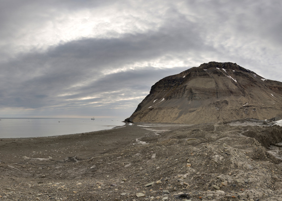
But the glaciers are retreating also here, giving way to small bays. This is the case for example in Isbukta, at Crollbreen or at Emil’janovbreen, all situated in this larger area, on the south east coast of Spitsbergen, at Storfjord.
- pano anchor link: #190708a_Markhambreen_033HDR
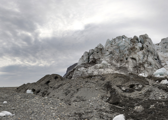
Also at Markhambreen, on aerial images taken in 2011 you can see a little bay between the glacier and a small, flat peninsula, not much more than a beach with a little lagoon, that has emerged from the retreating glacier. Assuming that meanwhile the glacier has retreated far enough to enable a safe landing on the inner, sheltered part of the beach, we went to have a look in 2019. But – surprise! After that aerial image was shot, the glacier has advanced again, so there is nothing left of that bay! The glacier is actually sitting on that beach peninsula, having created little push end moraines.
- pano anchor link: #190708a_Markhambreen_052HDR
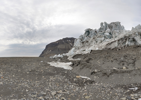
A fascinating example of recent landscape development in this high arctic setting!
BOOKS, CALENDAR, POSTCARDS AND MORE
This and other publishing products of the Spitsbergen publishing house in the Spitsbergen-Shop.
-

Norwegens arktischer Norden (1): Spitzbergen
Photobook: Norway's arctic islands. The text in this book is German. [shop url="https://shop.spitzbergen.de/en/polar-books/70-norwegens-arktischer-norden-1-aerial-arctic-9783937903262.html"] ← BackOrder now -
Norwegens arktischer Norden (2): Aerial Arctic
Lofoten, Jan Mayen and Spitsbergen from the air - Photobook: Norway's arctic islands. The text in this book is German, but there is very little text, so I am sure that you will enjoy it regardless which languages you read (or not).Order now -
Poster “Svalbardhytter”
The poster "Svalbardhytter" (70 x 100 cm) visualizes the diversity of Spitsbergen's huts in a range of arctic landscapes.Order now -
Book “Svalbardhytter”
The companion book for the Svalbardhytter poster. The poster visualises the diversity of Spitsbergen‘s huts and their stories in a range of Arctic landscapes. The book tells the stories of the huts in three languages.Order now -
Spitsbergen – Svalbard. The complete guidebook
Comprehensive guidebook about Spitsbergen. Background (wildlife, plants, geology, history etc.), practical information including travelling seasons, how to travel, description of settlements, routes and regions.Order now -
Rocks and Ice. Landscapes of the North
A geographical traveling accompaniment to Spitsbergen and East Greenland (68-74°N). This is the English edition of the German book "Steine und Eis".Order now -
East Greenland in Winter
Join an exciting journey with dog, skis and tent through the wintery wastes of East Greenland! We were five guys and a dog when we started in Ittoqqortoormiit, the northernmost one of two settlements on Greenland’s east coast.Order now -
Postcard set Spitsbergen (Svalbard)
12 Spitsbergen postcards in a beautifully designed tray. Individually numbered limited edition!Order now -
Limited edition postcard set Antarctica
12 postcards which come in a beautifully designed tray. Beautiful images from South Georgia across Antarctica from the Antarctic Peninsula to the Ross Sea and up to Macquarie Island and Campbell Island.Order now
last modification: 2024-12-12 ·
copyright: Rolf Stange


-
Books, Calendar, Postcards and more

-


