


-
current
recommendations- Liefdefjord
New page dedicated to one of Spitsbergen's most beautiful fjords. Background information and many photos.

- New Spitsbergen guidebook
The new edition of my Spitsbergen guidebook is out and available now!
- Liefdefjord
New page dedicated to one of Spitsbergen's most beautiful fjords. Background information and many photos.
-
weather information

| Guidebook: Spitsbergen-Svalbard |
Hiorthfjellet
An iconic mountain in Adventfjord opposite of Longyearbyen
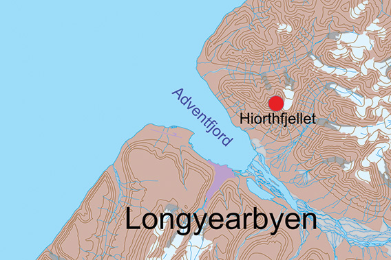
Hiorthfjellet is located on the north side of Adventfjord.
Hiorthfjellet is a prominent, almost iconic mountain on the north side of Adventfjord, opposite of Longyearbyen. It is the everyday stunning view that you have from town and a great destination, though challenging, for excellent hiking both summer and winter. In the summer, you need boat transfer to get there. In the winter, it is easier as the river and tundra in Adventdalen are frozen and snow-covered, so you can easily cross by ski or snow mobile. It is even possible to get several hundred metres up the slope of Hiorthfjellet, to the hut Telelinken which is easily seen with its huge antennas.
Hiorthfjellgruva, the old mine on Hiorthfjellet, has got two dedicated pages: Ørneredet and Sneheim.
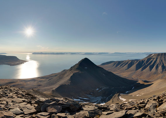
The first panorama is taken in an altitude of approximately 600 metres. This is where we start to ascend Hiorthfjellet proper. The way up is hard work 🥵 …
- pano anchor link: #a9p_Hiorthfjellet_23Aug14_259

… almost there 🙂
- pano anchor link: #a9p_Hiorthfjellet_23Aug14_218

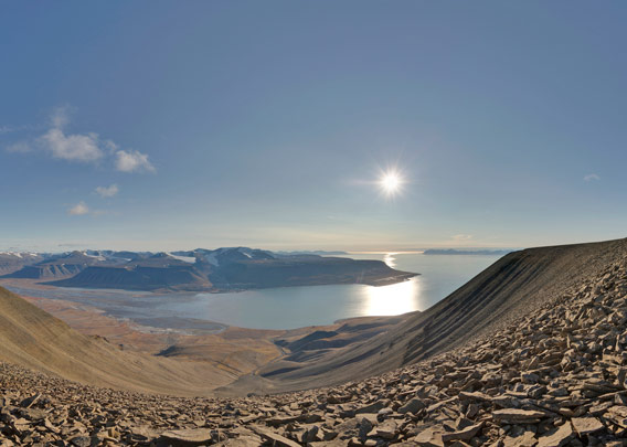
Here we have reached the western corner of the plateau that forms the mountain top of Hiorthfjellet.
- pano anchor link: #a9p_Hiorthfjellet_23Aug14_195
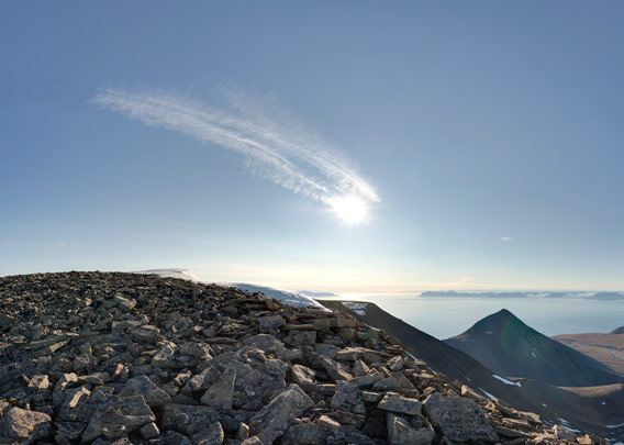
This panorama is located at the southeastern corner of the top plateau, with the view to the glacier Hiorthbreen on the north side of the ridge.
- pano anchor link: #a9p_Hiorthfjellet_23Aug14_176
Our next and last viewpoint is the northern corner of Hiorthfjellet’s top plateau, with a good view over Hanaskogdalen:
- pano anchor link: #a9p_Hiorthfjellet_23Aug14_095
BOOKS, CALENDAR, POSTCARDS AND MORE
This and other publishing products of the Spitsbergen publishing house in the Spitsbergen-Shop.
-

Norwegens arktischer Norden (1): Spitzbergen
Photobook: Norway's arctic islands. The text in this book is German. [shop url="https://shop.spitzbergen.de/en/polar-books/70-norwegens-arktischer-norden-1-aerial-arctic-9783937903262.html"] ← BackOrder now -
Norwegens arktischer Norden (2): Aerial Arctic
Lofoten, Jan Mayen and Spitsbergen from the air - Photobook: Norway's arctic islands. The text in this book is German, but there is very little text, so I am sure that you will enjoy it regardless which languages you read (or not).Order now -
Poster “Svalbardhytter”
The poster "Svalbardhytter" (70 x 100 cm) visualizes the diversity of Spitsbergen's huts in a range of arctic landscapes.Order now -
Book “Svalbardhytter”
The companion book for the Svalbardhytter poster. The poster visualises the diversity of Spitsbergen‘s huts and their stories in a range of Arctic landscapes. The book tells the stories of the huts in three languages.Order now -
Spitsbergen – Svalbard. The complete guidebook
Comprehensive guidebook about Spitsbergen. Background (wildlife, plants, geology, history etc.), practical information including travelling seasons, how to travel, description of settlements, routes and regions.Order now -
Rocks and Ice. Landscapes of the North
A geographical traveling accompaniment to Spitsbergen and East Greenland (68-74°N). This is the English edition of the German book "Steine und Eis".Order now -
East Greenland in Winter
Join an exciting journey with dog, skis and tent through the wintery wastes of East Greenland! We were five guys and a dog when we started in Ittoqqortoormiit, the northernmost one of two settlements on Greenland’s east coast.Order now -
Postcard set Spitsbergen (Svalbard)
12 Spitsbergen postcards in a beautifully designed tray. Individually numbered limited edition!Order now -
Limited edition postcard set Antarctica
12 postcards which come in a beautifully designed tray. Beautiful images from South Georgia across Antarctica from the Antarctic Peninsula to the Ross Sea and up to Macquarie Island and Campbell Island.Order now
last modification: 2025-02-14 ·
copyright: Rolf Stange


-
Books, Calendar, Postcards and more

-


