


-
current
recommendations- Liefdefjord
New page dedicated to one of Spitsbergen's most beautiful fjords. Background information and many photos.

- New Spitsbergen guidebook
The new edition of my Spitsbergen guidebook is out and available now!
- Liefdefjord
New page dedicated to one of Spitsbergen's most beautiful fjords. Background information and many photos.
-
weather information

| Guidebook: Spitsbergen-Svalbard |
Signehamna
360°-Panoramen
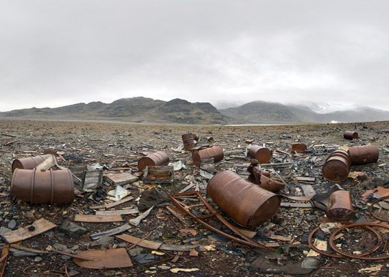
First a 360 degree view from Signehamna im Lilliehöökfjord, the western inner branch in Krossfjord. We are standing next to the remains of two German weather stations from the dark times of the Second World War. Weather data were of high importance then for military operations, and as no civilian network of meteorological stations was available anymore, the German military strived to get their own data from the north Atlantic, where much of the weather of northwestern Europe is coming from.
In autumn 1941, the German Kriegsmarine (navy) established a weather station called “Knospe” (“bud”, after the station leader, whose name was Knoespel), where 6 men wintered. In 1942-43, “Nussbaum” followed (“nut tree”, after station commander Nusser). In June 1943, shortly before “Nussbaum” was picked up again, a group of Norwegian soldiers discovered the German presence in Signehamna. Shots were fired, and one German died. The submarine that soon came to pick the Germans up discovered the Norwegian boat in Nilspollen, the small bay directly south of Signehamna, and opened fire. The boat sank, and one Norwegian drowned during his attempt to reach the shore. Bloody war events in the seemingly pristine arctic surroundings of Krossfjord.
- pano anchor link: #spitzbergen_005
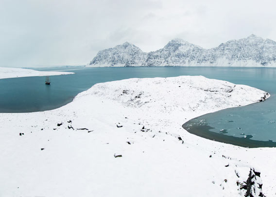
Two more panoramic views (not 360 degrees) of Signehamna in Lilliehöökfjord. In late September 2012, winter had already moved in.
- pano anchor link: #spitsbergen_004

- pano anchor link: #spitsbergen_005
BOOKS, CALENDAR, POSTCARDS AND MORE
This and other publishing products of the Spitsbergen publishing house in the Spitsbergen-Shop.
-

Norwegens arktischer Norden (1): Spitzbergen
Photobook: Norway's arctic islands. The text in this book is German. [shop url="https://shop.spitzbergen.de/en/polar-books/70-norwegens-arktischer-norden-1-aerial-arctic-9783937903262.html"] ← BackOrder now -
Norwegens arktischer Norden (2): Aerial Arctic
Lofoten, Jan Mayen and Spitsbergen from the air - Photobook: Norway's arctic islands. The text in this book is German, but there is very little text, so I am sure that you will enjoy it regardless which languages you read (or not).Order now -
Poster “Svalbardhytter”
The poster "Svalbardhytter" (70 x 100 cm) visualizes the diversity of Spitsbergen's huts in a range of arctic landscapes.Order now -
Book “Svalbardhytter”
The companion book for the Svalbardhytter poster. The poster visualises the diversity of Spitsbergen‘s huts and their stories in a range of Arctic landscapes. The book tells the stories of the huts in three languages.Order now -
Spitsbergen – Svalbard. The complete guidebook
Comprehensive guidebook about Spitsbergen. Background (wildlife, plants, geology, history etc.), practical information including travelling seasons, how to travel, description of settlements, routes and regions.Order now -
Rocks and Ice. Landscapes of the North
A geographical traveling accompaniment to Spitsbergen and East Greenland (68-74°N). This is the English edition of the German book "Steine und Eis".Order now -
East Greenland in Winter
Join an exciting journey with dog, skis and tent through the wintery wastes of East Greenland! We were five guys and a dog when we started in Ittoqqortoormiit, the northernmost one of two settlements on Greenland’s east coast.Order now -
Postcard set Spitsbergen (Svalbard)
12 Spitsbergen postcards in a beautifully designed tray. Individually numbered limited edition!Order now -
Limited edition postcard set Antarctica
12 postcards which come in a beautifully designed tray. Beautiful images from South Georgia across Antarctica from the Antarctic Peninsula to the Ross Sea and up to Macquarie Island and Campbell Island.Order now
last modification: 2017-12-23 ·
copyright: Rolf Stange


-
Books, Calendar, Postcards and more

-


