


-
current
recommendations- Liefdefjord
New page dedicated to one of Spitsbergen's most beautiful fjords. Background information and many photos.

- New Spitsbergen guidebook
The new edition of my Spitsbergen guidebook is out and available now!
- Liefdefjord
New page dedicated to one of Spitsbergen's most beautiful fjords. Background information and many photos.
-
weather information

| Guidebook: Spitsbergen-Svalbard |
Sassenfjord
Nature and history in inner Isfjord

Sassenfjord and Tempelfjord are located in inner Isfjord, north-east of Longyearbyen.
General information
Sassenfjord is often perceived together with Tempelfjord as one continuous branch of the fjord. There is of course some truth to this, as a glance at the map makes clear, but Sassenfjord can also be interpreted geomorphologically as an extension of the valley of Sassendalen. This is why it has got a separate name to distinguish it from adjoining Tempelfjord and because both are so large and varied, each has its own page so that it remains reasonably clear despite the many pictures.

View of Sassenfjord from Deltaneset.
Geology
On the north side, around Gipsdalen, deposits from the late Palaeozoic (Carboniferous and Permian, upper Palaeozoic) dominate. More on this on the page on the neighbouring Tempelfjord, for example, which share a lot of the geology.
On the southern side, the Triassic is found all over the place with its dark claystones and siltstones: 200 million year old deposits from shelf seas that could be compared to today’s North Sea. Fossils such as ammonites and shells can be found in these rocks. Bones of marine dinosaurs (plesiosaurs, pliosaurs) have also been found in sediments from the Triassic in the Sassenfjord and can be seen today in the Natural History Museum in Oslo.
On the Gipshuken-Vindodden line in inner Sassenfjord runs the Billefjorden fault zone, a large geological fault zone that was active a long time ago, before the Triassic sediments were deposited. The last movements also took place in the Mesozoic era (Triassic, Jurassic, Cretaceous), so that sediments from the Carboniferous period and even younger ones are still partially deformed. You can see the resulting folds and faults in the slopes east of Vindodden. Other impressive examples are in Billefjord (Gipshuken and northwest of Petuniabukta) and further south in Nordenskiöld Land (Fleksurfjellet in inner Adventdalen)
The matter is simpler than it may seem at first: rocks must first exist before they can be deformed (folded). If you see a fold or a fault in the layers, then the movement that led to this deformation took place after the layers were deposited. It doesn’t work the other way round.

Impressions of shells from the Triassic at Deltaneset in the outer Sassenfjord.
On the south side of the Sassenfjord there are also basaltic intrusions of diabase (also known as hyperite or dolerite), a rock similar to basalt. However, the columns formation in diabase is much coarser than in basalt; there are no such beautiful basalt columns as in Iceland in the diabase of Svalbard. The rock that gave Diabasodden and Hyperittfossen (a nearby waterfall) in Sassenfjord their names is the same as at Alkefjellet in Hinlopen Strait, to name just one well-known example.
A few impressions of Deltaneset in the outer Sassenfjord, where you are in the right place if you are interested in geology (and more):
- gallery anchor link: #gallery_3450
Click on thumbnail to open an enlarged version of the specific photo.


Due to its relative hardness, the diabase often forms ledges and steep steps in the terrain. At Diabasodden (‘Diabas headland’), a colony of seabirds, especially Brünich’s guillemots, black guillemots and a few puffins, benefit from the steep basalt cliffs, and in De Geerdalen, Hyperitfossen, a beautiful little waterfall, falls over a steep step caused by a basaltic intrusion (geese breed on top of the cliffs, so keep a good distance during the breeding season).

Diabase at Hyperittfossen at Elveneset (wide-angle shot).
Landscape
On the north side, the view is dominated by the beautiful mountain Templet and directly neighbouring the large valley of Gipsdalen.
On the south side, the slopes are less steep and there are also flat areas of green tundra at Diabasodden and De Geerdalen.

View over Elveneset and the frozen Sassenfjord to Templet.
Today, Sassenfjord rarely freezes over.
Flora and fauna
There are several bird cliffs on steep cliffs, with Diabasodden on the south side of Sassenfjord being particularly beautiful, partly because it is quite accessible. In addition to Brünich’s guillemots, a few puffins and black guillemots also breed there, as well as geese on the top of the cliffs. Appropriate caution is required during the breeding season.
There are many foxes in the area and reindeer are numerous in the tundra areas. And if you think there are no polar bears this close to Longyearbyen, you are in for a creamy white surprise.
A few pictures of the flora and fauna in Sassenfjord:
- gallery anchor link: #gallery_3453
Click on thumbnail to open an enlarged version of the specific photo.


History
The Pomors knew Sassenfjord, but it is the trapper Hilmar Nøis who is still prominently associated with the area today. He was known as the “king of Sassenfjord” (or Sassendalen or Tempelfjord, for that sake). He had several huts in Sassenfjord, for example on Gipshuksletta and Elveneset (the latter no longer exists). His main hut was Fredheim in Tempelfjord.
Sassenfjord: Diabasodden, Elveneset/Hyperittfossen
These places are not right next to each other, but close enough to walk between them. Beautiful hikes!
I have very fond memories of Diabasodden, which was one of my very first Spitsbergen experiences. It was there that I made friends and experienced a landscape for life, learnt for the first time that a Brünich’s guillemot is different from a black guillemot and that mountain avens is different from a Svalbard poppy and so on. Oh yes, the first polar bear you see in the wild is something you never forget … especially when it’s ‘at night’ (it wasn’t dark) right in front of the tent! Or what do you think, Claus? We certainly won’t forget it as long as our heads are still working 🙂
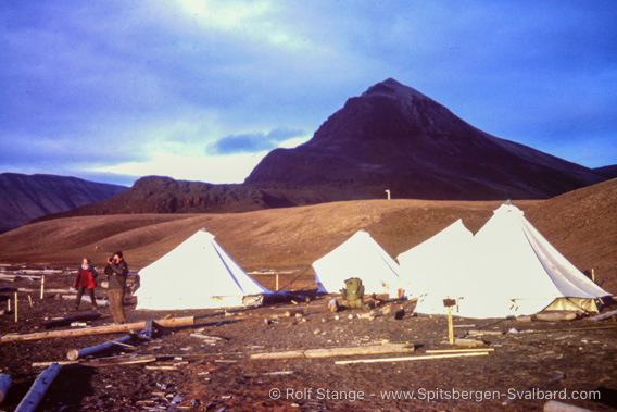
Diabasodden, with Ursel and Claus (1997).
In this triangle between Diabasodden and lower De Geerdalen (Hyperittfossen, Elveneset) there is so much of what makes Spitsbergen beautiful and interesting. The seabird colony in Diabasodden. The tundra in De Geerdalen, the Hyperittfossen waterfall at Elveneset (lower De Geerdalen). The mountains with their hikes, views, fossils …
- gallery anchor link: #gallery_3426
Click on thumbnail to open an enlarged version of the specific photo.


Photo gallery Sassenfjord
A few more assorted impressions from Sassenfjord.
- gallery anchor link: #gallery_3435
Click on thumbnail to open an enlarged version of the specific photo.


BOOKS, CALENDAR, POSTCARDS AND MORE
This and other publishing products of the Spitsbergen publishing house in the Spitsbergen-Shop.
-

Norwegens arktischer Norden (1): Spitzbergen
Photobook: Norway's arctic islands. The text in this book is German. [shop url="https://shop.spitzbergen.de/en/polar-books/70-norwegens-arktischer-norden-1-aerial-arctic-9783937903262.html"] ← BackOrder now -
Norwegens arktischer Norden (2): Aerial Arctic
Lofoten, Jan Mayen and Spitsbergen from the air - Photobook: Norway's arctic islands. The text in this book is German, but there is very little text, so I am sure that you will enjoy it regardless which languages you read (or not).Order now -
Poster “Svalbardhytter”
The poster "Svalbardhytter" (70 x 100 cm) visualizes the diversity of Spitsbergen's huts in a range of arctic landscapes.Order now -
Book “Svalbardhytter”
The companion book for the Svalbardhytter poster. The poster visualises the diversity of Spitsbergen‘s huts and their stories in a range of Arctic landscapes. The book tells the stories of the huts in three languages.Order now -
Spitsbergen – Svalbard. The complete guidebook
Comprehensive guidebook about Spitsbergen. Background (wildlife, plants, geology, history etc.), practical information including travelling seasons, how to travel, description of settlements, routes and regions.Order now -
Rocks and Ice. Landscapes of the North
A geographical traveling accompaniment to Spitsbergen and East Greenland (68-74°N). This is the English edition of the German book "Steine und Eis".Order now -
East Greenland in Winter
Join an exciting journey with dog, skis and tent through the wintery wastes of East Greenland! We were five guys and a dog when we started in Ittoqqortoormiit, the northernmost one of two settlements on Greenland’s east coast.Order now -
Postcard set Spitsbergen (Svalbard)
12 Spitsbergen postcards in a beautifully designed tray. Individually numbered limited edition!Order now -
Limited edition postcard set Antarctica
12 postcards which come in a beautifully designed tray. Beautiful images from South Georgia across Antarctica from the Antarctic Peninsula to the Ross Sea and up to Macquarie Island and Campbell Island.Order now
last modification: 2024-12-21 ·
copyright: Rolf Stange


-
Books, Calendar, Postcards and more

-


