-
current
recommendations- Liefdefjord
New page dedicated to one of Spitsbergen's most beautiful fjords. Background information and many photos.

- New Spitsbergen guidebook
The new edition of my Spitsbergen guidebook is out and available now!

- Liefdefjord
New page dedicated to one of Spitsbergen's most beautiful fjords. Background information and many photos.
Page Structure
-
Spitsbergen-News
- Select Month
- June 2025
- May 2025
- April 2025
- March 2025
- February 2025
- January 2025
- December 2024
- November 2024
- October 2024
- September 2024
- August 2024
- July 2024
- June 2024
- May 2024
- April 2024
- March 2024
- February 2024
- January 2024
- December 2023
- November 2023
- October 2023
- September 2023
- August 2023
- July 2023
- June 2023
- May 2023
- April 2023
- March 2023
- February 2023
- January 2023
- December 2022
- November 2022
- October 2022
- September 2022
- August 2022
- July 2022
- June 2022
- May 2022
- April 2022
- March 2022
- February 2022
- January 2022
- December 2021
- November 2021
- October 2021
- September 2021
- August 2021
- July 2021
- June 2021
- May 2021
- April 2021
- March 2021
- February 2021
- January 2021
- December 2020
- November 2020
- October 2020
- September 2020
- August 2020
- July 2020
- June 2020
- May 2020
- April 2020
- March 2020
- February 2020
- January 2020
- December 2019
- November 2019
- October 2019
- September 2019
- August 2019
- July 2019
- June 2019
- May 2019
- April 2019
- March 2019
- February 2019
- January 2019
- December 2018
- November 2018
- October 2018
- September 2018
- August 2018
- July 2018
- June 2018
- May 2018
- April 2018
- March 2018
- February 2018
- January 2018
- December 2017
- November 2017
- October 2017
- September 2017
- August 2017
- July 2017
- June 2017
- May 2017
- April 2017
- March 2017
- February 2017
- January 2017
- December 2016
- November 2016
- October 2016
- September 2016
- August 2016
- July 2016
- June 2016
- May 2016
- April 2016
- March 2016
- February 2016
- January 2016
- December 2015
- November 2015
- October 2015
- September 2015
- August 2015
- July 2015
- June 2015
- May 2015
- April 2015
- March 2015
- February 2015
- January 2015
- December 2014
- November 2014
- October 2014
- September 2014
- August 2014
- July 2014
- June 2014
- May 2014
- April 2014
- March 2014
- February 2014
- January 2014
- December 2013
- November 2013
- October 2013
- September 2013
- August 2013
- July 2013
- June 2013
- May 2013
- April 2013
- March 2013
- February 2013
- January 2013
- December 2012
- November 2012
- October 2012
- September 2012
- August 2012
- July 2012
- June 2012
- May 2012
- April 2012
- March 2012
- February 2012
- January 2012
- December 2011
- November 2011
- October 2011
- September 2011
- August 2011
- May 2011
- April 2011
- March 2011
- February 2011
- January 2011
- December 2010
- November 2010
- September 2010
- August 2010
- July 2010
- June 2010
- May 2010
- April 2010
- March 2010
- February 2010
- November 2009
- October 2009
- August 2009
- July 2009
- June 2009
- May 2009
- April 2009
- March 2009
- February 2009
- January 2009
- December 2008
- November 2008
- October 2008
- August 2008
- July 2008
- June 2008
- May 2008
- April 2008
- March 2008
- February 2008
- April 2000
- Select Month
-
weather information
-
Newsletter

| Guidebook: Spitsbergen-Svalbard |
17th century whaling
History of Spitsbergen
17th century whaling

Both the survivors of Barentsz’ expedition as well as other explorers such as Henry Hudson brought home with them the tales of the rich whaling grounds of the arctic seas. It took only a few years until the first whalers of several European nations, most importantly England and Holland, sailed up to Spitsbergen. The English were the first ones, but focused on Walrus rather than whales during the very first seasons. Back then, Walrus were abundant at the west coast of Spitsbergen and even on Bjørnøya, where hundreds of them were slaughtered. Dutch entrepeneurs did not waste a lot of time until they sent the first expeditions in the wake of the English ones.
In the first years, everybody had Basque whaling masters on board to learn how to hunt the large marine mammals. Soon, a number of shore stations was established. These were needed to process the whale and to boil the blubber (fat) down into oil. Whale oil could be sold for good money in Europe and was used as lamp oil, to make soap, as lubrication and for other purposes. Also the baleen could be sold for umbrellas, female fashion etc. By far the most important target species was the Bowhead whale (Baleana mysticetus), also called the ‘Right Whale’. It was the ‘right whale to hunt’, because it had a thick layer of blubber, swam slowly and stayed at the surface also when it was dead.
The Bowhead whale, the most important target species for 17th century whaling

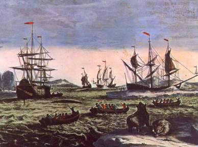
Hunting itself was done from small, open boats. Whenever a whale was seen, boats were launched and rowed out to the whale. The harponeer hand-threw his weapon to the whale, which was finally killed with a lance. The whale was then pulled to the shore station, where it was cut into pieces (‘flensed’) on the shore. The blubber pieces were then boiled down to oil, the rest was not used in the early decades of whaling.
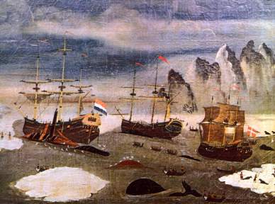
17th century whaling ships
A number of shore stations was soon established both on Spitsbergen and Jan Mayen, and competition for good whaling grounds and places for stations grew. There were armed conflicts, which made the company of warships necessary. In 1693, the northernmost sea battle ever took place in the Sorgfjord, when three French warships captured about 40 Dutch whalers, several of which escaped.
But in these years, the late 17th century, the busy years of whaling in the waters near Spitsbergen’s shorelines were already gone. The shore stations, including the famous Smeerenburg (‘Blubber town’) on Amsterdamøya in northwestern Spitsbergen, had their heydays in the 1630s. In those days, the territory on land and at sea had been devided between the two most important whaling nations England and Holland. Additionally, Danes, French, Spaniards and Germans had established their stations. The size of the shore stations had for a long time been strongly exaggerated in literature, until Dutch excavations of Smeerenburg showed that there were never more than a few 100 people working at a station at one time. Rumours of churches, internet cafes and brothels, frequented by more than 10 000 workers, are nothing but legends. Nevertheless, remains of blubber ovns and graves can still be seen in many places.
Remains of blubber ovns at Smeerenburg (Amsterdamøya)
These places were in use only during the summer season. After plundering, a wintering was attempted by the Dutch to protect the important facilities. In 1633, a small party of seven men was left at Smeerenburg and another seven in Kvalrossbukta on Jan Mayen. The latter ones died, whereas the brave whalers at Smeerenburg survived. Another wintering party was left again at Smeerenburg in 1634; this time all seven perished.
After a few decades, the land stations were abandoned, as the whales which had frequented the fjords of Spitsbergen so abundantly only a short while ago, became very scarce, and advancing technology allowed to process the whales at sea.
BOOKS, CALENDAR, POSTCARDS AND MORE
This and other publishing products of the Spitsbergen publishing house in the Spitsbergen-Shop.
last modification: 2019-03-02 ·
copyright: Rolf Stange


