-
current
recommendations- Liefdefjord
New page dedicated to one of Spitsbergen's most beautiful fjords. Background information and many photos.
- New Spitsbergen guidebook
The new edition of my Spitsbergen guidebook is out and available now!
- Liefdefjord
New page dedicated to one of Spitsbergen's most beautiful fjords. Background information and many photos.
Page Structure
-
Spitsbergen-News
- Select Month
- June 2025
- May 2025
- April 2025
- March 2025
- February 2025
- January 2025
- December 2024
- November 2024
- October 2024
- September 2024
- August 2024
- July 2024
- June 2024
- May 2024
- April 2024
- March 2024
- February 2024
- January 2024
- December 2023
- November 2023
- October 2023
- September 2023
- August 2023
- July 2023
- June 2023
- May 2023
- April 2023
- March 2023
- February 2023
- January 2023
- December 2022
- November 2022
- October 2022
- September 2022
- August 2022
- July 2022
- June 2022
- May 2022
- April 2022
- March 2022
- February 2022
- January 2022
- December 2021
- November 2021
- October 2021
- September 2021
- August 2021
- July 2021
- June 2021
- May 2021
- April 2021
- March 2021
- February 2021
- January 2021
- December 2020
- November 2020
- October 2020
- September 2020
- August 2020
- July 2020
- June 2020
- May 2020
- April 2020
- March 2020
- February 2020
- January 2020
- December 2019
- November 2019
- October 2019
- September 2019
- August 2019
- July 2019
- June 2019
- May 2019
- April 2019
- March 2019
- February 2019
- January 2019
- December 2018
- November 2018
- October 2018
- September 2018
- August 2018
- July 2018
- June 2018
- May 2018
- April 2018
- March 2018
- February 2018
- January 2018
- December 2017
- November 2017
- October 2017
- September 2017
- August 2017
- July 2017
- June 2017
- May 2017
- April 2017
- March 2017
- February 2017
- January 2017
- December 2016
- November 2016
- October 2016
- September 2016
- August 2016
- July 2016
- June 2016
- May 2016
- April 2016
- March 2016
- February 2016
- January 2016
- December 2015
- November 2015
- October 2015
- September 2015
- August 2015
- July 2015
- June 2015
- May 2015
- April 2015
- March 2015
- February 2015
- January 2015
- December 2014
- November 2014
- October 2014
- September 2014
- August 2014
- July 2014
- June 2014
- May 2014
- April 2014
- March 2014
- February 2014
- January 2014
- December 2013
- November 2013
- October 2013
- September 2013
- August 2013
- July 2013
- June 2013
- May 2013
- April 2013
- March 2013
- February 2013
- January 2013
- December 2012
- November 2012
- October 2012
- September 2012
- August 2012
- July 2012
- June 2012
- May 2012
- April 2012
- March 2012
- February 2012
- January 2012
- December 2011
- November 2011
- October 2011
- September 2011
- August 2011
- May 2011
- April 2011
- March 2011
- February 2011
- January 2011
- December 2010
- November 2010
- September 2010
- August 2010
- July 2010
- June 2010
- May 2010
- April 2010
- March 2010
- February 2010
- November 2009
- October 2009
- August 2009
- July 2009
- June 2009
- May 2009
- April 2009
- March 2009
- February 2009
- January 2009
- December 2008
- November 2008
- October 2008
- August 2008
- July 2008
- June 2008
- May 2008
- April 2008
- March 2008
- February 2008
- April 2000
- Select Month
-
weather information
-
Newsletter

| Guidebook: Spitsbergen-Svalbard |
Home
→ December, 2017
Monthly Archives: December 2017 − News & Stories
2017: my year in review – February and March: the Antarctic Odyssey
After finishing the big project with my new Norwegian guidebook Svalbard – Norge nærmest Nordpolen, it was time to get some fresh air. And I got lots of it during a trip around the world in February in March. The heart of this huge voyage was a semi-circumnavigation of Antarctica, which I refer to as the “Antarctic Odyssey”. Starting in New Zealand, we went to Campbell Island, into the Ross Sea and then via Peter I Island to the Antarctic Peninsula before we finished in Ushuaia. Truly an Odyssey!
The highlight of this great journey? Hard to say. There was not only one highlight. Just the dimensions of this trip are epic, many thousand nautical miles in more than 30 days. Being Expedition Leader on such a trip on the Ortelius was certainly a contribution towards making it interesting for me. Normally, “my” ships are much smaller these days, and they do not carry 3 helicopters!
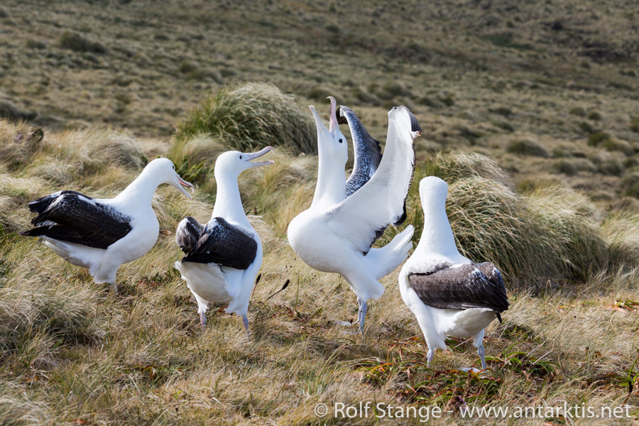
Thinking about which impression still means a lot to me and will stay for a long time, then Campbell Island is quickly coming to my mind. This island, which belongs to the New Zealand subantarctic islands, was very high on my personal wishlist – simply as I had not been there before. Well, I had been very close 2 years earlier, but then, there was no chance of making a landing because of very strong winds. This time, we had just the portion of luck that you need in a place like that.

Albatrosses on Campbell Island.
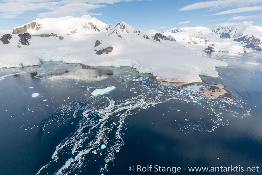
Of course, flying into Taylor Valley, one of the famous McMurdo Dry Valleys, and to McMurdo Base, where we almost stayed quite a bit longer than we actually wanted to, are experiences never to be forgotten. And that is generally true for all impressions of Antarctica from a bird’s perspective.

Waterboat Point (Antarctic Peninsula) from the air.
But in the end, it is the direct encounters with the wildlife and the scenery that is always getting very close to my heart and soul. That is what stays! The Albatrosses on Campbell Island, the Emperor penguins in the Ross Sea, the Humpback whales and penguins in the Antarctic peninsula, to mention a few of these encounters. Memories that will stay forever!

Emperor and Adelie penguin at Cape Hallet in the Ross Sea.
2017: my year in review
It is almost frightening how time is flying. Again, a year almost gone! It was an intense, rich year. What did the last 12 months bring, for Spitsbergen, for spitsbergen-svalbard.com and for me? I’ll review the year with a couple of blogs over the next days.
January is polar night in the far north. A good time for writing table adventures. Writing arctic books is not boring, but the actual process is often not terribly exciting. In practice, it means to spend an awful lot of time on the computer. Researching, writing, editing, looking for images, processing images, making illustrations and so on and so forth.
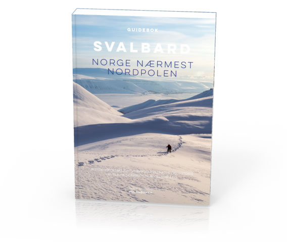
In January 2017, my biggest project in many years was about to be finished. I can tell you that it was not boring! For a long time already, I had had dreams of a Norwegian translation of my Spitsbergen guidebook. And in 2015, I was brave or crazy enough to go ahead with it. Intense work on every opportunity for a good year, involving a number of native speakers who helped me in translating and “språkvask” (proofreading language). I am still almost feeling dizzy when I bring these weeks and months, which were very intense, back to my inner eye. I don’t want to bother you with the details of the process, but it was without exaggeration certainly my biggest project since the very first version of the Spitsbergen guidebook came out in 2007 (that was the first German edition, that very heavy book, if anyone remembers). And at the same time, I had a little series of presentations, while public attention in Longyearbyen was turned on a polar bear family who had settled down for a while in the neighbourhood of town. A polar bear family, mother with 2 cubs, even walked through way 238 (the neighbourhood close to Adventdalen, lowermost road – that’s where we also have our little home).
And I did manage to finalize the files with the Norwegian book for printing before I went down to Antarctic in February. Halleluja!

My arctic adventure in early 2017: Svalbard – Norge nærmest Nordpolen.
More evacuations on the anniversary of the 2015 avalanche in Longyearbyen
Update (21 December): The weather has calmed down again and after checking relevant avalanche-prone slopes, the authorities have decided to lift the traffic ban that was implemented on Monday.
The evacuations from last week, concerning the upper row of houses in Lia, remains in force until further notice (end of update).
It seems almost strange: exactly 2 years after the fatal avalanche in Longyearbyen, the weather forecast for today (19 December) seems almost exactly the same as it was just before snow masses killed two people in their homes on 19 December, 2015. Winds up to 20 m/s from southeasterly directions and strong precipitation are expected during the evening.
For tonight, a commemoration ceremony was scheduled for the victims of the fatal 2015 avalanche. But it seems as if many people’s attention will rather be demanded by today’s situation and events. Some days ago, the Sysselmannen had already issued an order to evacuate parts of Longyearbyen. This was to be in force on 22 December and based on the general avalanche risk, rather than the actual weather and avalanche situation. After new weather forecasts were released, this measure came into force already yesterday (18 December) at 22 p.m.
At the same time, the evacuation zone was extended to include more houses in Lia, the part of Longyearbyen that was hit in 2015 (“Spisshusene”, the coloured wooden houses between the centre and the mountain Sukkertoppen) and parts of Nybyen (all houses on the east side of the road).
The evacuations are in force until further notice. Some addresses may not be accessible for months.

Large parts of Nybyen and Lia in Longyearbyen are now evacuated because of the current and general avalanche risk.
Houses in Longyearbyen evacuated: residual risk of avalanches too high despite local warning system
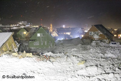
Soon it will be two years ago that the avalanche came down from the mountain Sukkertoppen that destroyed eleven houses and took two lives. There will be a memorial ceremony in Longyearbyen on the day, 19 December.
The avalanche area in Longyearbyen in December 2015. Two people were killed and eleven houses destroyed. One was moved as much as 80 metres. Photo © Svalbardposten.
There has been – and still is – a lot of talking about the avalanche risk in Longyearbyen on all levels. It seems obvious that there have been neglects on various public levels, but it was said officially that there is no institution or individual that may legally be held responsible.
And there is, of course, the question of how to deal with the avalanche risk in future. An official report about the avalanche situation has determined that a large number of houses in Longyearbyen is exposed to various levels of avalanche risk. A local warning system has been established, which has produced mixed results so far; on one occasion, the system produced a false security statement that was spectacularly wrong. Two houses were destroyed on that occasion, and it was a matter of luck that there was no loss of human life. Instruments to measure the thickness of the snow layer have been installed on various slopes close to Longyearbyen. These instruments are supposed to provide real-time data about snow accumulation in locations where people had to measure manually in the past, something that is often difficult or even impossible in situations of severe weather when an increased risk has to be assumed. But that is obviously exactly when you need that kind of data, so these new decives are expect to make a significant improvement to the avalanche warning system.
Avalanche barriers are another measure expected in the future, but they are not there yet, almost two years after the big, tragic 2015 event. Evacuating parts of Longyearbyen, on a situative or permanent basis, is also one of the options which are discussed. The financial aspects of all that is yet another issue.
It does, however, not cost the public much to evacuate certain addresses on a preventive basis. Evacuating parts of Longyearbyen has become a standard procedure during winters since late 2015. Yesterday (14 December), the Sysselmannen has issued an order that certain addresses have to be left until 22 December until further notice. This measure is expected to be in force until the snow is gone, which means, the houses will not be available for months.

These parts of Longyearbyen (marked red) will be evacuated from 22 December until further notice. The complete map is available from the Sysselmannen.
So far, evacuations were made in or before an actual risk situation, based on snow conditions, weather forecasts etc. This time, however, there is no such base for the evacuation, something that becomes clear from the time span of 8 days between the issue of the evacuation order and the date (22 Dec) when it actually enters force. Sysselmannen Kjerstin Askholt says “The ban on traffic is based on the risk evaluation for individuals and public safety, because this area is especially exposed to avalanches. The current practice with a local avalanche warning system and possible evacuations, based on technical advice from avalanche experts, does not exclude a high residual risk and remaining uncertainties, so the houses in question can not be used while there are no measures for avalanche safety in place” (Sysselmannen, auhtor’s translation).
Areas concerned are addresses in way 222 and 226, which are located directly next to the mountain Sukkertoppen, but may be extended to other areas at any time as deemed necessary by authorities.
Evacuating a number of houses for a longer period of time based on general precautionary reasons rather than an actual risk situation appears to be a drastic step, compared to the impact that this has on the lives of those who have to leave their homes for months. There are those who have, next to their home in the area concerned, rented a place elsewhere in Longyearbyen on a permanent basis, something that obviously involves high costs and this is not a contribution to the already difficult housing market in Longyearbyen either. Those who own a place in the area that is affected, are also faced with a substantially difficult situation.
Not a glorious chapter for politics, considering the current development started with the avalance in December 2015 – two years ago.
Source: Sysselmannen
News-Listing live generated at 2025/June/15 at 04:41:52 Uhr (GMT+1)


