-
current
recommendations- Liefdefjord
New page dedicated to one of Spitsbergen's most beautiful fjords. Background information and many photos.
- New Spitsbergen guidebook
The new edition of my Spitsbergen guidebook is out and available now!
- Liefdefjord
New page dedicated to one of Spitsbergen's most beautiful fjords. Background information and many photos.
Page Structure
-
Spitsbergen-News
- Select Month
- April 2025
- March 2025
- February 2025
- January 2025
- December 2024
- November 2024
- October 2024
- September 2024
- August 2024
- July 2024
- June 2024
- May 2024
- April 2024
- March 2024
- February 2024
- January 2024
- December 2023
- November 2023
- October 2023
- September 2023
- August 2023
- July 2023
- June 2023
- May 2023
- April 2023
- March 2023
- February 2023
- January 2023
- December 2022
- November 2022
- October 2022
- September 2022
- August 2022
- July 2022
- June 2022
- May 2022
- April 2022
- March 2022
- February 2022
- January 2022
- December 2021
- November 2021
- October 2021
- September 2021
- August 2021
- July 2021
- June 2021
- May 2021
- April 2021
- March 2021
- February 2021
- January 2021
- December 2020
- November 2020
- October 2020
- September 2020
- August 2020
- July 2020
- June 2020
- May 2020
- April 2020
- March 2020
- February 2020
- January 2020
- December 2019
- November 2019
- October 2019
- September 2019
- August 2019
- July 2019
- June 2019
- May 2019
- April 2019
- March 2019
- February 2019
- January 2019
- December 2018
- November 2018
- October 2018
- September 2018
- August 2018
- July 2018
- June 2018
- May 2018
- April 2018
- March 2018
- February 2018
- January 2018
- December 2017
- November 2017
- October 2017
- September 2017
- August 2017
- July 2017
- June 2017
- May 2017
- April 2017
- March 2017
- February 2017
- January 2017
- December 2016
- November 2016
- October 2016
- September 2016
- August 2016
- July 2016
- June 2016
- May 2016
- April 2016
- March 2016
- February 2016
- January 2016
- December 2015
- November 2015
- October 2015
- September 2015
- August 2015
- July 2015
- June 2015
- May 2015
- April 2015
- March 2015
- February 2015
- January 2015
- December 2014
- November 2014
- October 2014
- September 2014
- August 2014
- July 2014
- June 2014
- May 2014
- April 2014
- March 2014
- February 2014
- January 2014
- December 2013
- November 2013
- October 2013
- September 2013
- August 2013
- July 2013
- June 2013
- May 2013
- April 2013
- March 2013
- February 2013
- January 2013
- December 2012
- November 2012
- October 2012
- September 2012
- August 2012
- July 2012
- June 2012
- May 2012
- April 2012
- March 2012
- February 2012
- January 2012
- December 2011
- November 2011
- October 2011
- September 2011
- August 2011
- May 2011
- April 2011
- March 2011
- February 2011
- January 2011
- December 2010
- November 2010
- September 2010
- August 2010
- July 2010
- June 2010
- May 2010
- April 2010
- March 2010
- February 2010
- November 2009
- October 2009
- August 2009
- July 2009
- June 2009
- May 2009
- April 2009
- March 2009
- February 2009
- January 2009
- December 2008
- November 2008
- October 2008
- August 2008
- July 2008
- June 2008
- May 2008
- April 2008
- March 2008
- February 2008
- April 2000
- Select Month
-
weather information
-
Newsletter

| Guidebook: Spitsbergen-Svalbard |
Isfjord
Spitsbergen's largest fjord: an overview
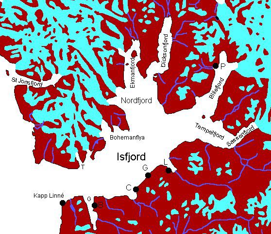
Clockwise: T = Trygghamna, P = Pyramiden, L = Longyearbyen, G = Grumantbyen, C = Colesbukta, G = Grønfjord, B = Barentsburg.
This page is just for a first overview. There are more pages about various places in Isfjord which you can access by clicking on the map above or on the following links:
- Kapp Linné
- Grønfjord, Colesdalen, Grumantbyen
- Adventfjord, Longyearbyen
- Sassenfjord
- Tempelfjord
- Dickson Land, Billefjord
- Trygghamna, Alkhornet
- Ymerbukta & Erdmannflya
- Borebukta & Erdmannflya (north)
- Bohemanflya
- Yoldiabukta
For more, detailed information: the Guidebook Spitsbergen-Svalbard
General
Isfjord is Spitsbergen’s largest fjord. It is cutting more than 100 km into the island with a lot of different branches. The landscape and history are varied, and most settlements of Spitsbergen are here. The climate is favourable, at least for Svalbard standards, as the gulf stream keeps the fjord largely ice-free and temperatures mild. The effect of increasing continentality is noticeable deeper in the fjord, with colder winters and warmer summers. Whereas the Isfjord was often completely frozen during the late winter in the early 20th century, this happens today only in exceptionally cold years, but the smaller side fjords on the north side and in innermost Isfjord (Billefjord, Tempelfjord) still freeze in most winters, although not as reliably as in the 20th century.
Most human activities in Svalbard are concentrated in Isfjord, which puts some pressure on the environment. This includes mining, the settlements in general and a growing tourism industry with a lot of snow mobile traffic in the late winter (late February-early May).
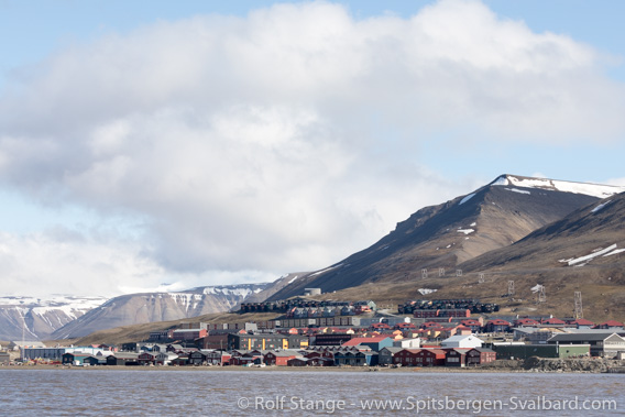
Most of Spitsbergen’s settlements, such as Longyearbyen, are in the Isfjord area.
Protected areas
There are several protected areas in Isfjord, including bird sanctuaries, which may not be entered at all during the breeding season (15 May-15 August). Make sure you know where you may go and where not – boundaries are not marked in the field, there are no signs etc.
Large parts of Isfjord are national parks: The north side all the way from the entrance to Dicksonfjord, then there is another national park that includes Bünsow Land east of Billefjord, Sassenfjord, Tempelfjord and Sassendalen. Tourists may, however, move freely within these national parks, in contrast to most national parks and nature reserves elsewhere.
Geology
Varied. In this large area, almost the whole geology of Svalbard is represented from the basement over Devonian Old Red to Permocarboniferous carbonates and evaporites (anhydrite and gypsym) to the Mesozoic-Tertiary clastic sediment cover. Because of the steep dip of the strata, you can find quite complete successions near the west coast within a small area, for example the Festningen section. In the west, the rocks have been strongly deformed during the Alpidic orogeny in the lower Tertiary, whereas the strata are mostly horizontal in central and eastern parts, at least on the south side of Isfjord. For further information, see individual areas (click on the map).
Recommended book for further, well-digestable (really!) info about geology and landscape of Svalbard.
Landscape
Very varied due to differences in geology and climate. There are wide coastal plains at the west coast, behind which there is a glaciated, alpine mountaineous scenery on the northern side of Isfjord. On the south side, the occurrence of pointed mountains is more or less limited to two N-S stretching mountain chains west of the Grønfjord. East of Grønfjord, the scenery is dominatey by the characteristical plateau-shaped mountains, which are topped by wide plateaus in 400-600 metres altitude. Only few mountains rise over this plateau level, showing what kind of rocks once covered the whole are with a thickness of many hundred metres or probably kilometres, but have fallen victim to erosion. Central and eastern parts of Nordenskiöld Land (that is the area between Isfjord and Bellsund from the west coast almost to the east coast) feature large ice-free valleys with very rich tunda areas, more than anywhere else in Svalbard. Thus, the area offers good hiking opportunities also for longer trekkings, but crossing rivers can be very difficult and even dangerous or impossible.
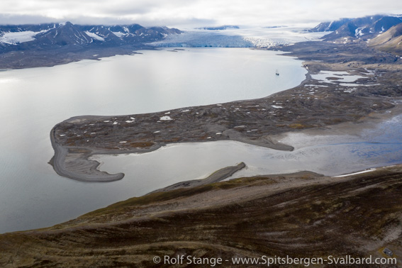
Some typical landscape elements in Isfjord (here seen in Ymerbukta):
flat tundra (foreground), moraine (centre), glacier and mountains.
Nordenskiöld Land between Isfjord and Bellsund is amongst the least glaciated areas of Svalbard, whereas there is a number of calving fronts and a strongly glaciated ‘hinterland’ on the northern side of the Isfjord.
Glacier in Isfjord (Sveabreen).
Flora and fauna
The flora is rich – at least for Svalbard standards – in many places, there are large tundra areas especially on the coastal plains and in the large, ice-free valleys. For example, Colesdalen and Reindalen belong to the biologically most productive areas of Svalbard, with high biodiversity, a dense cover of thick vegetation and accordingly a strong reindeer population, foxes, ptarmigans etc.
On steep cliffs near the coast, there is a number of bird colonies with Brünich’s Guillemots, Kittiwakes and, in places, Puffins which are otherwise rather rare in Svalbard. Polar bears may well be seen year-round, and it is not unusual to encounter one also near the settlements, so the safety routines – most importantly, appropriate weapon and experience – have to be observed everywhere in Isfjord as soon as you set a foot out of any settlement.
History
Long and varied. There are many remains of Pomor hunting stations, who may have been here before Spitsbergen was discovered by Willem Barentsz in 1596. The name ‘Ice Sound’ was given in 1610 by the English whaler Jonas Poole ‘because it was covered with Ice’ (makes sense, doesn’t it?).
During the 19th and 20th century, a number of scientific expeditions have visited the Isfjord that makes it impossible to mention all of them here. Norwegian trappers have had their hunting ground here, a tradition that has partly survived until today. Legendary hunters such as Hilmar Nøis and Arthur Oxaas lived in Isfjord for many years in the first half of the 20th century. Mining started in the late 19th century, but most of the many little mines didn’t survive the stage of exploration and trial mining. All of today’s settlements in the Isfjord were founded as coal mining settlements, Barentsburg and Longyearbyen are the ones which are still in use.
Isfjord gallery
Just a very few pictures for a first taste. As mentioned above, there are more pages (click on the map or on the links at the top of this page) about various places within Isfjord.
- gallery anchor link: #gallery_1854
Click on thumbnail to open an enlarged version of the specific photo.
BOOKS, CALENDAR, POSTCARDS AND MORE
This and other publishing products of the Spitsbergen publishing house in the Spitsbergen-Shop.
last modification: 2025-02-12 ·
copyright: Rolf Stange

