


-
current
recommendations- Liefdefjord
New page dedicated to one of Spitsbergen's most beautiful fjords. Background information and many photos.

- New Spitsbergen guidebook
The new edition of my Spitsbergen guidebook is out and available now!
- Liefdefjord
New page dedicated to one of Spitsbergen's most beautiful fjords. Background information and many photos.
-
weather information

| Guidebook: Spitsbergen-Svalbard |
Home
→ Spitsbergen information
→ Islands: Spitsbergen & Co.
→ Heleysund – Edgeøya – Barentsøya – Tusenøyane
→ Ryke Yseøyane
Ryke Yseøyane
Natural and human history of some small islands in east Svalbard
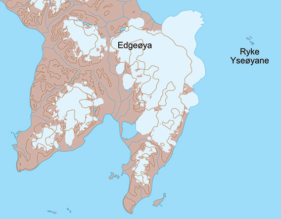
Map showing the position of Ryke Yseøyane east of Edgeøya.
General
Ryke Yseøyane are a group of three small island which, in a wider sense, belongs to Tusenøyane, at least geologically and landscape-wise. Geographically, they are further to the northeast and strictly speaking not considered to be part of Tusenøyane. They were historically rarely visited because of the difficult ice conditions and that is, to some degree, still the case today. And because, well, they are only a few of very small, very remote islands – but this is also what makes them attractive, in a way, at least if you ask me. The land area is only a few km2. Ryke Yseøyane were probably namend after a Dutch whaling Captain of the 17 century and are now part of the Southeast Svalbard Nature Reserve.
The largest island, the one with the hut (see below) is known as Heimøya (“home island”). The northwestern one is Steinøya, the northwestern one is Steinøya (“rock island” or “rocky island”) and the smallest one, the one in the northeast, Ytterøya (“outer island”).
Heimøya, the largest island of Ryke Yseøyane.
There is a separate page on this website (click here) with a virtual tour of Ryke Yseøyane, giving good impressions of the general scenery and telling the story of the dramatic winterings in 1967-69 in some more detail.
For more, detailed information: the Guidebook Spitsbergen-Svalbard

Geology
The geology is virtually the same as in Tusenøyane. Ryke Yseøyane consist entirely of dolerite/diabas (an intrusive rock similar to basalt), which intruded during the upper Jurassic and Cretaceous.
Columnar Diabas (“Basalt”) on Heimøya.
The surrounding rocks, into which they intruded, have been removed by erosion since then. This is the same story as with the islands in Hinlopen Strait or many other places in Edge- and Barentsøya and elsewhere. Other types of rock on Ryke Yseøyane only occur as erratic boulders (glacier deposits from ice age glaciers).
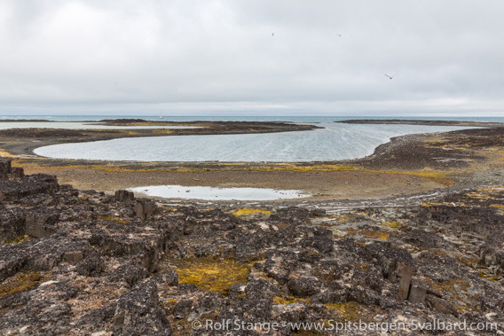
Landscape
Small, rocky, low-lying islands without glaciers or permanent snow-fields. There are a few small tundra lakes. Rocks and small cliffs make landings with small boats a bit tricky.
The highest elevation (24 m) is on Steinøya, which altogether appears a bit steeper, with cliffs around large parts of the coastline.
Flora and fauna
High arctic. Partly rocky and barren, whereas there is a surprisingly rich moss tundra in places. The mosses are very vulnerable – try to stay outside or to step on rocks as much as possible! There are several small sweetwater ponds, which are good breeding habitats for Red-throated divers. These are easily disturbed at their nests, please keep a good distance. Other than that, there can be geese, Common Eider ducks, Grey phalaropes etc.
Black guillemots and glaucous gulls are breeding on some of the steep cliffs.
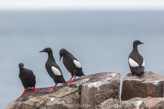
Black guillemots on Steinøya.
History
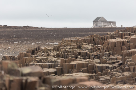
Rarely visited. Older history (whalers, Pomors, trappers, others?) is unknown. It is said that faint remains of an old hut were found near the present one.
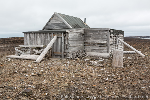
Trapper station from 1967 on Heimøya.
In 1967-69, two Norwegian trappers/adventurers wintered here during two subsequent winters. The second winter was not planned, but the ship which should pick them up, could not get through the ice. One of them, Steinar Ingebrigtsen, disappeared during the second winter. The story is that he walked out onto the ice from Steinøya and got into loose drift ice, a deadly trap.
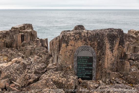
Memorial stone for Steinar Ingebrigtsen on Steinøya.
Click here for a virtual tour of Ryke Yseøyane including more details of the 1967-69 wintering.
Photo galleries Ryke Yseøyane
All images are from a visit in August 2015. I have decided to include a relatively large number because there are so few pictures of these islands available.
Photo galleries Ryke Yseøyane: Heimøya
The first galleries has photos of Heimøya, the largest of the three islands.
Ryke Yseøyane: Heimøya (gallery)
- gallery anchor link: #gallery_2160
Click on thumbnail to open an enlarged version of the specific photo.


Photo galleries Ryke Yseøyane: Steinøya
The photos of the second selection were taken on Steinøya, the northwestern island from which Steinar Ingebrigtsen went out onto the ice and disappeared in 1969. The memorial stone is on the cliff from which is he is said to have gone down (over a snow slope that is there during wintertime) and into the ice.
Ryke Yseøyane: Steinøya (gallery)
- gallery anchor link: #gallery_2163
Click on thumbnail to open an enlarged version of the specific photo.


BOOKS, CALENDAR, POSTCARDS AND MORE
This and other publishing products of the Spitsbergen publishing house in the Spitsbergen-Shop.
-

Norwegens arktischer Norden (1): Spitzbergen
Photobook: Norway's arctic islands. The text in this book is German. [shop url="https://shop.spitzbergen.de/en/polar-books/70-norwegens-arktischer-norden-1-aerial-arctic-9783937903262.html"] ← BackOrder now -
Norwegens arktischer Norden (2): Aerial Arctic
Lofoten, Jan Mayen and Spitsbergen from the air - Photobook: Norway's arctic islands. The text in this book is German, but there is very little text, so I am sure that you will enjoy it regardless which languages you read (or not).Order now -
Poster “Svalbardhytter”
The poster "Svalbardhytter" (70 x 100 cm) visualizes the diversity of Spitsbergen's huts in a range of arctic landscapes.Order now -
Book “Svalbardhytter”
The companion book for the Svalbardhytter poster. The poster visualises the diversity of Spitsbergen‘s huts and their stories in a range of Arctic landscapes. The book tells the stories of the huts in three languages.Order now -
Spitsbergen – Svalbard. The complete guidebook
Comprehensive guidebook about Spitsbergen. Background (wildlife, plants, geology, history etc.), practical information including travelling seasons, how to travel, description of settlements, routes and regions.Order now -
Rocks and Ice. Landscapes of the North
A geographical traveling accompaniment to Spitsbergen and East Greenland (68-74°N). This is the English edition of the German book "Steine und Eis".Order now -
East Greenland in Winter
Join an exciting journey with dog, skis and tent through the wintery wastes of East Greenland! We were five guys and a dog when we started in Ittoqqortoormiit, the northernmost one of two settlements on Greenland’s east coast.Order now -
Postcard set Spitsbergen (Svalbard)
12 Spitsbergen postcards in a beautifully designed tray. Individually numbered limited edition!Order now -
Limited edition postcard set Antarctica
12 postcards which come in a beautifully designed tray. Beautiful images from South Georgia across Antarctica from the Antarctic Peninsula to the Ross Sea and up to Macquarie Island and Campbell Island.Order now
last modification: 2024-06-17 ·
copyright: Rolf Stange


-
Books, Calendar, Postcards and more

-


