-
current
recommendations- Liefdefjord
New page dedicated to one of Spitsbergen's most beautiful fjords. Background information and many photos.
- New Spitsbergen guidebook
The new edition of my Spitsbergen guidebook is out and available now!
- Liefdefjord
New page dedicated to one of Spitsbergen's most beautiful fjords. Background information and many photos.
Page Structure
-
Spitsbergen-News
- Select Month
- June 2025
- May 2025
- April 2025
- March 2025
- February 2025
- January 2025
- December 2024
- November 2024
- October 2024
- September 2024
- August 2024
- July 2024
- June 2024
- May 2024
- April 2024
- March 2024
- February 2024
- January 2024
- December 2023
- November 2023
- October 2023
- September 2023
- August 2023
- July 2023
- June 2023
- May 2023
- April 2023
- March 2023
- February 2023
- January 2023
- December 2022
- November 2022
- October 2022
- September 2022
- August 2022
- July 2022
- June 2022
- May 2022
- April 2022
- March 2022
- February 2022
- January 2022
- December 2021
- November 2021
- October 2021
- September 2021
- August 2021
- July 2021
- June 2021
- May 2021
- April 2021
- March 2021
- February 2021
- January 2021
- December 2020
- November 2020
- October 2020
- September 2020
- August 2020
- July 2020
- June 2020
- May 2020
- April 2020
- March 2020
- February 2020
- January 2020
- December 2019
- November 2019
- October 2019
- September 2019
- August 2019
- July 2019
- June 2019
- May 2019
- April 2019
- March 2019
- February 2019
- January 2019
- December 2018
- November 2018
- October 2018
- September 2018
- August 2018
- July 2018
- June 2018
- May 2018
- April 2018
- March 2018
- February 2018
- January 2018
- December 2017
- November 2017
- October 2017
- September 2017
- August 2017
- July 2017
- June 2017
- May 2017
- April 2017
- March 2017
- February 2017
- January 2017
- December 2016
- November 2016
- October 2016
- September 2016
- August 2016
- July 2016
- June 2016
- May 2016
- April 2016
- March 2016
- February 2016
- January 2016
- December 2015
- November 2015
- October 2015
- September 2015
- August 2015
- July 2015
- June 2015
- May 2015
- April 2015
- March 2015
- February 2015
- January 2015
- December 2014
- November 2014
- October 2014
- September 2014
- August 2014
- July 2014
- June 2014
- May 2014
- April 2014
- March 2014
- February 2014
- January 2014
- December 2013
- November 2013
- October 2013
- September 2013
- August 2013
- July 2013
- June 2013
- May 2013
- April 2013
- March 2013
- February 2013
- January 2013
- December 2012
- November 2012
- October 2012
- September 2012
- August 2012
- July 2012
- June 2012
- May 2012
- April 2012
- March 2012
- February 2012
- January 2012
- December 2011
- November 2011
- October 2011
- September 2011
- August 2011
- May 2011
- April 2011
- March 2011
- February 2011
- January 2011
- December 2010
- November 2010
- September 2010
- August 2010
- July 2010
- June 2010
- May 2010
- April 2010
- March 2010
- February 2010
- November 2009
- October 2009
- August 2009
- July 2009
- June 2009
- May 2009
- April 2009
- March 2009
- February 2009
- January 2009
- December 2008
- November 2008
- October 2008
- August 2008
- July 2008
- June 2008
- May 2008
- April 2008
- March 2008
- February 2008
- April 2000
- Select Month
-
weather information
-
Newsletter

| Guidebook: Spitsbergen-Svalbard |
Kiepertøya
Kiepertøya is a small island in southern Hinlopen Strait. It is made up of three peninsulas, which are connected by low-lying land bridges; in some places, the shores on both sides are no more than 100 m away from each other or even less!
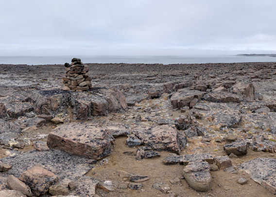
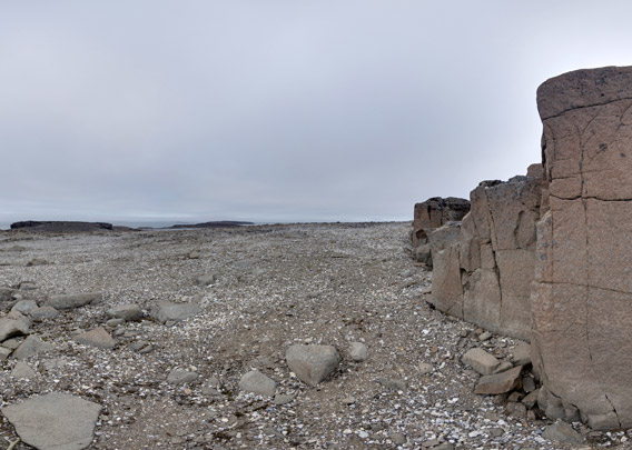
Geologically, Kiepertøya consists of dolerite, a magmatic kind of rock that resembles basalt. Weathering is attacking dolerite only slowly and the result are coarse blocks. As a consequence, the island is very rocky and walking is not exactly easy.
- pano anchor link: #170808d_Kiepertoya_047HDR
All three of the above-mentioned peninsulas have low-lying rocky hills, the greatest heights not exceeding 34 metres. Locally, ther are small, steep rock cliffs. Altogether, Kiepertøya makes a very barren, desolate impression.
- pano anchor link: #170808d_Kiepertoya_065HDR
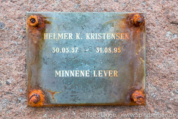
A sad bit of history adds to the gloomy atmosphere. It was on 31 August 1995 that the seaman Helmer Kristensen was killed on Kiepertøya by a polar bear. Kristensen was one of several crew members of a small, ice-strengthened expedition ship carrying passengers who went ashore for a little walk. The group was attacked by a very aggressive polar bear. The only weapon the group had was a little pistol, far from strong enough to stop a furious animal of that size even though several bullets hit the bear’s head. Kristensen was killed and another mean injured. The polar bear was later shot by the Sysselmannen (police).
A group of tourists from the same ship was also ashore on Kiepertøya at the same time. The guides of the tourist group were, in contrast to the crew, adequately armed.
- pano anchor link: #170808d_Kiepertoya_083HDR

Memorial for Helmer Kristensen, who was killed by a polar bear here on Kiepertøya
on 31 August 1995.
BOOKS, CALENDAR, POSTCARDS AND MORE
This and other publishing products of the Spitsbergen publishing house in the Spitsbergen-Shop.
last modification: 2019-03-16 ·
copyright: Rolf Stange


