-
current
recommendations- Liefdefjord
New page dedicated to one of Spitsbergen's most beautiful fjords. Background information and many photos.
- New Spitsbergen guidebook
The new edition of my Spitsbergen guidebook is out and available now!
- Liefdefjord
New page dedicated to one of Spitsbergen's most beautiful fjords. Background information and many photos.
Page Structure
-
Spitsbergen-News
- Select Month
- June 2025
- May 2025
- April 2025
- March 2025
- February 2025
- January 2025
- December 2024
- November 2024
- October 2024
- September 2024
- August 2024
- July 2024
- June 2024
- May 2024
- April 2024
- March 2024
- February 2024
- January 2024
- December 2023
- November 2023
- October 2023
- September 2023
- August 2023
- July 2023
- June 2023
- May 2023
- April 2023
- March 2023
- February 2023
- January 2023
- December 2022
- November 2022
- October 2022
- September 2022
- August 2022
- July 2022
- June 2022
- May 2022
- April 2022
- March 2022
- February 2022
- January 2022
- December 2021
- November 2021
- October 2021
- September 2021
- August 2021
- July 2021
- June 2021
- May 2021
- April 2021
- March 2021
- February 2021
- January 2021
- December 2020
- November 2020
- October 2020
- September 2020
- August 2020
- July 2020
- June 2020
- May 2020
- April 2020
- March 2020
- February 2020
- January 2020
- December 2019
- November 2019
- October 2019
- September 2019
- August 2019
- July 2019
- June 2019
- May 2019
- April 2019
- March 2019
- February 2019
- January 2019
- December 2018
- November 2018
- October 2018
- September 2018
- August 2018
- July 2018
- June 2018
- May 2018
- April 2018
- March 2018
- February 2018
- January 2018
- December 2017
- November 2017
- October 2017
- September 2017
- August 2017
- July 2017
- June 2017
- May 2017
- April 2017
- March 2017
- February 2017
- January 2017
- December 2016
- November 2016
- October 2016
- September 2016
- August 2016
- July 2016
- June 2016
- May 2016
- April 2016
- March 2016
- February 2016
- January 2016
- December 2015
- November 2015
- October 2015
- September 2015
- August 2015
- July 2015
- June 2015
- May 2015
- April 2015
- March 2015
- February 2015
- January 2015
- December 2014
- November 2014
- October 2014
- September 2014
- August 2014
- July 2014
- June 2014
- May 2014
- April 2014
- March 2014
- February 2014
- January 2014
- December 2013
- November 2013
- October 2013
- September 2013
- August 2013
- July 2013
- June 2013
- May 2013
- April 2013
- March 2013
- February 2013
- January 2013
- December 2012
- November 2012
- October 2012
- September 2012
- August 2012
- July 2012
- June 2012
- May 2012
- April 2012
- March 2012
- February 2012
- January 2012
- December 2011
- November 2011
- October 2011
- September 2011
- August 2011
- May 2011
- April 2011
- March 2011
- February 2011
- January 2011
- December 2010
- November 2010
- September 2010
- August 2010
- July 2010
- June 2010
- May 2010
- April 2010
- March 2010
- February 2010
- November 2009
- October 2009
- August 2009
- July 2009
- June 2009
- May 2009
- April 2009
- March 2009
- February 2009
- January 2009
- December 2008
- November 2008
- October 2008
- August 2008
- July 2008
- June 2008
- May 2008
- April 2008
- March 2008
- February 2008
- April 2000
- Select Month
-
weather information
-
Newsletter

| Guidebook: Spitsbergen-Svalbard |
Svalbard today
History of Spitsbergen
On this page you will find a little overview of Spitsbergen’s settlements and stations.
Longyearbyen
During the 1970s and 80s, the focus of economical activity has slowly moved away from mining. Longyearbyen is the centre of Norwegian administration. It is the residence of the Sysselmannen (‘Gouvernour’ with police- and to some degree juridical responsibility). Today, Longyearbyen is a centre for modern service industries. Tourism takes an important and still-growing role.

Modern residential buildings for families in central location in Longyearbyen.
There are three museums (Svalbardmuseum, North Pole Expedition Museum, Mine Museum in Gruve 3), university, public library, school with swimming- and sports hall, kindergarten as well as supermarket, several shops, galleries and a range of hotels, restaurants and a large and still growing number of tour operators. Tourism, science and administration are now the most important economical activities. Coal mining is slowly disappearing from the scene. There is still coal mining going on in mine 7 close to Longyearbyen, but the large mines in Sveagruva, Svea Nord and Lunckefjellet, are closed.
Longyearbyen has a population of more than 2,000 today, which is internationally mixed. Norwegians are the biggest group, followed by other Scandinavian nationalities, but there are also a lot of Thai people, various European nationalities, Russian, US-Americans and others. Longyearbyen has become a modern and popular place to live. The downside of this development is that the housing market has become very difficult and prices for accommodation are amongst the highest in all of Norway, which in itself is not exactly a cheap country either.

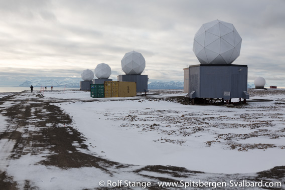
Because of its position near the pole, Spitsbergen is a good place for antennas to pick up data from certain satellites.
Due to its position near the pole, Spitsbergen is a good place for antennas to receive data from certain satellites. For the amount of data, a fibre glass cable has been laid from Longyearbyen to the mainland of Norway, which can provide super-fast internet connection – maybe an opportunity for ‘new economy’ in the low-tax area Svalbard? SvalSat is a main provider of satellite communication services with huge volumes of data uploads and downloads from an antenna park on top of Platåberg above the airport, and an important factor in Longyearbyen’s economy today.
There are several more settlements and stations in Spitsbergen. Here is a short overview. Please refer to the pages in the panorama section (click the name of the place in each section) for some more information and impressions from the various places.
Ny-Ålesund
The mines in Ny-Ålesund were closed in 1962 after several accidents. Later, the place was re-designed to house an international research village. There is not really a permanent population, but 30-40 semi-permanent staff and 100-150 visiting scientists during the season.
The Russian settlements in Spitsbergen: Barentsburg and Pyramiden
Besides the Norwegians, only the Russians still do coal mining. The state-owned Trust Arktikugol has closed Pyramiden in the Billefjord in 1998, but they are still mining in Barentsburg.
Stations: Hornsund, Isfjord Radio/Kapp Linné, Bjørnøya, Hopen
Outside Ny-Ålesund, Poland is the only country next to Norway to run a permanently staffed research station, which is located in Hornsund.

The Polish research station in Isbjørnhamna, Hornsund.
There are several stations. The former radio station Isfjord Radio at Kapp Linné in Isfjord, just on the west coast, is run automatically since 1999 and not in use anymore since a glass fibre cable made it technically obsolete. It is run as a wilderness hotel today.

The former station Isfjord Radio at Kapp Linné.
There are still permanently staffed weather stations on Hopen, Bjørnøya as well as Jan Mayen (does not belong to Svalbard).
Trappers
Today, Trappers are a rare side issue. There are very few how have chosen this as their main profession and long-term lifestyle. There is one Norwegian who has lived on his own on the northern side of Isfjord for more than 40 years now. Another one lives in the Bellsund area. The trapping station Farmhamna on the west coast north of Isfjord is also still in use, but not permanently. The trapping station at Austfjordneset in Wijdefjord is owned by the Sysselmannen who usually gives it to individuals who seek a year of solitude, being active and professional hunters for at least years, but it is closed at the time of writing (early 2019).
There is another active trapper station in Farmhamna on the west coast of Spitsbergen, just north of Isfjord, but it is not permanently occupied.
All of Spitsbergen’s trappers have chosen their lifestyle and their respective places to live amongst others because of the calm neighbourhood. Respect their privacy.
BOOKS, CALENDAR, POSTCARDS AND MORE
This and other publishing products of the Spitsbergen publishing house in the Spitsbergen-Shop.
last modification: 2019-03-05 ·
copyright: Rolf Stange


