


-
current
recommendations- Liefdefjord
New page dedicated to one of Spitsbergen's most beautiful fjords. Background information and many photos.

- New Spitsbergen guidebook
The new edition of my Spitsbergen guidebook is out and available now!
- Liefdefjord
New page dedicated to one of Spitsbergen's most beautiful fjords. Background information and many photos.
-
weather information

| Guidebook: Spitsbergen-Svalbard |
Liefdefjord: Andøyane
360° panorama images and general background
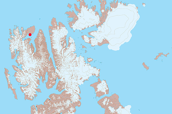
The small island group of Andøyane is located in Liefdefjord.
Andøyane (“The duck islands”) are a group of small islands in outer Liefdefjord, south of Reinsdyrflya. They are low-lying, mostly almost flat, and seen from a distance, they don’t appear to be spectacular. But if you get close, then the mixture of little beaches, curved shorelines, red rocks, flowers and lichens and many other little scenic details unfold a charme that is hard to escape.
Andøyane Panorama 1: Sørøstre Andøya
- pano anchor link: #180715c_Andoyane_21HDR
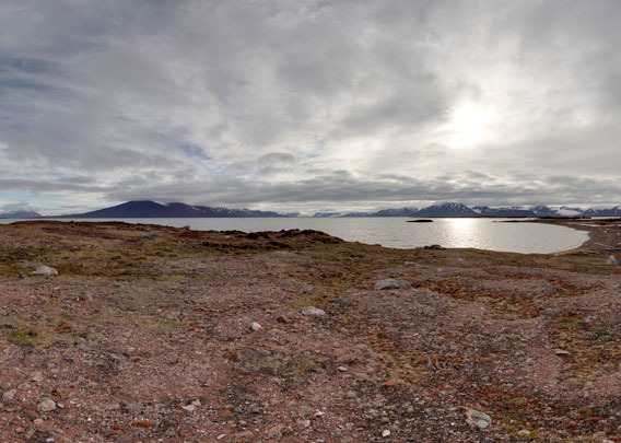
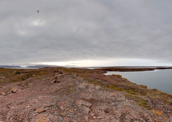
The largest island, Store Andøya, is a good two kilometres in diametre, the second largest one – Vesle Andøya – less than half that size and the remaining ones are even smaller. This first panorama is from the southeastern island. It does not have an individual name, let’s just call her Sørøstre Andøya (“southeastern duck island”) here. It is a good 700 metres long, but wherever you are, you are never more than a good 50 metres away from the shore.
Andøyane Panorama 2: Søre Andøya
- pano anchor link: #180805c_Andoyane_148HDR
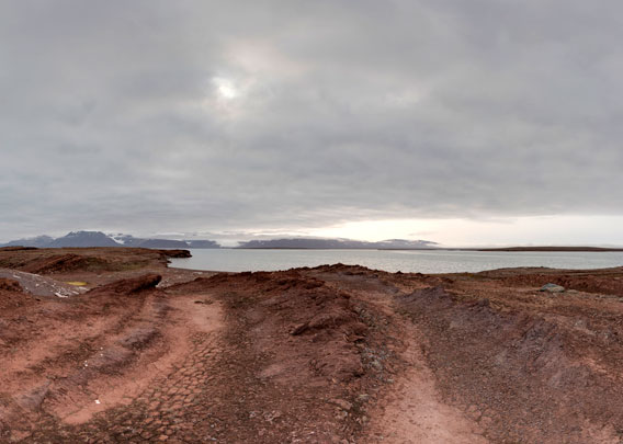
Also this island, “Søre (southern) Andøya”, does not have a name on the map, and it is hardly more than 600 across. Nevertheless, a little walk across the island can be very rewarding. As the name of the islands suggests, there are a lot of birds breeding here: next to the common eider ducks which breed here in large numbers, there are plenty of arctic terns, grey phalaropes and purple sandpipers, and if you look carefully, chances to see a king eider are quite good, to mention just a few common species for this area.
Andøyane Panorama 3: Søre Andøya
- pano anchor link: #180805c_Andoyane_167HDR
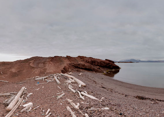
So there is good reason to give these islands legal protection beyond the general rules of the Svalbardmiljølov (Svalbard environmental law): since 2020, they are a bird reserve, which means that it is not allowed to approach them to less than 300 metres during the breeding period, legally defined as the time from 15 May to 15 August.
This does unfortunately not protect the islands from the plastic litter which the currents bring. It is mostly what is thrown overboard from fishing vessels. And we collect it on the beaches as much as we can. We – that’s both me personally with colleagues and passengers and others in the arctic tourism industry – have already done a number of beach clean-ups on Andøyane, but I am afraid many more will be needed until the problem is solved, if this ever happens 🙁 and from 2025, this will not happen anymore, because new regulations will then now allow tourist visits anymore. And nobody else has the capacity to do beach cleaning at scale.
Andøyane Panorama 3: Søre Andøya
- pano anchor link: #180805c_Andoyane_186HDR
Landscape-wise, Andøyane are very similar to Reinsdyrflya, the large plain to the north of Liefdefjord. There are some huge erratic boulders, small lakes and wetland areas and series of old beach ridges and other geological evidence for the post-glacial land uplift. The sandstone belongs to the Devonian Old Red sandstone and has hematite, hence the beautiful reddish colour.
Photo gallery Andøyane
And finally, as usual on these pages, a collection of images from Andøyane, trying to transport some of their inherent beauty.
- gallery anchor link: #gallery_3079
Click on thumbnail to open an enlarged version of the specific photo.


BOOKS, CALENDAR, POSTCARDS AND MORE
This and other publishing products of the Spitsbergen publishing house in the Spitsbergen-Shop.
-

Norwegens arktischer Norden (1): Spitzbergen
Photobook: Norway's arctic islands. The text in this book is German. [shop url="https://shop.spitzbergen.de/en/polar-books/70-norwegens-arktischer-norden-1-aerial-arctic-9783937903262.html"] ← BackOrder now -
Norwegens arktischer Norden (2): Aerial Arctic
Lofoten, Jan Mayen and Spitsbergen from the air - Photobook: Norway's arctic islands. The text in this book is German, but there is very little text, so I am sure that you will enjoy it regardless which languages you read (or not).Order now -
Poster “Svalbardhytter”
The poster "Svalbardhytter" (70 x 100 cm) visualizes the diversity of Spitsbergen's huts in a range of arctic landscapes.Order now -
Book “Svalbardhytter”
The companion book for the Svalbardhytter poster. The poster visualises the diversity of Spitsbergen‘s huts and their stories in a range of Arctic landscapes. The book tells the stories of the huts in three languages.Order now -
Spitsbergen – Svalbard. The complete guidebook
Comprehensive guidebook about Spitsbergen. Background (wildlife, plants, geology, history etc.), practical information including travelling seasons, how to travel, description of settlements, routes and regions.Order now -
Rocks and Ice. Landscapes of the North
A geographical traveling accompaniment to Spitsbergen and East Greenland (68-74°N). This is the English edition of the German book "Steine und Eis".Order now -
East Greenland in Winter
Join an exciting journey with dog, skis and tent through the wintery wastes of East Greenland! We were five guys and a dog when we started in Ittoqqortoormiit, the northernmost one of two settlements on Greenland’s east coast.Order now -
Postcard set Spitsbergen (Svalbard)
12 Spitsbergen postcards in a beautifully designed tray. Individually numbered limited edition!Order now -
Limited edition postcard set Antarctica
12 postcards which come in a beautifully designed tray. Beautiful images from South Georgia across Antarctica from the Antarctic Peninsula to the Ross Sea and up to Macquarie Island and Campbell Island.Order now
last modification: 2024-06-25 ·
copyright: Rolf Stange


-
Books, Calendar, Postcards and more

-


