


-
current
recommendations- Liefdefjord
New page dedicated to one of Spitsbergen's most beautiful fjords. Background information and many photos.

- New Spitsbergen guidebook
The new edition of my Spitsbergen guidebook is out and available now!
- Liefdefjord
New page dedicated to one of Spitsbergen's most beautiful fjords. Background information and many photos.
-
weather information

| Guidebook: Spitsbergen-Svalbard |
Bjørnøya (Bear Island): Kvalrossbukta
Early 20th century industrial whaling on Bjørnøya
Kvalrossbukta 1
- pano anchor link: #Kvalrossbukta_29Mai14_030HDR
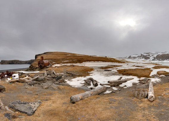
Located on the southeastern side of Bear Island, Kvalrossbukta is one of few bays on the island that offer easy access to flat ground on shore. Even though the bay is not exactly perfectly well sheltered and it has some shallows, altogether it was the best place available to establish a whaling station.
Kvalrossbukta 2
- pano anchor link: #Kvalrossbukta_29Mai14_010HDR

The whaling station in Kvalrossbukta was in use from 1905 to 1908, in the second phase of arctic whaling. The early whalers, in the 17th century, had used rowing boats and hand-thrown harpoons. In the early 20th century, the industrial age, the whalers had steam power and harpoon guns with explosive harpoon heads at their disposal. This meant that all whale species, including the largest and fastest ones, were on their target list. Species like the Blue whale, Finn whale and Humpback whale were driven near extinction in the north Atlantic within a few years. Then, the whaling moved south, towards antarctic waters.
BOOKS, CALENDAR, POSTCARDS AND MORE
This and other publishing products of the Spitsbergen publishing house in the Spitsbergen-Shop.
-

Norwegens arktischer Norden (1): Spitzbergen
Photobook: Norway's arctic islands. The text in this book is German. [shop url="https://shop.spitzbergen.de/en/polar-books/70-norwegens-arktischer-norden-1-aerial-arctic-9783937903262.html"] ← BackOrder now -
Norwegens arktischer Norden (2): Aerial Arctic
Lofoten, Jan Mayen and Spitsbergen from the air - Photobook: Norway's arctic islands. The text in this book is German, but there is very little text, so I am sure that you will enjoy it regardless which languages you read (or not).Order now -
Poster “Svalbardhytter”
The poster "Svalbardhytter" (70 x 100 cm) visualizes the diversity of Spitsbergen's huts in a range of arctic landscapes.Order now -
Book “Svalbardhytter”
The companion book for the Svalbardhytter poster. The poster visualises the diversity of Spitsbergen‘s huts and their stories in a range of Arctic landscapes. The book tells the stories of the huts in three languages.Order now -
Spitsbergen – Svalbard. The complete guidebook
Comprehensive guidebook about Spitsbergen. Background (wildlife, plants, geology, history etc.), practical information including travelling seasons, how to travel, description of settlements, routes and regions.Order now -
Rocks and Ice. Landscapes of the North
A geographical traveling accompaniment to Spitsbergen and East Greenland (68-74°N). This is the English edition of the German book "Steine und Eis".Order now -
East Greenland in Winter
Join an exciting journey with dog, skis and tent through the wintery wastes of East Greenland! We were five guys and a dog when we started in Ittoqqortoormiit, the northernmost one of two settlements on Greenland’s east coast.Order now -
Postcard set Spitsbergen (Svalbard)
12 Spitsbergen postcards in a beautifully designed tray. Individually numbered limited edition!Order now -
Limited edition postcard set Antarctica
12 postcards which come in a beautifully designed tray. Beautiful images from South Georgia across Antarctica from the Antarctic Peninsula to the Ross Sea and up to Macquarie Island and Campbell Island.Order now
last modification: 2025-01-26 ·
copyright: Rolf Stange


-
Books, Calendar, Postcards and more

-


