


-
current
recommendations- Liefdefjord
New page dedicated to one of Spitsbergen's most beautiful fjords. Background information and many photos.

- New Spitsbergen guidebook
The new edition of my Spitsbergen guidebook is out and available now!
- Liefdefjord
New page dedicated to one of Spitsbergen's most beautiful fjords. Background information and many photos.
-
weather information

| Guidebook: Spitsbergen-Svalbard |
East coast of Spitsbergen: Crollbreen
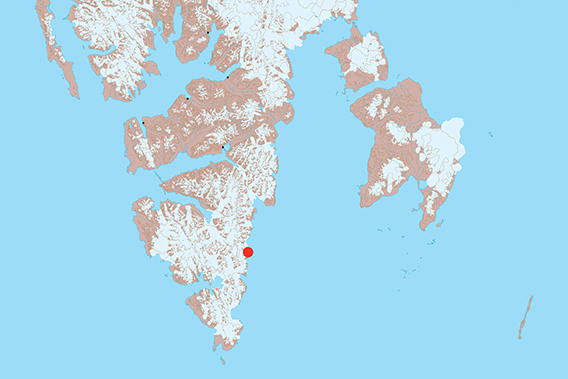
Crollbreen is located on the southern east coast of Spitsbergen.
Crollbreen is a “small”, rather unknown glacier on the southern east coast of Spitsbergen. A remote coast which is hardly ever visited by people. The coastal waters are completely uncharted and there are definitely some shallows, so access from the sea is not easy. This is, if at all, then something for small, robust boats with experienced skippers on fine weather days where you can make a slow, careful approach.
- pano anchor link: #180814c_Crollbreen_465HDR
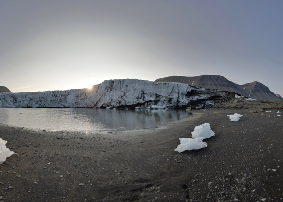
This is what we did in 2018, and it was exciting to have a closer look. Crollbreen was shown with a glacier front at the sea on all maps, but it has retreated strongly in recent years, so it is not terminating at the sea anymore, but in a lagoon.
- pano anchor link: #180814c_Crollbreen_446HDR
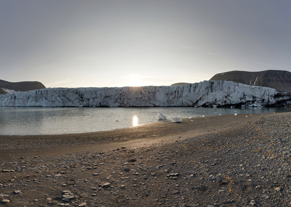
On the north side, the glacier front is resting on land, so there is no steep calving ice cliff anymore.
- pano anchor link: #180814c_Crollbreen_465HDR
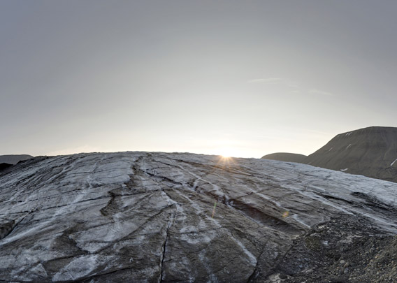
This makes altogether for a young, different landscape, which came into existence only in very recent years due to the retreat of the glacier, witnessing the changing climate. Maybe we were indeed the very first people to walk along the beach of the lagoon? You have to be very careful when you say that you are the first one to have done something in Spitsbergen, but in this case ..? Possible, at least. If you have been there before, please let me know 🙂
BOOKS, CALENDAR, POSTCARDS AND MORE
This and other publishing products of the Spitsbergen publishing house in the Spitsbergen-Shop.
-

Norwegens arktischer Norden (1): Spitzbergen
Photobook: Norway's arctic islands. The text in this book is German. [shop url="https://shop.spitzbergen.de/en/polar-books/70-norwegens-arktischer-norden-1-aerial-arctic-9783937903262.html"] ← BackOrder now -
Norwegens arktischer Norden (2): Aerial Arctic
Lofoten, Jan Mayen and Spitsbergen from the air - Photobook: Norway's arctic islands. The text in this book is German, but there is very little text, so I am sure that you will enjoy it regardless which languages you read (or not).Order now -
Poster “Svalbardhytter”
The poster "Svalbardhytter" (70 x 100 cm) visualizes the diversity of Spitsbergen's huts in a range of arctic landscapes.Order now -
Book “Svalbardhytter”
The companion book for the Svalbardhytter poster. The poster visualises the diversity of Spitsbergen‘s huts and their stories in a range of Arctic landscapes. The book tells the stories of the huts in three languages.Order now -
Spitsbergen – Svalbard. The complete guidebook
Comprehensive guidebook about Spitsbergen. Background (wildlife, plants, geology, history etc.), practical information including travelling seasons, how to travel, description of settlements, routes and regions.Order now -
Rocks and Ice. Landscapes of the North
A geographical traveling accompaniment to Spitsbergen and East Greenland (68-74°N). This is the English edition of the German book "Steine und Eis".Order now -
East Greenland in Winter
Join an exciting journey with dog, skis and tent through the wintery wastes of East Greenland! We were five guys and a dog when we started in Ittoqqortoormiit, the northernmost one of two settlements on Greenland’s east coast.Order now -
Postcard set Spitsbergen (Svalbard)
12 Spitsbergen postcards in a beautifully designed tray. Individually numbered limited edition!Order now -
Limited edition postcard set Antarctica
12 postcards which come in a beautifully designed tray. Beautiful images from South Georgia across Antarctica from the Antarctic Peninsula to the Ross Sea and up to Macquarie Island and Campbell Island.Order now
last modification: 2024-12-12 ·
copyright: Rolf Stange


-
Books, Calendar, Postcards and more

-


