


-
current
recommendations- Liefdefjord
New page dedicated to one of Spitsbergen's most beautiful fjords. Background information and many photos.

- New Spitsbergen guidebook
The new edition of my Spitsbergen guidebook is out and available now!
- Liefdefjord
New page dedicated to one of Spitsbergen's most beautiful fjords. Background information and many photos.
-
weather information

| Guidebook: Spitsbergen-Svalbard |
Sørhamna
360°-Panoramas
Sørhamna 1
- pano anchor link: #Kvalrossbukta_29Mai14_120HDR
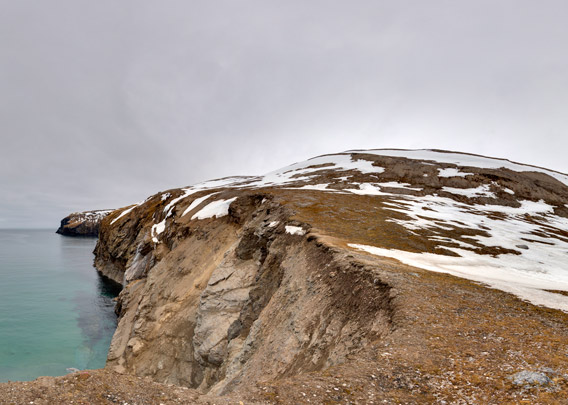
The bay Sørhamna is the only bay on Bear Island that deserves to be called a natural harbour. It offers good anchorage unless wind and sea are coming in from the south. It has a nice beach, but no access to the island from there unless you climb up a rather steep cliff, something that is not impossible there but should not be done for environmental reasons (breeding seabirds on the cliffs, erosion).
It is late May, the time of the snow melt. Wide areas of very wet, heavy snow make walking hard at this time of year.
Sørhamna 2
- pano anchor link: #Kvalrossbukta_29Mai14_145HDR
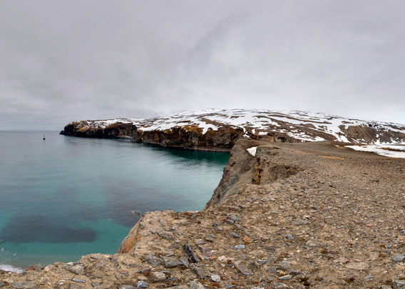
Sørhamna was the site of a remarkable adventure, when the German journalist and polar adventurer Theodor Lerner started to take parts of Bear Island in possession in 1898. He considered both the coal occurrences and the natural harbours to be strategically important and he wanted them to be under control of the German empire of those years. He even managed to drive the Russian battleship Svetlana away! Finally, however, he had to abandon his Bear Island adventures due to lack of financial and political support.
This must approximately have been the site of the hut that was Theodor Lerner’s headquarter in those years on Bear Island.
BOOKS, CALENDAR, POSTCARDS AND MORE
This and other publishing products of the Spitsbergen publishing house in the Spitsbergen-Shop.
-

Norwegens arktischer Norden (1): Spitzbergen
Photobook: Norway's arctic islands. The text in this book is German. [shop url="https://shop.spitzbergen.de/en/polar-books/70-norwegens-arktischer-norden-1-aerial-arctic-9783937903262.html"] ← BackOrder now -
Norwegens arktischer Norden (2): Aerial Arctic
Lofoten, Jan Mayen and Spitsbergen from the air - Photobook: Norway's arctic islands. The text in this book is German, but there is very little text, so I am sure that you will enjoy it regardless which languages you read (or not).Order now -
Poster “Svalbardhytter”
The poster "Svalbardhytter" (70 x 100 cm) visualizes the diversity of Spitsbergen's huts in a range of arctic landscapes.Order now -
Book “Svalbardhytter”
The companion book for the Svalbardhytter poster. The poster visualises the diversity of Spitsbergen‘s huts and their stories in a range of Arctic landscapes. The book tells the stories of the huts in three languages.Order now -
Spitsbergen – Svalbard. The complete guidebook
Comprehensive guidebook about Spitsbergen. Background (wildlife, plants, geology, history etc.), practical information including travelling seasons, how to travel, description of settlements, routes and regions.Order now -
Rocks and Ice. Landscapes of the North
A geographical traveling accompaniment to Spitsbergen and East Greenland (68-74°N). This is the English edition of the German book "Steine und Eis".Order now -
East Greenland in Winter
Join an exciting journey with dog, skis and tent through the wintery wastes of East Greenland! We were five guys and a dog when we started in Ittoqqortoormiit, the northernmost one of two settlements on Greenland’s east coast.Order now -
Postcard set Spitsbergen (Svalbard)
12 Spitsbergen postcards in a beautifully designed tray. Individually numbered limited edition!Order now -
Limited edition postcard set Antarctica
12 postcards which come in a beautifully designed tray. Beautiful images from South Georgia across Antarctica from the Antarctic Peninsula to the Ross Sea and up to Macquarie Island and Campbell Island.Order now
last modification: 2017-12-23 ·
copyright: Rolf Stange


-
Books, Calendar, Postcards and more

-


