


-
current
recommendations- Liefdefjord
New page dedicated to one of Spitsbergen's most beautiful fjords. Background information and many photos.

- New Spitsbergen guidebook
The new edition of my Spitsbergen guidebook is out and available now!
- Liefdefjord
New page dedicated to one of Spitsbergen's most beautiful fjords. Background information and many photos.
-
weather information

| Guidebook: Spitsbergen-Svalbard |
Home
→ * Photos, Panoramas, Videos and Webcams
→ Spitsbergen Panoramas
→ Trygghamna: Knuvlen
Trygghamna: Knuvlen
360°-Panorama and photo gallery

The little mountain Knuvlen is located in inner Trygghamna.
The little mountain Knuvlen is situated between glaciers close to the coast in innermost Trygghamna. „Trygghamna“ means „Safe Harbour“, a name given by English whalers in the 17th century; also known as „Behouden Haven“, the equivalent name used by their Dutch competitors. It was kind of a safe natural harbour for them, close to the open sea. But it can be quite stormy in Trygghamna when the wind is blowing north-south!
- pano anchor link: #1600803_Knuvlen_090HDR-Pano
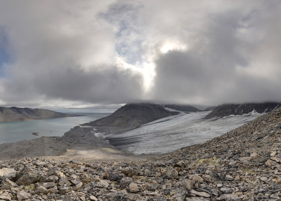
The innermost part of Trygghamna did not exist in the 17th century. Most likely, this area was covered by glaciers, which were much larger back then. Knuvlen is still surrounded by glaciers on several sides (Protektorbreen, Harrietbreen).
Knuvlen is not higher than 333 metres, but the slopes are quite steep, so you have to do a bit of work to enjoy this amazing view. The sandstone is frost-weathering to form huge, sharp boulders which are not exactly great for walking. But the view is worth the effort!
Photo gallery – Trygghamna: Knuvlen
Some impressions of Knuvlen and surroundings, from ascents in 2016 and 2019.
- gallery anchor link: #gallery_2833
Click on thumbnail to open an enlarged version of the specific photo.


BOOKS, CALENDAR, POSTCARDS AND MORE
This and other publishing products of the Spitsbergen publishing house in the Spitsbergen-Shop.
-

Norwegens arktischer Norden (1): Spitzbergen
Photobook: Norway's arctic islands. The text in this book is German. [shop url="https://shop.spitzbergen.de/en/polar-books/70-norwegens-arktischer-norden-1-aerial-arctic-9783937903262.html"] ← BackOrder now -
Norwegens arktischer Norden (2): Aerial Arctic
Lofoten, Jan Mayen and Spitsbergen from the air - Photobook: Norway's arctic islands. The text in this book is German, but there is very little text, so I am sure that you will enjoy it regardless which languages you read (or not).Order now -
Poster “Svalbardhytter”
The poster "Svalbardhytter" (70 x 100 cm) visualizes the diversity of Spitsbergen's huts in a range of arctic landscapes.Order now -
Book “Svalbardhytter”
The companion book for the Svalbardhytter poster. The poster visualises the diversity of Spitsbergen‘s huts and their stories in a range of Arctic landscapes. The book tells the stories of the huts in three languages.Order now -
Spitsbergen – Svalbard. The complete guidebook
Comprehensive guidebook about Spitsbergen. Background (wildlife, plants, geology, history etc.), practical information including travelling seasons, how to travel, description of settlements, routes and regions.Order now -
Rocks and Ice. Landscapes of the North
A geographical traveling accompaniment to Spitsbergen and East Greenland (68-74°N). This is the English edition of the German book "Steine und Eis".Order now -
East Greenland in Winter
Join an exciting journey with dog, skis and tent through the wintery wastes of East Greenland! We were five guys and a dog when we started in Ittoqqortoormiit, the northernmost one of two settlements on Greenland’s east coast.Order now -
Postcard set Spitsbergen (Svalbard)
12 Spitsbergen postcards in a beautifully designed tray. Individually numbered limited edition!Order now -
Limited edition postcard set Antarctica
12 postcards which come in a beautifully designed tray. Beautiful images from South Georgia across Antarctica from the Antarctic Peninsula to the Ross Sea and up to Macquarie Island and Campbell Island.Order now
last modification: 2023-09-08 ·
copyright: Rolf Stange


-
Books, Calendar, Postcards and more

-


