-
current
recommendations- Liefdefjord
New page dedicated to one of Spitsbergen's most beautiful fjords. Background information and many photos.
- New Spitsbergen guidebook
The new edition of my Spitsbergen guidebook is out and available now!
- Liefdefjord
New page dedicated to one of Spitsbergen's most beautiful fjords. Background information and many photos.
Page Structure
-
Spitsbergen-News
- Select Month
- June 2025
- May 2025
- April 2025
- March 2025
- February 2025
- January 2025
- December 2024
- November 2024
- October 2024
- September 2024
- August 2024
- July 2024
- June 2024
- May 2024
- April 2024
- March 2024
- February 2024
- January 2024
- December 2023
- November 2023
- October 2023
- September 2023
- August 2023
- July 2023
- June 2023
- May 2023
- April 2023
- March 2023
- February 2023
- January 2023
- December 2022
- November 2022
- October 2022
- September 2022
- August 2022
- July 2022
- June 2022
- May 2022
- April 2022
- March 2022
- February 2022
- January 2022
- December 2021
- November 2021
- October 2021
- September 2021
- August 2021
- July 2021
- June 2021
- May 2021
- April 2021
- March 2021
- February 2021
- January 2021
- December 2020
- November 2020
- October 2020
- September 2020
- August 2020
- July 2020
- June 2020
- May 2020
- April 2020
- March 2020
- February 2020
- January 2020
- December 2019
- November 2019
- October 2019
- September 2019
- August 2019
- July 2019
- June 2019
- May 2019
- April 2019
- March 2019
- February 2019
- January 2019
- December 2018
- November 2018
- October 2018
- September 2018
- August 2018
- July 2018
- June 2018
- May 2018
- April 2018
- March 2018
- February 2018
- January 2018
- December 2017
- November 2017
- October 2017
- September 2017
- August 2017
- July 2017
- June 2017
- May 2017
- April 2017
- March 2017
- February 2017
- January 2017
- December 2016
- November 2016
- October 2016
- September 2016
- August 2016
- July 2016
- June 2016
- May 2016
- April 2016
- March 2016
- February 2016
- January 2016
- December 2015
- November 2015
- October 2015
- September 2015
- August 2015
- July 2015
- June 2015
- May 2015
- April 2015
- March 2015
- February 2015
- January 2015
- December 2014
- November 2014
- October 2014
- September 2014
- August 2014
- July 2014
- June 2014
- May 2014
- April 2014
- March 2014
- February 2014
- January 2014
- December 2013
- November 2013
- October 2013
- September 2013
- August 2013
- July 2013
- June 2013
- May 2013
- April 2013
- March 2013
- February 2013
- January 2013
- December 2012
- November 2012
- October 2012
- September 2012
- August 2012
- July 2012
- June 2012
- May 2012
- April 2012
- March 2012
- February 2012
- January 2012
- December 2011
- November 2011
- October 2011
- September 2011
- August 2011
- May 2011
- April 2011
- March 2011
- February 2011
- January 2011
- December 2010
- November 2010
- September 2010
- August 2010
- July 2010
- June 2010
- May 2010
- April 2010
- March 2010
- February 2010
- November 2009
- October 2009
- August 2009
- July 2009
- June 2009
- May 2009
- April 2009
- March 2009
- February 2009
- January 2009
- December 2008
- November 2008
- October 2008
- August 2008
- July 2008
- June 2008
- May 2008
- April 2008
- March 2008
- February 2008
- April 2000
- Select Month
-
weather information
-
Newsletter

| Guidebook: Spitsbergen-Svalbard |
Home
→ * Photos, Panoramas, Videos and Webcams
→ Spitsbergen Panoramas
→ The Sveagruva area
→ Sveagruva
Sveagruva: a Norwegian coal mining settlement in Spitsbergen
360 degree panorama
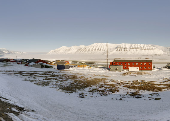
Together with Longyearbyen, Sveagruva was the main place for Norwegian coal mining in Spitsbergen during large parts of the 20th century and, with interruptions, until 2015. The coal occurrence was initially occupied in 1910 by the Swede Bertil Högbom for Jernkontoret og Trafikaktiebolaget Grängesberg-Oxelösund (Högbom was also the one who started Pyramiden in a similar way). The new occupation in Van Mijenfjord was called – surprise – “Sveagrufvan”, the “Swedish mine”. With a slightly different spelling, the name has survived until today, but the place is usually just referred to as “Svea” in common language.
Overview of the panoramas
Sveagruva Map
In 1911, the ubiquitous British Northern Exploration Company (Ernest Mansfield, yes, that was the story of Ny London on Blomstrandhalvøya in Kongsfjord) tried to get a foot in the door by building two cabins, but that did not have any further consequences.
- pano anchor link: #170425f_Sveagruva_12HDR
In 1917 the Swedish AB Spetsbergen Svenska Kolfält went ahead with first mining actitivies. But the property was sold as early as 1921 to the Svenska Stenkolsaktiebolaget Spetsbergen who enlarged and improved the mining facilities, but they also had to give up for economical reasons in 1925. Further activities were reduced to a small crew to guard the property until Nya Svenska Stenkolsaktiebolaget Spetsbergen made a new attempt with coal mining.
- pano anchor link: #170425f_Sveagruva_31HDR
The Norwegian history of Sveagruva started in 1934 when Store Norske Spitsbergen Kulkompani (SNSK) bought the place and the mine. At this time, the Norwegian government played an important and active role in mining in Spitsbergen, and a political wish to gain factual control over larger areas certainly played a role. Actually securing a reliable energy supply to north Norway was another important factor for aquiring Svea, a history similar to the development in Ny-Ålesund.
- pano anchor link: #170425f_Sveagruva_49HDR
The Second World War brought destruction also to Sveagruva when a German submarine attacked the settlement with gunfire (not during the large attack in 1943 during which Barentsburg and Longyearbyen were largely destroyed). The mine was soon opened again after the war but all activities ceased from 1949 to 1970 due to the poor economy. SNSK decided to focus on one of their places, and Longyearbyen, being Spitsbergen’s main settlement, was the obvious choice, as this was not only where the administration was located but shipping conditions were also much easier. Van Mijenfjord is protected from the open sea by the island of Akseløya, hence the fjord ice was lying there much longer in spring, making the shipping season shorter.
- pano anchor link: #170425f_Sveagruva_68HDR
Mining in Sveagruva was restarted in 1970 but did not continue without difficulties in the years to come. The place saw its best years after Svea Nord was opened in 2001. Here, coal seems with a thickness of up to 6 metres were mined, enabling a very profitable mining operation. A road over a glacier had to be build to operate Svea Nord, but this effort was more than balanced by the largest coal occurrence that was ever mined in Spitsbergen.
- pano anchor link: #170425fh_Sveagruva_33HDR
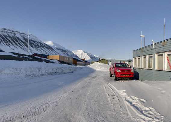
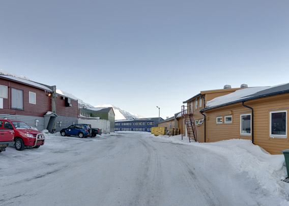
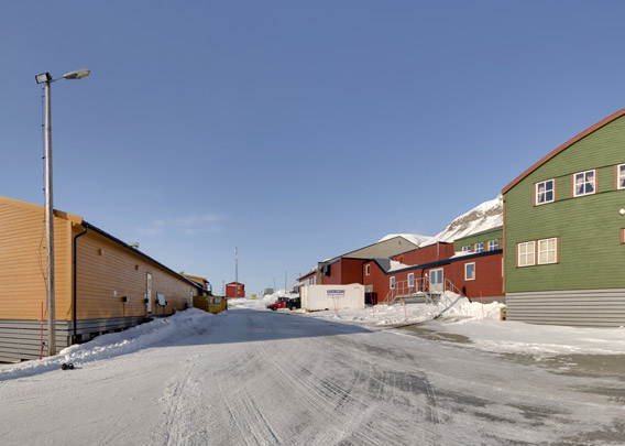
There was family life in Sveagruva during shorter periods in historical times, but Svea never fully developed to become a “normal” settlement with a more or less stable population of its own, with families and everything that comes with family live, such as Longyearbyen. In more recent times, workers lived during their shifts in Sveagruva, often for periods of 2 weeks, but they actually had their homes in Longyearbyen or even in mainland Norway. Hence, the infrastructure of the settlement never went beyond the needs of a company town, there was no public shop, no school, church or other public infrastructure. The flight connection to Longyearbyen enabled the miners to commute; during the winter, experienced snow mobile drivers can cover the distance on the ground in less than one hour (something the less experienced visitor, without good local knowledge, will never be able to accomplish).
- pano anchor link: #170426a_Sveagruva_01HDR
A new mine was opened in February 2013 at Lunckefjellet, north of Svea Nord. The first ton of coal was produced in November the same year, but that was just symbolic, as the Lunckefjellet mine was to never enter real production: economical difficulties forced SNSK in 2015 to run Lunckefjellet purely in a standby mode. In 2017, the Norwegian government, owner of the SNSK, decided not to finance further mining activities and then the political decision was made in Oslo to abandon coal mining in Svea altogether. Soon thereafter, coal prices started to increase again on the world market, and already in 2018 SNSK could celebrate a solid profit in mine 7 (Longyearbyen), even hiring miners again after several difficult years also there. It is safe to assume that quite a few Svea miners will have bitten their own asses while observing this development, but the government in Oslo did not accept any discussions about renewed mining activities in Svea. In contrast, the nearby Nordenskiöld Land National Park is planned to be enlarged to make sure nobody will ever start mining again in Sveagruva. The settlement itself and the mines have largely been cleared up and removed in 2019 and following years.
A coal pier was built at Kapp Amsterdam, 5 kilometres south of Sveagruva, where depths allow large cargo ships to go alongside.
To page: → The Sveagruva area → Sveagruva (settlement) → Svea Nord → Lunckefjellet → Kapp Amsterdam
BOOKS, CALENDAR, POSTCARDS AND MORE
This and other publishing products of the Spitsbergen publishing house in the Spitsbergen-Shop.
last modification: 2023-11-17 ·
copyright: Rolf Stange


