


-
current
recommendations- Liefdefjord
New page dedicated to one of Spitsbergen's most beautiful fjords. Background information and many photos.

- New Spitsbergen guidebook
The new edition of my Spitsbergen guidebook is out and available now!
- Liefdefjord
New page dedicated to one of Spitsbergen's most beautiful fjords. Background information and many photos.
-
weather information

| Guidebook: Spitsbergen-Svalbard |
Wigdehlpynten
An Old Red landscape in inner Woodfjord
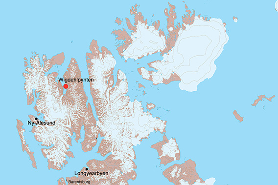
Wigdehlpynten is a flat little peninsula in inner Woodfjord. A little known and rarely visited place, but scenically beautiful (as the whole area) on a lovely day like this. Then, the sunlight will bring the colours out and it will make them shine: the mountains are carved out of Old Red Sandstone: deposited as sediment eroded from the Caledonian mountains, which were folded up a good 400 million years ago, during the Devonian (just roughly, 350-400 million years ago) in large areas of tectonic subsidence (“graben”). In this case, it is the so-called Andrée Land graben, after the part of Spitsbergen between Woodfjord and Wijdefjord. The reddish colour is derived from hematite, an iron oxide.
Panorama 1 – Wigdehlpynten
- pano anchor link: #1709017b_Wigdehlpynten_41HDR
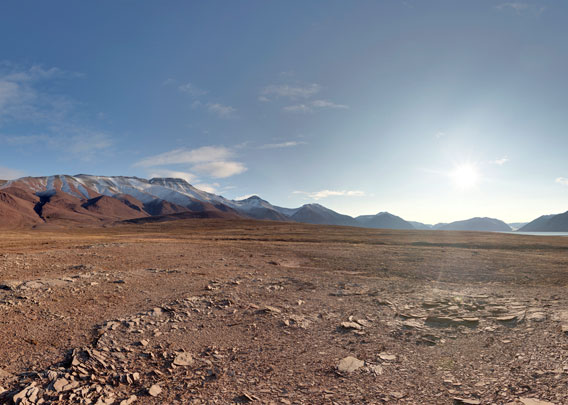
A fine summer day in this area, with a blue sky, green tundra and red mountains, is an unforgettably beautiful experience! If you have a sense for this kind of beauty …
Panorama 2 – Wigdehlpynten
- pano anchor link: #1709017b_Wigdehlpynten_59HDR
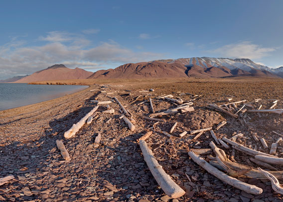
The second panorama explains the name Woodfjord, earlier known as Wood Bay: the name is derived from the large amounts of driftwood which come with the currents from Siberia across the Arctic Ocean. Good raw material, by the way, to produce Spitsbergen driftwood picture frames 🙂
Photo gallery Woodfjord: Wigdehlpynten
Some impressions from inner Woodfjord.
- gallery anchor link: #gallery_3578
Click on thumbnail to open an enlarged version of the specific photo.


BOOKS, CALENDAR, POSTCARDS AND MORE
This and other publishing products of the Spitsbergen publishing house in the Spitsbergen-Shop.
-

Norwegens arktischer Norden (1): Spitzbergen
Photobook: Norway's arctic islands. The text in this book is German. [shop url="https://shop.spitzbergen.de/en/polar-books/70-norwegens-arktischer-norden-1-aerial-arctic-9783937903262.html"] ← BackOrder now -
Norwegens arktischer Norden (2): Aerial Arctic
Lofoten, Jan Mayen and Spitsbergen from the air - Photobook: Norway's arctic islands. The text in this book is German, but there is very little text, so I am sure that you will enjoy it regardless which languages you read (or not).Order now -
Poster “Svalbardhytter”
The poster "Svalbardhytter" (70 x 100 cm) visualizes the diversity of Spitsbergen's huts in a range of arctic landscapes.Order now -
Book “Svalbardhytter”
The companion book for the Svalbardhytter poster. The poster visualises the diversity of Spitsbergen‘s huts and their stories in a range of Arctic landscapes. The book tells the stories of the huts in three languages.Order now -
Spitsbergen – Svalbard. The complete guidebook
Comprehensive guidebook about Spitsbergen. Background (wildlife, plants, geology, history etc.), practical information including travelling seasons, how to travel, description of settlements, routes and regions.Order now -
Rocks and Ice. Landscapes of the North
A geographical traveling accompaniment to Spitsbergen and East Greenland (68-74°N). This is the English edition of the German book "Steine und Eis".Order now -
East Greenland in Winter
Join an exciting journey with dog, skis and tent through the wintery wastes of East Greenland! We were five guys and a dog when we started in Ittoqqortoormiit, the northernmost one of two settlements on Greenland’s east coast.Order now -
Postcard set Spitsbergen (Svalbard)
12 Spitsbergen postcards in a beautifully designed tray. Individually numbered limited edition!Order now -
Limited edition postcard set Antarctica
12 postcards which come in a beautifully designed tray. Beautiful images from South Georgia across Antarctica from the Antarctic Peninsula to the Ross Sea and up to Macquarie Island and Campbell Island.Order now
last modification: 2025-03-27 ·
copyright: Rolf Stange


-
Books, Calendar, Postcards and more

-


