-
current
recommendations- Liefdefjord
New page dedicated to one of Spitsbergen's most beautiful fjords. Background information and many photos.

- New Spitsbergen guidebook
The new edition of my Spitsbergen guidebook is out and available now!

- Liefdefjord
New page dedicated to one of Spitsbergen's most beautiful fjords. Background information and many photos.
Page Structure
-
Spitsbergen-News
- Select Month
- April 2025
- March 2025
- February 2025
- January 2025
- December 2024
- November 2024
- October 2024
- September 2024
- August 2024
- July 2024
- June 2024
- May 2024
- April 2024
- March 2024
- February 2024
- January 2024
- December 2023
- November 2023
- October 2023
- September 2023
- August 2023
- July 2023
- June 2023
- May 2023
- April 2023
- March 2023
- February 2023
- January 2023
- December 2022
- November 2022
- October 2022
- September 2022
- August 2022
- July 2022
- June 2022
- May 2022
- April 2022
- March 2022
- February 2022
- January 2022
- December 2021
- November 2021
- October 2021
- September 2021
- August 2021
- July 2021
- June 2021
- May 2021
- April 2021
- March 2021
- February 2021
- January 2021
- December 2020
- November 2020
- October 2020
- September 2020
- August 2020
- July 2020
- June 2020
- May 2020
- April 2020
- March 2020
- February 2020
- January 2020
- December 2019
- November 2019
- October 2019
- September 2019
- August 2019
- July 2019
- June 2019
- May 2019
- April 2019
- March 2019
- February 2019
- January 2019
- December 2018
- November 2018
- October 2018
- September 2018
- August 2018
- July 2018
- June 2018
- May 2018
- April 2018
- March 2018
- February 2018
- January 2018
- December 2017
- November 2017
- October 2017
- September 2017
- August 2017
- July 2017
- June 2017
- May 2017
- April 2017
- March 2017
- February 2017
- January 2017
- December 2016
- November 2016
- October 2016
- September 2016
- August 2016
- July 2016
- June 2016
- May 2016
- April 2016
- March 2016
- February 2016
- January 2016
- December 2015
- November 2015
- October 2015
- September 2015
- August 2015
- July 2015
- June 2015
- May 2015
- April 2015
- March 2015
- February 2015
- January 2015
- December 2014
- November 2014
- October 2014
- September 2014
- August 2014
- July 2014
- June 2014
- May 2014
- April 2014
- March 2014
- February 2014
- January 2014
- December 2013
- November 2013
- October 2013
- September 2013
- August 2013
- July 2013
- June 2013
- May 2013
- April 2013
- March 2013
- February 2013
- January 2013
- December 2012
- November 2012
- October 2012
- September 2012
- August 2012
- July 2012
- June 2012
- May 2012
- April 2012
- March 2012
- February 2012
- January 2012
- December 2011
- November 2011
- October 2011
- September 2011
- August 2011
- May 2011
- April 2011
- March 2011
- February 2011
- January 2011
- December 2010
- November 2010
- September 2010
- August 2010
- July 2010
- June 2010
- May 2010
- April 2010
- March 2010
- February 2010
- November 2009
- October 2009
- August 2009
- July 2009
- June 2009
- May 2009
- April 2009
- March 2009
- February 2009
- January 2009
- December 2008
- November 2008
- October 2008
- August 2008
- July 2008
- June 2008
- May 2008
- April 2008
- March 2008
- February 2008
- April 2000
- Select Month
-
weather information
-
Newsletter

| Guidebook: Spitsbergen-Svalbard |
Home → Spitsbergen information → Islands: Spitsbergen & Co. → Spitsbergen (Southern part) → Bellsund – Van Mijenfjord …
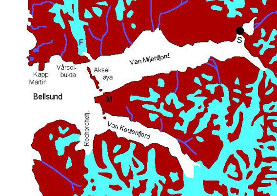
Bellsund - Van Mijenfjord - Van Keulenfjord

F = Fridtjofbreen (-glacier), Fridtjofhamna (the bay near Fridtjofbreen), S = Sveagruva, M = Midterhukfjellet
General: Scenically very varied fjord system with several branches. There are some historically interesting sites. The land south of Bellsund and Van Keulenfjord is part of the South Spitsbergen National Park.
For more, detailed information: the Guidebook Spitsbergen-Svalbard

Geology: Geologically, this is for me the ‘classical’ west coast fjord, with a nice cross section through Earth history of Spitsbergen from the west coast to the inner part of the fjord. Near the west coast, you find the pre-Devonian basement with quarzites, phyllites and shist. There are different kinds of ores and minerals, which led to exploration and trial mining in the early 20th century, but without any results. The devonian Old Red is missing in the area, so Carboniferous konglomerates and breccias lie directly on the basement, followed by a succession similar to the famous ‘Festningen section‘, with sediments spanning the period from Carboniferous to lower Tertiary. The tertiary sediments are exposed east of the line Fridtjofbreen-Midterhuken, they contain thick coals seams (similar to the geology around Longyearbyen), which were mined in Sveagruva (click here for more information about Svea).
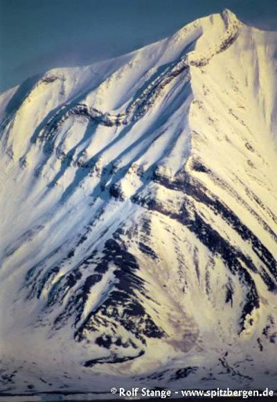
The tectonic deformation of the sediments is interesting. Tectonic activity during the opening of the north Atlantic took place west of the west coast (well, makes sense, as that’s where the Atlantic is). The nearer to the coast, the stronger are uplift and deformation of the rocks. Close to the coast, uplift was strong enough to expose the basement, which is buried under several kilometres of sedimentary cover in central Spitsbergen. Close to the basement, the sedimentary cover rocks are strongly deformed and dip vertically with a N-S trend and expose nice folds and faults, especially beautiful on the northern slope of the Midterhukfjellet. The deformation becomes very obvious whereever the rocks are very hard, such as the Permian limestones of the Kapp Starostin Formation at Akseløya. Further to the east, where the sediments have preserved their original, horizontal position, you find the classical plateau-shaped mountains.
Folded layers exposed on the northern slopes of Midterhukfjellet.
Landscape: Nicely varied because of the geological history. A wide range of ‘typical Svalbard-landscapes’ can be seen within a relatively short distance, starting with the coastal plains forming the west coast to the jagged mountains nearby to the plateau-mountain landscape of central and eastern Spitsbergen as well as Barents– and Edgøya. The transition zone is especially fascinating, with its strongly deformed sediments. Hard, vertically dipping sediments stand out like walls in the landscape and form the elongated Akseløya as well as part of the Midterhukfjellet with its beautiful fold patterns to some nice capes and islands in the Van Keulenfjord. Should you ever have the chance to go inland into Folddalen just southeast of Midterhukfjellet, you will see some nice waterfalls cascading down the hard, steep-standing sedimentary layers.
The ‘hinterland’, especially in the southern part, is more strongly glaciated than the surroundings of Longyearbyen, but less so than northwestern Spitsbergen or the Hornsund-area. This means that the Bellsund is not exactly the classical place in Svalbard to experience large glaciers, but there are still some nice ones, such as the Fridtjovbreen which can be reached within a few days trekking from Longyearbyen or Barentsburg.
Near the west coast, you find wide coastal plains, which may appear to be barren and boring, but have a lot to offer to those who can appreciate the many beautiful, little details: a nice piece of driftwood, an old whalebone near the beach, a tranquil tundra pond with a breeding Red-throated diver and other birdlife, well-developed series of old beach ridges (which are partly very nice to walk on) etc. Especially nice fossil beach ridges with very obvious ice wedges can be seen in the entrance area of the Van Keulenfjord.
Flora and Fauna: Very nice and rich tundra near Vårsolbukta on the northern side of Bellsund. The outer coast is under the influence of the gulf stream, and fertilisation by a nearby, large birdcliff will play a role. This tundra is an important place where geese gather in the early summer, and fox and reindeer are abundant. The birdcliff itself is high up on the cliffs of Ingeborgfjellet (west of Fridtjovbreen) and not directly accessible, but the noise level is impressive. There are nice tundra areas also in other places around the Bellsund (Recherchefjord, Van Keulenfjord). Polar bears roam the area – be careful…
History: Bellsund was one of the first fjords in Spitsbergen to be visited and used by whalers in the early 17th century. There are remains of whaling stations, e.g. in the Recherchefjord. On several occasions, whalers were forced to winter and survived miraculously. Also the Pomors used the area as a hunting ground for centuries; there are several remains of their hunting stations near the west coast, especially north of Bellsund. Here, some of them may be older than 1596, the date of Barents‘ discovery of Spitsbergen.
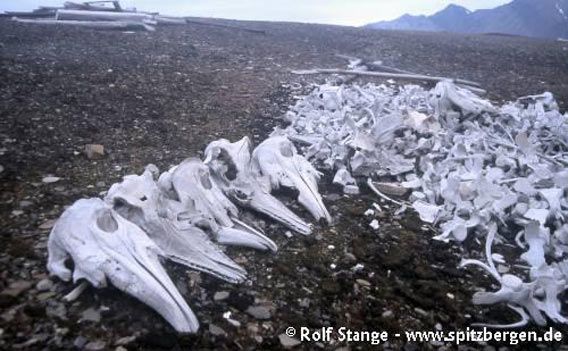
Norwegian trappers liked the area because of its strong fox populations. Even Belugas (white whales) were hunted in the Van Keulenfjord; today their bones are bleaching in the sun and remined us of the lack of wisdom of those days in Spitsbergen.

Beluga bones at Ahlstrandhalvøya, Van Keulenfjord.
In the early 20th century, mineral occurrences attracted more or less serious mining companies; some of these occurrences did exist, but turned out to be minor and/or of inferiour quality, other ones didn’t exist at all. There were hopes for zinc, gold, coal, iron, asbestos. Remains of trial mining can still be seen on both north and south side of the Bellsund, silent witnesses from the ‘gold rush period’ in the arctic (for more details, check out my book Rocks and Ice).
Photo-Gallery: Bellsund
- gallery anchor link: #gallery_392
Click on thumbnail to open an enlarged version of the specific photo.
BOOKS, CALENDAR, POSTCARDS AND MORE
This and other publishing products of the Spitsbergen publishing house in the Spitsbergen-Shop.
last modification: 2019-03-26 ·
copyright: Rolf Stange


