


-
current
recommendations- Liefdefjord
New page dedicated to one of Spitsbergen's most beautiful fjords. Background information and many photos.

- New Spitsbergen guidebook
The new edition of my Spitsbergen guidebook is out and available now!
- Liefdefjord
New page dedicated to one of Spitsbergen's most beautiful fjords. Background information and many photos.
-
weather information

| Guidebook: Spitsbergen-Svalbard |
Gipsdalen
A large valley in Bünsow Land

Gipsdalen is a large valley in Bünsow Land, between Billefjord and Tempelfjord.
The large peninsula between Billefjord and Sassenfjord / Tempelfjord is called Bünsow Land. This is one of the most scenic areas of Spitsbergen.
The large Gipsdalen valley runs through the centre of Bünsow Land. It has some interesting scenic, geological and historical features: The water solubility of the carbonate rocks causes them to dissolve underground. Geomorphologically, this leads to karst formation, which can include caves and, through their collapse, sinkholes (collapse funnels on the surface, also known as dolines). Rivers can run underground in places. There are no known caves in Gipsdalen, but it can be assumed that there are some underground.
- pano anchor link: #Gipsdalen_01Mai13_01
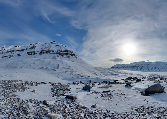
The wide, beautiful Gipsdalen is part of the usual winter route from Longyearbyen to the north, that is to Pyramiden or to Wijdefjord or to northeastern Spitsbergen: Newtontoppen, Atomfjella or Verlegenhuken. Here the moraine of Burn Murdochbreen.
The Scottish SSS (Scottish Spitsbergen Syndicate), in which the well-known Scottish polar explorer William Speirs Bruce was involved, explored coal deposits in Gipsdalen in the early 20th century. A few ruined huts, also far from the coast in the valley, and a rusty tractor on the shore still bear witness to this. However, there was no mining.
BOOKS, CALENDAR, POSTCARDS AND MORE
This and other publishing products of the Spitsbergen publishing house in the Spitsbergen-Shop.
-

Norwegens arktischer Norden (1): Spitzbergen
Photobook: Norway's arctic islands. The text in this book is German. [shop url="https://shop.spitzbergen.de/en/polar-books/70-norwegens-arktischer-norden-1-aerial-arctic-9783937903262.html"] ← BackOrder now -
Norwegens arktischer Norden (2): Aerial Arctic
Lofoten, Jan Mayen and Spitsbergen from the air - Photobook: Norway's arctic islands. The text in this book is German, but there is very little text, so I am sure that you will enjoy it regardless which languages you read (or not).Order now -
Poster “Svalbardhytter”
The poster "Svalbardhytter" (70 x 100 cm) visualizes the diversity of Spitsbergen's huts in a range of arctic landscapes.Order now -
Book “Svalbardhytter”
The companion book for the Svalbardhytter poster. The poster visualises the diversity of Spitsbergen‘s huts and their stories in a range of Arctic landscapes. The book tells the stories of the huts in three languages.Order now -
Spitsbergen – Svalbard. The complete guidebook
Comprehensive guidebook about Spitsbergen. Background (wildlife, plants, geology, history etc.), practical information including travelling seasons, how to travel, description of settlements, routes and regions.Order now -
Rocks and Ice. Landscapes of the North
A geographical traveling accompaniment to Spitsbergen and East Greenland (68-74°N). This is the English edition of the German book "Steine und Eis".Order now -
East Greenland in Winter
Join an exciting journey with dog, skis and tent through the wintery wastes of East Greenland! We were five guys and a dog when we started in Ittoqqortoormiit, the northernmost one of two settlements on Greenland’s east coast.Order now -
Postcard set Spitsbergen (Svalbard)
12 Spitsbergen postcards in a beautifully designed tray. Individually numbered limited edition!Order now -
Limited edition postcard set Antarctica
12 postcards which come in a beautifully designed tray. Beautiful images from South Georgia across Antarctica from the Antarctic Peninsula to the Ross Sea and up to Macquarie Island and Campbell Island.Order now
last modification: 2025-02-06 ·
copyright: Rolf Stange


-
Books, Calendar, Postcards and more

-


