


-
current
recommendations- Liefdefjord
New page dedicated to one of Spitsbergen's most beautiful fjords. Background information and many photos.

- New Spitsbergen guidebook
The new edition of my Spitsbergen guidebook is out and available now!
- Liefdefjord
New page dedicated to one of Spitsbergen's most beautiful fjords. Background information and many photos.
-
weather information

| Guidebook: Spitsbergen-Svalbard |
Home
→ * Photos, Panoramas, Videos and Webcams
→ Spitsbergen Panoramas
→ The Sveagruva area
→ Kapp Amsterdam
Kapp Amsterdam
The harbour of Sveagruva
The lagoon Braganzavågen near Svea is very shallow and thus not navigable. Hence, there is a harbour at Kapp Amsterdam in Van Mijenfjord, about 5 kilometres south of the settlement. There is not just a pier at Kap Amsterdam, but also a large storage area, so it bears the character of heavy industry just as Sveagruva itself.
- pano anchor link: #170425fg_Kapp-Amsterdam_21HDR
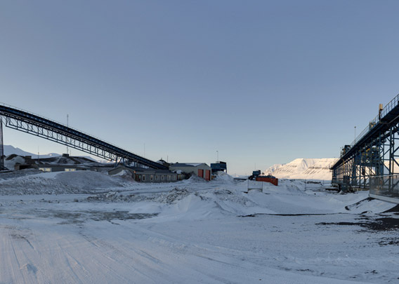
The “harbour” is accessible only in summer and autumn, as Van Mijenfjord tends to freeze sold during the winter and spring because the fjord is protected from the open sea by Akseløya, a long, narrow island that almost cuts the fjord off from the outer coast. The ice cover can accordingly build up with less disturbance by waves and currents than in other fjords. When the harbour had to be accessed by ships during the winter, this could only be done with the help of an ice breaker, something that is avoided these days as much as possible for environmental reasons.
- pano anchor link: #170425fg_Kapp-Amsterdam_43HDR
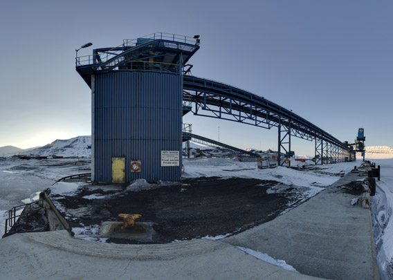
The clean-up of Sveagruva includes the facilities at Kapp Amsterdam, so nothing or at least not much will remain here in the end. But this will be the last part of the process, as the harbour is obviously needed to ship everything out.
To page: → The Sveagruva area → Sveagruva (settlement) → Svea Nord → Lunckefjellet → Kapp Amsterdam
BOOKS, CALENDAR, POSTCARDS AND MORE
This and other publishing products of the Spitsbergen publishing house in the Spitsbergen-Shop.
-

Norwegens arktischer Norden (1): Spitzbergen
Photobook: Norway's arctic islands. The text in this book is German. [shop url="https://shop.spitzbergen.de/en/polar-books/70-norwegens-arktischer-norden-1-aerial-arctic-9783937903262.html"] ← BackOrder now -
Norwegens arktischer Norden (2): Aerial Arctic
Lofoten, Jan Mayen and Spitsbergen from the air - Photobook: Norway's arctic islands. The text in this book is German, but there is very little text, so I am sure that you will enjoy it regardless which languages you read (or not).Order now -
Poster “Svalbardhytter”
The poster "Svalbardhytter" (70 x 100 cm) visualizes the diversity of Spitsbergen's huts in a range of arctic landscapes.Order now -
Book “Svalbardhytter”
The companion book for the Svalbardhytter poster. The poster visualises the diversity of Spitsbergen‘s huts and their stories in a range of Arctic landscapes. The book tells the stories of the huts in three languages.Order now -
Spitsbergen – Svalbard. The complete guidebook
Comprehensive guidebook about Spitsbergen. Background (wildlife, plants, geology, history etc.), practical information including travelling seasons, how to travel, description of settlements, routes and regions.Order now -
Rocks and Ice. Landscapes of the North
A geographical traveling accompaniment to Spitsbergen and East Greenland (68-74°N). This is the English edition of the German book "Steine und Eis".Order now -
East Greenland in Winter
Join an exciting journey with dog, skis and tent through the wintery wastes of East Greenland! We were five guys and a dog when we started in Ittoqqortoormiit, the northernmost one of two settlements on Greenland’s east coast.Order now -
Postcard set Spitsbergen (Svalbard)
12 Spitsbergen postcards in a beautifully designed tray. Individually numbered limited edition!Order now -
Limited edition postcard set Antarctica
12 postcards which come in a beautifully designed tray. Beautiful images from South Georgia across Antarctica from the Antarctic Peninsula to the Ross Sea and up to Macquarie Island and Campbell Island.Order now
last modification: 2020-01-29 ·
copyright: Rolf Stange


-
Books, Calendar, Postcards and more

-


