


-
current
recommendations- Liefdefjord
New page dedicated to one of Spitsbergen's most beautiful fjords. Background information and many photos.

- New Spitsbergen guidebook
The new edition of my Spitsbergen guidebook is out and available now!
- Liefdefjord
New page dedicated to one of Spitsbergen's most beautiful fjords. Background information and many photos.
-
weather information

| Guidebook: Spitsbergen-Svalbard |
Kvedfjordbukta
360 panorama images from Spitsbergen's west coast

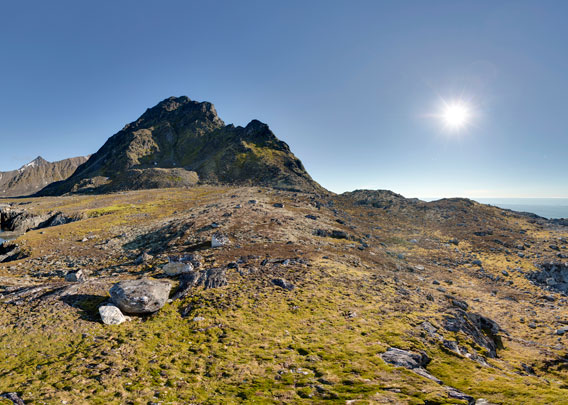
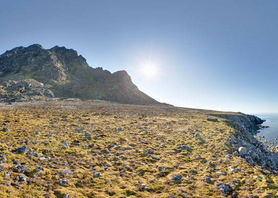
Kvedfjordbukta is located on the northern west coast of Spitsbergen.
Kvedfjordbukta ist an open bay on the west coast of Spitsbergen, between Krossfjord and Magdalenefjord. This rather hostile coastal stretch is very exposed. It consists of either steep rock slopes and some boulder beaches and glaciers. There are seven major glaciers in this area, and they all used to reach the sea, so the whalers named this coast “The seven icebergs”, today “Dei Sju Isfjella” in Norwegian. All these glaciers have retreated in recent decades, so not all of them reach the sea anymore.
- pano anchor link: #170731f_Kvedfjordbukta_007HDR
This coast could be a challenge on the way north as there was no shelter in case of sudden storms. Hamburgbukta further north is the first place where smaller vessels may anchor, but then you have already almost reached Magdalenefjord with the historically well-known and mostly well-sheltered anchorage at Trinityhamna, east of Gravneset.
- pano anchor link: #180816a_Isoyane_301HDR
The vegetation looks rich and pristine. It is obvious that there is not a lot of trampling here, and there is a lot of fertilization from the little auks that are breeding on the steep scree slopes in large numbers.
- pano anchor link: #170731f_Kvedfjordbukta_109HDR

Trappers have built a hut in Kvedfjordbukta in the 1920s to have a link between Krossfjord and Kongsfjord to the south, where Ny-Ålesund provides Spitsbergen’s northernmost outlier of zivilisation, and the hunting grounds further north, in Magdalenefjord and Smeerenburgfjord. There was another hut at Ræderfjellet (Tredjebreen). Both have disappeared and there is nothing left but a very few scattered remains so you can barely see where they might once have been.
Kvedfjordbukta: Photo gallery
A collection of photos taken during two visits to Kvedfjordbukta, both obviously under perfect weather conditions.
- gallery anchor link: #gallery_2540
Click on thumbnail to open an enlarged version of the specific photo.


BOOKS, CALENDAR, POSTCARDS AND MORE
This and other publishing products of the Spitsbergen publishing house in the Spitsbergen-Shop.
-

Norwegens arktischer Norden (1): Spitzbergen
Photobook: Norway's arctic islands. The text in this book is German. [shop url="https://shop.spitzbergen.de/en/polar-books/70-norwegens-arktischer-norden-1-aerial-arctic-9783937903262.html"] ← BackOrder now -
Norwegens arktischer Norden (2): Aerial Arctic
Lofoten, Jan Mayen and Spitsbergen from the air - Photobook: Norway's arctic islands. The text in this book is German, but there is very little text, so I am sure that you will enjoy it regardless which languages you read (or not).Order now -
Poster “Svalbardhytter”
The poster "Svalbardhytter" (70 x 100 cm) visualizes the diversity of Spitsbergen's huts in a range of arctic landscapes.Order now -
Book “Svalbardhytter”
The companion book for the Svalbardhytter poster. The poster visualises the diversity of Spitsbergen‘s huts and their stories in a range of Arctic landscapes. The book tells the stories of the huts in three languages.Order now -
Spitsbergen – Svalbard. The complete guidebook
Comprehensive guidebook about Spitsbergen. Background (wildlife, plants, geology, history etc.), practical information including travelling seasons, how to travel, description of settlements, routes and regions.Order now -
Rocks and Ice. Landscapes of the North
A geographical traveling accompaniment to Spitsbergen and East Greenland (68-74°N). This is the English edition of the German book "Steine und Eis".Order now -
East Greenland in Winter
Join an exciting journey with dog, skis and tent through the wintery wastes of East Greenland! We were five guys and a dog when we started in Ittoqqortoormiit, the northernmost one of two settlements on Greenland’s east coast.Order now -
Postcard set Spitsbergen (Svalbard)
12 Spitsbergen postcards in a beautifully designed tray. Individually numbered limited edition!Order now -
Limited edition postcard set Antarctica
12 postcards which come in a beautifully designed tray. Beautiful images from South Georgia across Antarctica from the Antarctic Peninsula to the Ross Sea and up to Macquarie Island and Campbell Island.Order now
last modification: 2022-11-10 ·
copyright: Rolf Stange


-
Books, Calendar, Postcards and more

-


