


-
current
recommendations- Liefdefjord
New page dedicated to one of Spitsbergen's most beautiful fjords. Background information and many photos.

- New Spitsbergen guidebook
The new edition of my Spitsbergen guidebook is out and available now!
- Liefdefjord
New page dedicated to one of Spitsbergen's most beautiful fjords. Background information and many photos.
-
weather information

| Guidebook: Spitsbergen-Svalbard |
Home
→ * Photos, Panoramas, Videos and Webcams
→ Spitsbergen Panoramas
→ Hiorthfjellgruva: Sneheim
Hiorthfjellgruva: Sneheim
Early 20th century coal mining on Hiorthfjellet, Adventfjord
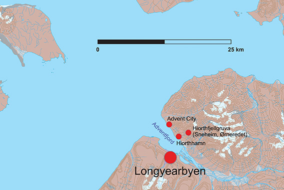
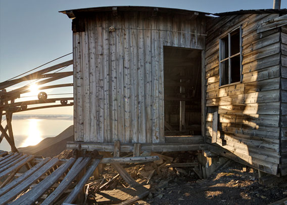
The old coal mine Hiorthfjellgruve (Sneheim, Ørneredet) is located on Hiorthfjellet on the north side of Adventfjord, opposite of Longyearbyen.
At the beginning of the 20th century, coal was mined in Adventfjord not only in Longyear City, as Longyearbyen was called until 1926, but also in Advent City and at Hiorthfjellet, the iconic mountain opposite Longyearbyen. The mine at Advent City is older and most of the buildings there were removed and transported further into the fjord to Hiorthhamn in 1917 to be reused there.

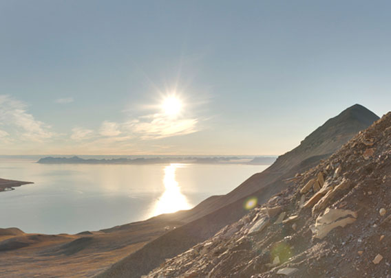
You have to look closely, preferably with binoculars, to see the installations Hiortfjellgruve from Longyearbyen. The mine (‘Sneheim’) is on the left and the workers‘ accommodation and mess hall (’Ørneredet”) on the right.
The naming of the facilities at the actual mine on the slope of Hiorthfjellet is somewhat confusing. Officially, the mine was called Hiorthfjellgruve (Hiorthfjell mine), but locally it was known as Sneheim (‘snow home’). More recently, the name Ørneredet (‘eagle’s nest’) has become established, but this has no historical reference.
On this page you can see pictures of and read about the entrance of the old mine. For the sake of easier overview, there is a separate page dedicated to the accommodation and mess hall, here referred to as ‘Ørneredet’.
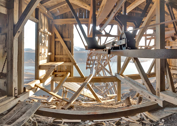
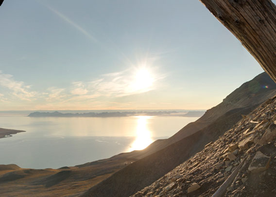
Near the shore in Hiorthhamn there are still a few old buildings from that time and above all the cableway station / loading plant for the coal. However, this was mined high up on the mountain, 582 metres above sea level!
- pano anchor link: #a9p_Hiorthfjellet_23Aug14_386HDR
The effort required to get the building materials from the shore up to this height is almost unimaginable. It’s exhausting enough to hike up there when you’re only carrying camera equipment, something to eat and the obligatory rifle.
- pano anchor link: #a9p_Hiorthfjellet_23Aug14_427HDR
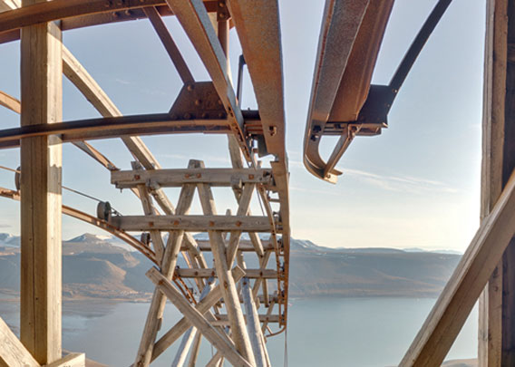
Until the cable railway, which could then be used to transport coal and materials, was built, every board, beam, nail and whatever else was needed had to be transported up on foot.
- pano anchor link: #a9p_Hiorthfjellet_23Aug14_463HDR
The workers also had to walk to the mine. Some are said to have stayed up there for months without ever getting to the actual settlement on the shore because they felt the effort would have been disproportionate. They were able to walk the few hundred metres between Sneheim (mine) and Ørneredet (mess hall, accommodation) further east at the same altitude, quite comfortably. ‘Comfortable’ is, however, a relative term, the miners at Hiorthfjellet were certainly no wimps.

The Hiorthfjellgruve ‘Sneheim’ (mine in front, barracks and mess hall behind).
What an adventure to build mining facilities in this terrain at an altitude of 580 metres!
There were even rumours that at least one worker had lived up there for seven or even twelve years without leaving the facility high up on Hiorthfjellet. This is obviously false: for a start, the mine was not in operation for that long. However, it is plausible that at least some of the workers spent the winter up there. In the early 1920s, it is said to have been customary to spend six days in a row up there and the Sunday when no work was being done in the more comfortable Hiorthhamn settlement. But some people may have thought that a day off down at the fjord was not worth the strenuous trip down and back up again.
The mining adventure in Sneheim came to an end in 1921. Mining was too difficult and expensive, and the coal deposits were not good enough. From 1923 to 1925 there was another attempt to mine coal in Sneheim, but there were only around 10 workers on site and the sporadic visits and trials from 1922 to 1935 produced just 10,000 tonnes of coal.
A final attempt was made in 1937-40, during which time workers are said to have spent more than a week at a stretch in Sneheim. In 1937 there were 24 people in Hiorthhamn / Sneheim. At this time, Hiorthhamn was renamed Moskushamn, as some muskoxen from Greenland had been released there some years ago (they would eventually die out in the 1980s). Perhaps the new owners wanted to distance themselves from the previous owner. In 1939-40, there were initially 73 people on site, but many of them left in the autumn due to the growing threat of war in Europe.
The mine has been decaying ever since.
- pano anchor link: #a9p_Hiorthfjellet_23Aug14_499HDR
The old path between Sneheim (mine) and Ørneredet (accommodation) was still easy to walk on in 2014, but has since partly slipped away. You should consider carefully if you venture in the steep terrain, where rocks or entire slopes can start moving at any time, and when in doubt, stay away from potentially dangerous areas. A digital trip to Ørneredet is just one perfectly safe mouse click away.
- pano anchor link: #a9p_Hiorthfjellet_23Aug14_535HDR
Main source: Leif Johnny Johannessen (2006): Hiorthhamn. Kulldrift under vanskelige forhold. Published by Sysselmannen på Svalbard, Longyearbyen.
The mine on Hiorthfjell: Sneheim
Last but not least, a few classic photo impressions of the Sneheim / Hiorthfjellgruve mine. The pictures are from 2014 and 2024.
- gallery anchor link: #gallery_3408
Click on thumbnail to open an enlarged version of the specific photo.


BOOKS, CALENDAR, POSTCARDS AND MORE
This and other publishing products of the Spitsbergen publishing house in the Spitsbergen-Shop.
-

Norwegens arktischer Norden (1): Spitzbergen
Photobook: Norway's arctic islands. The text in this book is German. [shop url="https://shop.spitzbergen.de/en/polar-books/70-norwegens-arktischer-norden-1-aerial-arctic-9783937903262.html"] ← BackOrder now -
Norwegens arktischer Norden (2): Aerial Arctic
Lofoten, Jan Mayen and Spitsbergen from the air - Photobook: Norway's arctic islands. The text in this book is German, but there is very little text, so I am sure that you will enjoy it regardless which languages you read (or not).Order now -
Poster “Svalbardhytter”
The poster "Svalbardhytter" (70 x 100 cm) visualizes the diversity of Spitsbergen's huts in a range of arctic landscapes.Order now -
Book “Svalbardhytter”
The companion book for the Svalbardhytter poster. The poster visualises the diversity of Spitsbergen‘s huts and their stories in a range of Arctic landscapes. The book tells the stories of the huts in three languages.Order now -
Spitsbergen – Svalbard. The complete guidebook
Comprehensive guidebook about Spitsbergen. Background (wildlife, plants, geology, history etc.), practical information including travelling seasons, how to travel, description of settlements, routes and regions.Order now -
Rocks and Ice. Landscapes of the North
A geographical traveling accompaniment to Spitsbergen and East Greenland (68-74°N). This is the English edition of the German book "Steine und Eis".Order now -
East Greenland in Winter
Join an exciting journey with dog, skis and tent through the wintery wastes of East Greenland! We were five guys and a dog when we started in Ittoqqortoormiit, the northernmost one of two settlements on Greenland’s east coast.Order now -
Postcard set Spitsbergen (Svalbard)
12 Spitsbergen postcards in a beautifully designed tray. Individually numbered limited edition!Order now -
Limited edition postcard set Antarctica
12 postcards which come in a beautifully designed tray. Beautiful images from South Georgia across Antarctica from the Antarctic Peninsula to the Ross Sea and up to Macquarie Island and Campbell Island.Order now
last modification: 2024-12-17 ·
copyright: Rolf Stange


-
Books, Calendar, Postcards and more

-


