


-
current
recommendations- Liefdefjord
New page dedicated to one of Spitsbergen's most beautiful fjords. Background information and many photos.

- New Spitsbergen guidebook
The new edition of my Spitsbergen guidebook is out and available now!
- Liefdefjord
New page dedicated to one of Spitsbergen's most beautiful fjords. Background information and many photos.
-
weather information

| Guidebook: Spitsbergen-Svalbard |
Vibebukta
Panorama of a polar desert on Nordaustand
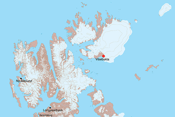
Vibebukta is a wide-open bay on the south coast of Nordaustland.

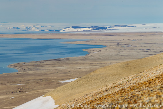
View over a river and lagoon landscape in Vibebukta towards Bråsvellbreen.
It is neighbouring the large glacier Bråsvellbreen, which is part of the huge ice cap Austfonna; Vibebukta is the last part of ice-free land next to the glacier front which characterises the coastline for more than 100 kilometers to the east and northeast from here. This “neighbourhood” alone would be enough to make Vibebukta a very specia
- pano anchor link: #180721b_Vibebukta_81HDR

Wide coastal plain in Vibebukta. The small, former river beds – now dry – have somewhat more vegetation than the surroundings, mostly algae.
The south coast of Nordaustland is a very barren and wide-open landscape. At a first, distant glance it may appear rather unspectacular: a wide, empty plain, and behind that, yellow-brownish hillslopes and some snow fields rising up to very modest heights, with the ice cap in the far distance. There is hardly any vegetation; the few flowers are mostly saxifraga or Svalbard poppy.
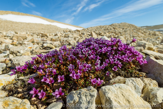
Purple saxifrage in Vibebukta.
Vibebukta: an inaccessible landscape
But on a closer look, Vibebukta reveals a scenery of stunning beauty – at least to those who have an eye for details. It is, in my modest opinion, actually one of the most beautiful places in the whole archipelago of Svalbard. Vibebukta is, however, not an easy place to get to. Getting to the general area is one thing – challenging enough – and getting into an operational distance is yet another one. Considering the widely shallow, poorly charted waters, this is something generally reserved for small vessels and captains who can make use of local knowledge. And in the end, it is up to weather, ice and the potential presence of polar bears anyway if a landing is an option or not.
- pano anchor link: #a5k_Vibebukta_25Juli14_128HDR

Panorama: View over Vibebukta from a rocky hillslope.
It needs some luck to be able to explore this place in situ. But when it works, it is absolutely worth the effort!
View over the coastal plain in Vibebukta from the hillslopes further inland.
It starts with the seemingly endless dimensions of the landscape, which can be a bit overwhelming especially when you spend some silent moments here in a small group or even on your own, just sitting somewhere with a good view and enjoying such a unique situation. The wide-open coastal plain is almost completely covered with ancient beach ridges, something that is striking especially from an elevated position.

View over the coastal plain in Vibebukta from a bird’s eye’s perspective.
Traces of a tropical sea 300 million years ago
A closer look at some of the rocky outcrops on the slopes further inland may reveal traces of long-gone tropical seas. In the upper Carboniferous / lower Permian, near 300 million years ago, Spitsbergen was near the equator. Back then, animals including brachiopods, corals and bryozoa (sponges) lived in these warm, shallow shelf seas. Today, some of the rocks in Vibebukta are full of fossils of this ancient marine life! We can find similar rocks (same composition, age and fossils) over large parts of Svalbard up to the west coast of Spitsbergen from the islands off the south cape and up to Isfjord, but the abundance of fossils in certain locations in Vibebukta is really stunning.

Fossils in Vibebukta.
Esker and subglacial erosive landscapes
- pano anchor link: #180721b_Vibebukta_63HDR
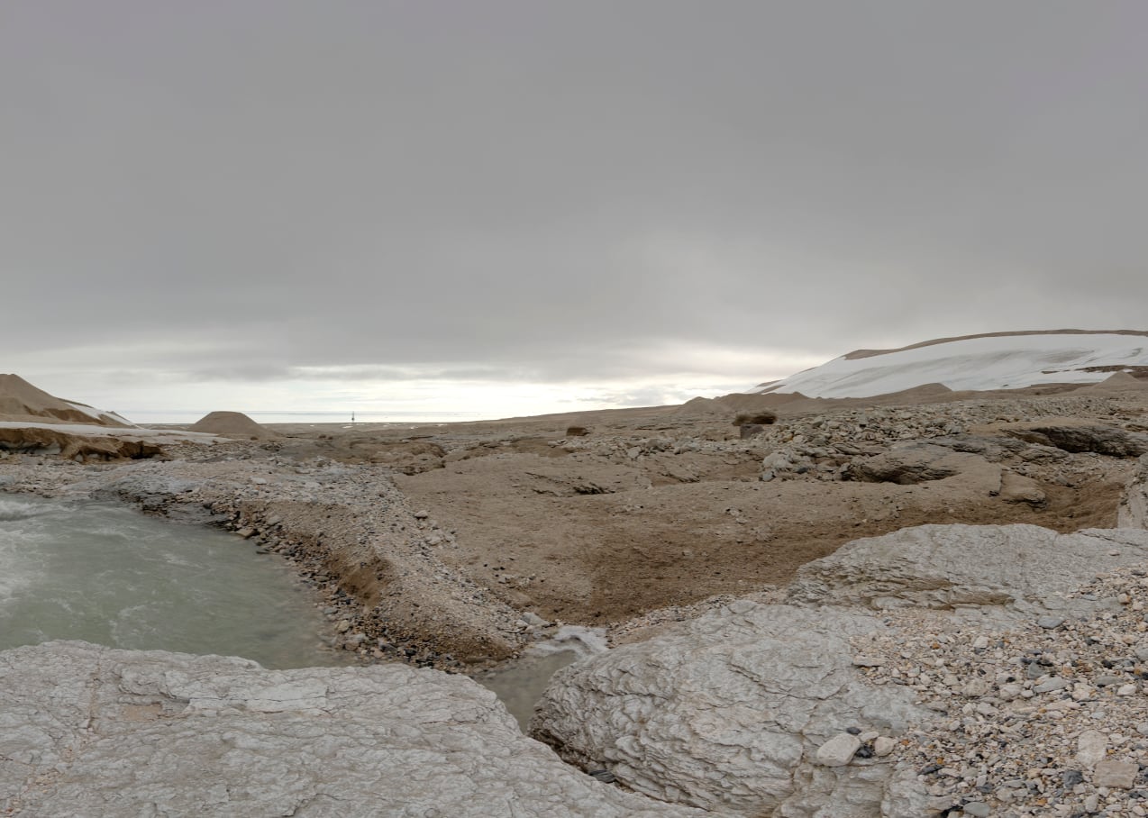
Meltwater river near the glacier.
The moraine-covered rim of the ice cap Austfonna is rising behind the river.
There is a geomorphologically very interesting area in the easternmost part of Vibehukta. Close to the ice cap, there is a meltwater river flowing through a little valley to the sea. Towards the glacier rim, the scenery is dominated by the bizarre moraine hills. The river itself has cut its bed well into the solid bedrock. This may have happened at times when the area was still glacier covered: subglacial (under the glacier) rivers may be under pressure and thus achieve great velocity and hence greater erosive forces.
- pano anchor link: #a5k_Vibebukta_25Juli14_147HDR
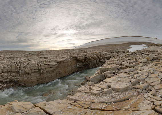
Meltwater river in Vibebukta.
Such subglacial meltwater channels may be filled up with gravel and sand at the end of their active time. When the glacier has disappeared, these channel fillings may stand out above the surroundings as long, narrow ridges of soft sediment. Such glacial landforms are known to geomorphologists as esker. Sweden is a classical country for eskers, which were hard to explain for early geologists before the ice age theory became a widely accepted concept. There are smaller examples of eskers also in Vibebukta, in this little valley near the glacier.
But also the river bed, which is cut into the bedrock, exhibits an interesting bit of landscape.
- pano anchor link: #180721b_Vibebukta_21HDR

Rocky river bed near the moraine-covered glacier edge of Austfonna.
- pano anchor link: #180721b_Vibebukta_40HDR
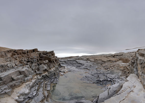
Abandoned river bed.
Photo gallery Vibebukta
And finally some impressions from Vibebukta, from small fossils to the huge landscape.
- gallery anchor link: #gallery_2112
Click on thumbnail to open an enlarged version of the specific photo.


BOOKS, CALENDAR, POSTCARDS AND MORE
This and other publishing products of the Spitsbergen publishing house in the Spitsbergen-Shop.
-

Norwegens arktischer Norden (1): Spitzbergen
Photobook: Norway's arctic islands. The text in this book is German. [shop url="https://shop.spitzbergen.de/en/polar-books/70-norwegens-arktischer-norden-1-aerial-arctic-9783937903262.html"] ← BackOrder now -
Norwegens arktischer Norden (2): Aerial Arctic
Lofoten, Jan Mayen and Spitsbergen from the air - Photobook: Norway's arctic islands. The text in this book is German, but there is very little text, so I am sure that you will enjoy it regardless which languages you read (or not).Order now -
Poster “Svalbardhytter”
The poster "Svalbardhytter" (70 x 100 cm) visualizes the diversity of Spitsbergen's huts in a range of arctic landscapes.Order now -
Book “Svalbardhytter”
The companion book for the Svalbardhytter poster. The poster visualises the diversity of Spitsbergen‘s huts and their stories in a range of Arctic landscapes. The book tells the stories of the huts in three languages.Order now -
Spitsbergen – Svalbard. The complete guidebook
Comprehensive guidebook about Spitsbergen. Background (wildlife, plants, geology, history etc.), practical information including travelling seasons, how to travel, description of settlements, routes and regions.Order now -
Rocks and Ice. Landscapes of the North
A geographical traveling accompaniment to Spitsbergen and East Greenland (68-74°N). This is the English edition of the German book "Steine und Eis".Order now -
East Greenland in Winter
Join an exciting journey with dog, skis and tent through the wintery wastes of East Greenland! We were five guys and a dog when we started in Ittoqqortoormiit, the northernmost one of two settlements on Greenland’s east coast.Order now -
Postcard set Spitsbergen (Svalbard)
12 Spitsbergen postcards in a beautifully designed tray. Individually numbered limited edition!Order now -
Limited edition postcard set Antarctica
12 postcards which come in a beautifully designed tray. Beautiful images from South Georgia across Antarctica from the Antarctic Peninsula to the Ross Sea and up to Macquarie Island and Campbell Island.Order now
last modification: 2025-03-25 ·
copyright: Rolf Stange


-
Books, Calendar, Postcards and more

-


