


-
current
recommendations- Liefdefjord
New page dedicated to one of Spitsbergen's most beautiful fjords. Background information and many photos.

- New Spitsbergen guidebook
The new edition of my Spitsbergen guidebook is out and available now!
- Liefdefjord
New page dedicated to one of Spitsbergen's most beautiful fjords. Background information and many photos.
-
weather information

| Guidebook: Spitsbergen-Svalbard |
Tokrossøya: portrait of an island near Spitsbergen's south cape
360 degree panoramic images, photos and background
Tokrossøya (“Two-cross-island”) is a small, almost tiny, island at the southern tip of Spitsbergen, near the south cape. Unknown to most and seemingly unimpressive at least at a quick and superficial glance or from the distance, Tokrossøya is situated between the main island of Spitsbergen and a couple of small islands, the largest of which is Sørkappøya, and many rocks and dangerous shallows.

The island is hardly more than one kilometre long and less than 400 metres wide, the highest “mountain” does not rise beyond 13 metres.
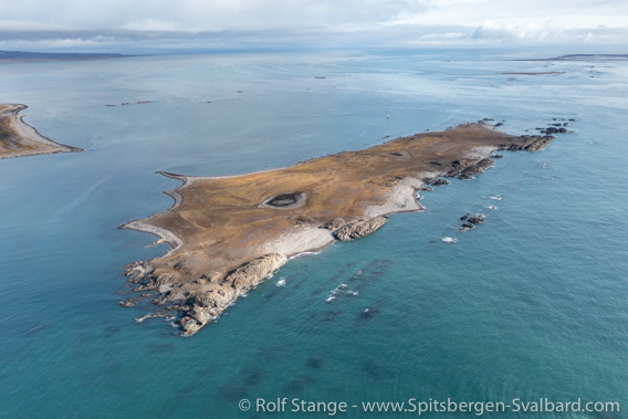
Tokrossøya from a bird’s eye’s view, looking from north to south.
Sørkappøya in the distance, upper right corner.
So … a boring, unimpressive island?
Tokrossøya: part of a conspicuous geological structure

Rocky hill at the north end of Tokrossøya.
Not at all. Admittedly, part of the fun lies in getting to remote places which almost nobody ever gets to see, let alone to set foot on. At least for me. But beyond this, the landscape on and round Tokrossøya is quite characteristic and those with a sense for landscape structure and details will find a lot to marvel at here. Just as the surrounding islands, Tokrossøya is part of a conspicuous belt, a characteristic geological structure that is responsible for a lot of eye-catching landscape features in many places. This belt stretches from north to south along a large proportion of Spitsbergen’s west coast, from the north side of Isfjord to the islands south of Tokrossøya. This belt consists of hard sedimentary layers which were tilted upwards into a north-south-trending, steeply dipping position by tectonic movements. The combination of these rocks being hard (geologically, not a very precise term, but anyway) and their vertical position has created geomorphological features including mountain ridges (for example, Värmlandryggen between Trygghamna and Ymerbukta), striking mountains (e.g. Ingeborgfjellet, Midterhukfjellet, Berzeliustinden), islands (Akseløya, Eholmen, Tokrossøya, Sørkappøya) and capes (Selmaneset and Kapp Starostin in Isfjord, Forsbladodden and Richardodden in Van Keulenfjord, Øyrlandsodden near Spitsbergen’s south cape). All these places are beautiful and interesting landscape features, each and every one of them in their own way, but all of them essentially cleary shaped by the geological structure of the hard layers.
- pano anchor link: #210821a_Tokrossoya_142HDR
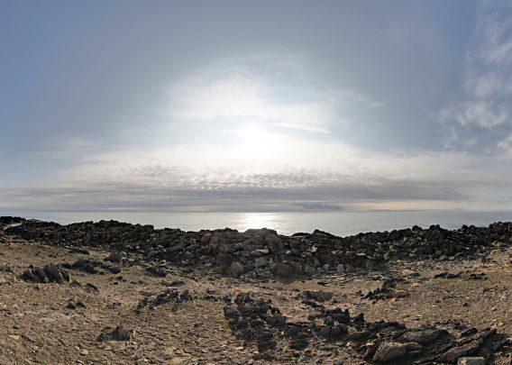
Panorama 1: rugged rocky hills on the west side of Tokrossøya
A hint of the Palaeozoic
The sediment layers in question are carbonates and date into the upper Carboniferous and lower Permian, which makes them around 300 million years old. In many places, you can find a lot of fossils such as brachiopods or corals in these rocks.
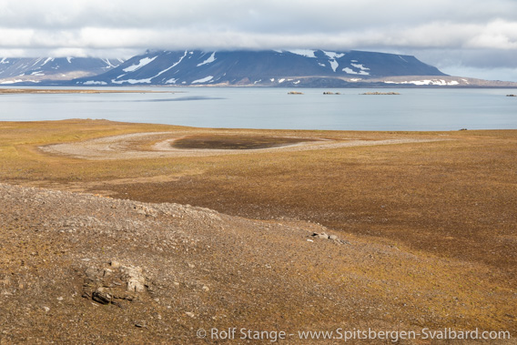
Flat tundra on the east side of Tokrossøya.
Just as Akseløya, Tokrossøya – which is much smaller – has a very characteristic composition: there are rugged, rocky hills along the western side and low-lying, flat tundra with comparatively significant vegetation on the east side, which covers the larger part of the island.
- pano anchor link: #210821a_Tokrossoya_163HDR
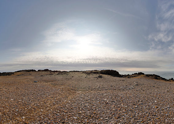
Panorama 2: flat tundra on the east side of Tokrossøya
The Pomors
Tokrossøya has got her name from two orthodox crosses which were set up by Pomor hunters on the northernmost hill of the island, which is also the highest one (13 m). The foundation of at least one of these crosses is still visible (there is a photo in the gallery down below), and so are the remains of an old grave on the same hill. But what catches the eye also from a distance are the two prominent cairns. It is now known when and by whom they were built.
Unfortunately, I don’t have a panorama image from this hill at the north tip of the island. I had already set up the tripod and was ready to go, when I realised that the camera bag where I expected to find the camera that I needed for this purpose had another one, still from the day before – different hardware for different occasions, but not enough bags 🙂 skipper Heinrich and my colleague Helga who were with me on Arctica II in August 2021, when we were lucky enough to make this visit to Tokrossoya, kindly made sure that I got the camera that I needed later, so I could at least shoot two panoramas near the south end of the island. It would have been a shame to miss that opportunity, it absolutely not a place where you can just say “ok, next time.”
Inaccessible islands
There is a couple of reasons for this: first of all, there is the weather in this area, which has a bad reputation for good reason. But you need really good conditions to operate safely in these shallow and very exposed waters. And additionally, all these islands together are a bird sanctuary, which means you have to keep a distance of at least 300 metres from 15 May to 15 August. And this is for good reason: there are a lot of birds breeding there during the summer, including Common eiders, Purple sandpipers, Arctic terns and others, while others such as geese are resting there after the spring migration.
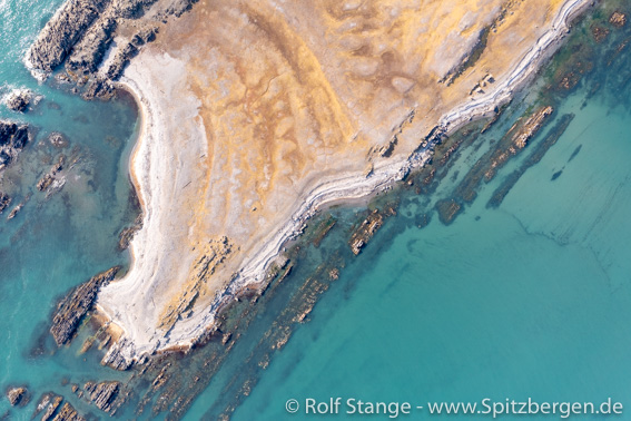
Rocky shores and many shallows near Tokrossøya from a bird’s eye’s perspective.
On top of this comes the rocky coastline and the many shallows which make the shore mostly inaccessible.
Most ships in the area will keep a good distance from these isands, and this is good unless you are sure that you know what you are doing and that you have got the right conditions for a visit. Only really small vessels can attempt to cut the passage around the islands short by taking a route between Tokrossøya and Sørkappøya, but local knowledge is essential. Today’s charts of these waters, including the seemingly detailed electronic one, are certainly not perfect (as of 2021).
Tokrossøya photo gallery
Finally, some impressions from Tokrossøya.
- gallery anchor link: #gallery_2079
Click on thumbnail to open an enlarged version of the specific photo.


BOOKS, CALENDAR, POSTCARDS AND MORE
This and other publishing products of the Spitsbergen publishing house in the Spitsbergen-Shop.
-

Norwegens arktischer Norden (1): Spitzbergen
Photobook: Norway's arctic islands. The text in this book is German. [shop url="https://shop.spitzbergen.de/en/polar-books/70-norwegens-arktischer-norden-1-aerial-arctic-9783937903262.html"] ← BackOrder now -
Norwegens arktischer Norden (2): Aerial Arctic
Lofoten, Jan Mayen and Spitsbergen from the air - Photobook: Norway's arctic islands. The text in this book is German, but there is very little text, so I am sure that you will enjoy it regardless which languages you read (or not).Order now -
Poster “Svalbardhytter”
The poster "Svalbardhytter" (70 x 100 cm) visualizes the diversity of Spitsbergen's huts in a range of arctic landscapes.Order now -
Book “Svalbardhytter”
The companion book for the Svalbardhytter poster. The poster visualises the diversity of Spitsbergen‘s huts and their stories in a range of Arctic landscapes. The book tells the stories of the huts in three languages.Order now -
Spitsbergen – Svalbard. The complete guidebook
Comprehensive guidebook about Spitsbergen. Background (wildlife, plants, geology, history etc.), practical information including travelling seasons, how to travel, description of settlements, routes and regions.Order now -
Rocks and Ice. Landscapes of the North
A geographical traveling accompaniment to Spitsbergen and East Greenland (68-74°N). This is the English edition of the German book "Steine und Eis".Order now -
East Greenland in Winter
Join an exciting journey with dog, skis and tent through the wintery wastes of East Greenland! We were five guys and a dog when we started in Ittoqqortoormiit, the northernmost one of two settlements on Greenland’s east coast.Order now -
Postcard set Spitsbergen (Svalbard)
12 Spitsbergen postcards in a beautifully designed tray. Individually numbered limited edition!Order now -
Limited edition postcard set Antarctica
12 postcards which come in a beautifully designed tray. Beautiful images from South Georgia across Antarctica from the Antarctic Peninsula to the Ross Sea and up to Macquarie Island and Campbell Island.Order now
last modification: 2025-03-25 ·
copyright: Rolf Stange


-
Books, Calendar, Postcards and more

-


