-
current
recommendations- Liefdefjord
New page dedicated to one of Spitsbergen's most beautiful fjords. Background information and many photos.
- New Spitsbergen guidebook
The new edition of my Spitsbergen guidebook is out and available now!
- Liefdefjord
New page dedicated to one of Spitsbergen's most beautiful fjords. Background information and many photos.
Page Structure
-
Spitsbergen-News
- Select Month
- June 2025
- May 2025
- April 2025
- March 2025
- February 2025
- January 2025
- December 2024
- November 2024
- October 2024
- September 2024
- August 2024
- July 2024
- June 2024
- May 2024
- April 2024
- March 2024
- February 2024
- January 2024
- December 2023
- November 2023
- October 2023
- September 2023
- August 2023
- July 2023
- June 2023
- May 2023
- April 2023
- March 2023
- February 2023
- January 2023
- December 2022
- November 2022
- October 2022
- September 2022
- August 2022
- July 2022
- June 2022
- May 2022
- April 2022
- March 2022
- February 2022
- January 2022
- December 2021
- November 2021
- October 2021
- September 2021
- August 2021
- July 2021
- June 2021
- May 2021
- April 2021
- March 2021
- February 2021
- January 2021
- December 2020
- November 2020
- October 2020
- September 2020
- August 2020
- July 2020
- June 2020
- May 2020
- April 2020
- March 2020
- February 2020
- January 2020
- December 2019
- November 2019
- October 2019
- September 2019
- August 2019
- July 2019
- June 2019
- May 2019
- April 2019
- March 2019
- February 2019
- January 2019
- December 2018
- November 2018
- October 2018
- September 2018
- August 2018
- July 2018
- June 2018
- May 2018
- April 2018
- March 2018
- February 2018
- January 2018
- December 2017
- November 2017
- October 2017
- September 2017
- August 2017
- July 2017
- June 2017
- May 2017
- April 2017
- March 2017
- February 2017
- January 2017
- December 2016
- November 2016
- October 2016
- September 2016
- August 2016
- July 2016
- June 2016
- May 2016
- April 2016
- March 2016
- February 2016
- January 2016
- December 2015
- November 2015
- October 2015
- September 2015
- August 2015
- July 2015
- June 2015
- May 2015
- April 2015
- March 2015
- February 2015
- January 2015
- December 2014
- November 2014
- October 2014
- September 2014
- August 2014
- July 2014
- June 2014
- May 2014
- April 2014
- March 2014
- February 2014
- January 2014
- December 2013
- November 2013
- October 2013
- September 2013
- August 2013
- July 2013
- June 2013
- May 2013
- April 2013
- March 2013
- February 2013
- January 2013
- December 2012
- November 2012
- October 2012
- September 2012
- August 2012
- July 2012
- June 2012
- May 2012
- April 2012
- March 2012
- February 2012
- January 2012
- December 2011
- November 2011
- October 2011
- September 2011
- August 2011
- May 2011
- April 2011
- March 2011
- February 2011
- January 2011
- December 2010
- November 2010
- September 2010
- August 2010
- July 2010
- June 2010
- May 2010
- April 2010
- March 2010
- February 2010
- November 2009
- October 2009
- August 2009
- July 2009
- June 2009
- May 2009
- April 2009
- March 2009
- February 2009
- January 2009
- December 2008
- November 2008
- October 2008
- August 2008
- July 2008
- June 2008
- May 2008
- April 2008
- March 2008
- February 2008
- April 2000
- Select Month
-
weather information
-
Newsletter

| Guidebook: Spitsbergen-Svalbard |
Hornsund

P = Polish Station (Isbjørnhamna), Ha = Hansbreen, Bu = Burgerbukta, Tr = Treskelen, Br = Brepollen, B = Bautaen, S = Samarinvågen, H = Hornsundtind, H = Gåshamna
General: The most beautiful fjord in Spitsbergen (as Bellsund, Isfjord, St. Jonsfjord, Kongsfjord, Smeerenburgfjord, Liefdefjord etc. ) and definitely the southernmost one. Great scenery! The Hornsund cuts approximately 25 kilometres deep into the island.
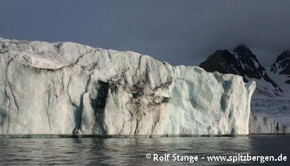
One of many calving glacier fronts in the Hornsund.
Because of the topography, there are relatively few landing sites, but just cruising through the Hornsund can be amazing – provided the weather doesn’t screw things up. The Polish station is the only research station outside the settlements; it is remarkable, that Poland has kept its station, whilst other countries have abandoned theirs – Sweden with Kinnvika on Nordaustland, The Netherlands with Kapp Lee on Edgeøya. There is not an awful lot of tundra, but at some spots, the vegetation can be very rich and colourful. This is partly due to fertilization by very large Little auk colonies. There is a number of interesting cultural monuments.
Seemingly paradox, there is more drift ice in the Hornsund than further north at the west coast. This is due to a cold current which comes from the northeast on the eastern side of Svalbard and then around the south cape and up the west coast. It brings a lot of ice to the southern part of the west coast, so the Hornsund is usually blocked with ice in the early summer, even if the other fjords further north are already ice-free. It also brings a lot of cold, polar watermasses into the Hornsund, which stays in the inner part of the fjord, thus providing a high-polar marine ecosystem in direct neighbourhood to the more subarctic waters influenced by the gulf stream. This provides for an interesting faunal cross-section from subarctic to high arctic within a small area (nothing people like you and me would ever get to see. But people like Rupert, if you know him, put some small, slimy things under the microscope and can tell you an amazing lot about it).
The Hornsund area is part of the South Spitsbergen National Park.
Geology: Varied. The Hornsund offers a relatively representative cross section through the geology of Svalbard, similar to the Bellsund. In comparison, the stratigraphy is more complete in the Hornsund, as the Devonian Old Red is present here, and the basement is cropping out in a larger area, from the west coast into central parts of the fjord. The Hornsundtind consists of crystalline basement carbonates (upper Proterozoic). Otherwise, the basement in the Hornsund area is dominated by weakly to medium metamorphosed sediments (additionally to various carbonates, there are schists, phyllites, quarzites etc.). Magmatic rocks play only a very subordinate role, as opposed to the basement in northern Svalbard.
The sedimentary cover rocks start on the eastern side of Burgerbukta and Samarinvågen. On the northern side, it starts with Devonian conglomerates and sandstones (‘Old Red’), followed by the prominent Kapp Starostin Formation with its hard, fossil-rich limestones. They are dipping vertically, similar to the situation in the Bellsund, forming conspicuous peninsula (Treskelen) and mountains. Bautaen is quite spectacular: grinded down by glacial erosion from both sides, it looks as a needle, if you look from the right perspective, and is thus almost as striking as the Hornsundtind with its 1431 m, despite its lower height.

Bautaen.
A very nice section can be seen on the eastern side of Burgerbukta, where the lower slopes expose Devonian Old Red, overlain by dark Triassic sediments and finally topped by the yellowish-brown Permian carbonates, to which the Kapp Starostin Formation belongs – and, to make this all even better, nicely folded as an anticline (large fold, central part is bent up or ‘against’ (‘anti’) the sky).

Hyrnefjellet east of Burgerbukta with nice anticline (which means that the layers are bent upwards). The lowermost layer (just below image centre) Devonian Old Red, then light-brown Carboniferous and mainly Permian carbonates finally followed by dark Mesozoic sediments.
Similarly to the situation further north in the Bellsund, the deformation of the rocks is striking.
Tectonic activity during the opening of the north Atlantic took place west of the west coast (well, makes sense, as that’s where the Atlantic is). The nearer to the coast, the stronger are uplift and deformation of the rocks. Close to the coast, uplift was strong enough to expose the basement, which is buried under several kilometres of sedimentary cover in central Spitsbergen. Close to the basement, the sedimentary cover rocks are strongly deformed and dip vertically with a N-S trend and expose nice folds and faults (east of Burgerbukta, Treskelen, Bautaen). Further to the east, where the sediments have preserved their original, horizontal position, you find the classical plateau-shaped mountains; this is the case east of Brepollen, the innermost part of the Hornsund.
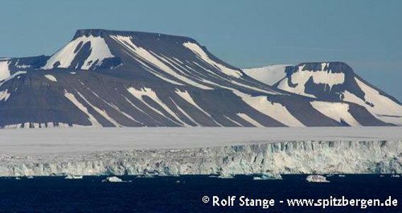
Plateau-shaped mountains composed of nearly horizontal sediment layers east of the Hornsund.
Recommended book for further, well-digestable (really!) info about geology and landscape of Svalbard.
Landscape: Spectacular. The outer coast north and south of Hornsund features large coastal plains. The first mountain chain is relatively ice-free, there are some larger, partly ice-free valleys such as Gåshamna, where you can find very nice frost-patterned ground.
The central and inner parts of the Hornsund are strongly glaciated, so there are almost no tundra areas there. There are almost vertical rockwalls and wild mountains around Burgerbukta and Samarinvågen. West of Samarinvågen, the mighty Hornsundtind is towering over the fjord with its 1431 metres, but you need quite a bit of luck with the weather to see it form tip to toe. There are glaciers calving into all side bays, so there is often a lot of ice on the water; icebergs, growlers and bergy bits, as the whalers used to call small pieces of ice.

The Hornsundtind.
Brepollen, the innermost part of the Hornsund, is almost completely surrounded with glaciers. Because of the general, well-known retreat of glaciers also in Spitsbergen, which is very pronounced in the Brepollen, there are more and more moraines visible at the coast, to a larger degree than indicated on the scetch map above.
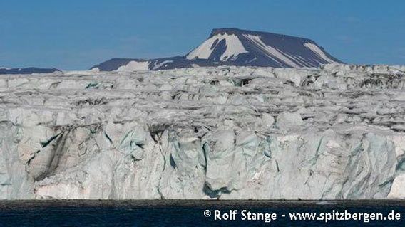
Calving glacier front in Brepollen (innermost Hornsund).
Flora and Fauna: Because of the topography, there are few tundra areas, but the vegetation can be very colourful near bird colonies. Here, you can find reindeer, fox, geese etc. The Hornsund is well-known for its large colonies of Little auks (Alle alle), there are hundreds of thousands of them breeding in the Hornsund; most of Svalbard’s Little auks breed either here or in the northwest of Spitsbergen. Little auks breed under large bolders, which means that you can’t see the nest itself. The breeding sites are ususally inaccessible due to the steep and rocky terrain, and in other locations such as near the Polish station, there are sometimes research projects going on, which means these sites can be off limits for tourists.
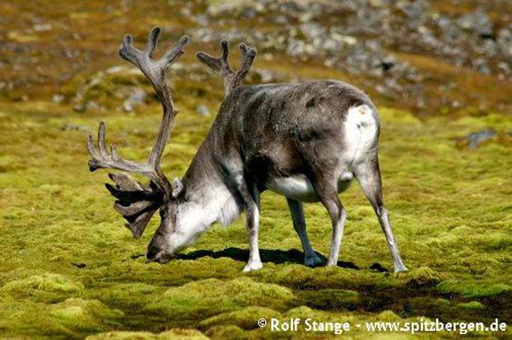
Reindeer enjoying rich vegetation under a colony of Little Auks in the Hornsund.
Because of the currents, which bring drift ice from the east and around the south cape of Spitsbergen into the Hornsund, this fjord is an important migration area for polar bears. Even though this is mostly true for the winter season, you have to be very careful in the area also in the summer – there is alway a bear somewhere in the Hornsund, possibly behind the big boulder, directly behind you…
History: Long and quite interesting. Similar to the Bellsund, it was amongst the first fjords which was discovered by whalers in the 17th century. The Hornsund got its name from Jonas Poole, an English whaler, after some of his men had found a piece of reindeer antler there. It is possible that Poole believed that the Hornsund was actually a strait through which it was possible to sail to the east coast of Spitsbergen, so he called it ‘Horne Sound’ and not ‘Horne Bay’ or similar. There are remains of blubber ovns and graves visible at several locations. Also the Pomors have used the Hornsund for hunting purposes.
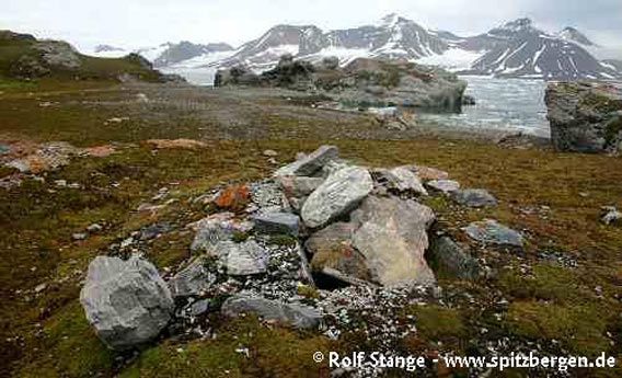
Whaler’s grave in the Hornsund.
Amongst the expeditions which have visited the Hornsund, for example the one of the Austrian-Hungarian Count Hans Wilczek in 1872 can be mentioned. Wilczek was an important sponsor of polar expeditions such as the ‘Tegethoff’ expedition with Karl Weyprecht and Julius Payer, during which Franz Josef Land was discovered. The bay Isbjørnhamna on the northern side of the Hornsund is named after Wilczek’s ship, the ‘Isbjørn’, which Wilczek used to accompany the ‘Tegethoff’ for a while in the Barents Sea. After they had separated near Novaya Zemlya, Wilczek sailed further to Spitsbergen and visited the Hornsund. Also Wilczekodden on the west side of Isbjørnhamna is named after him, as is Hansbreen further to the east.
The Swedish-Russian Arc-de-Meridian expedition (1899-1904) had one of its main quarters in Gåshamna.
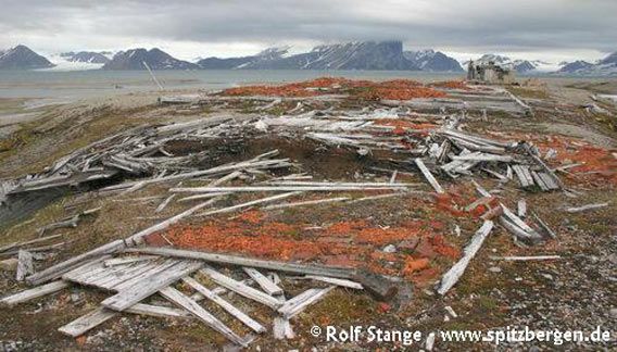
Remains of the station of the Arc-de-Meridian expedition in Gåshamna.
Poland established a station in Isbjørnhamna during the International Polar Year 1957-58. The station was kept beyond the polar year and, after a while, it was staffed year-round, so since the early seventies, there are constantly scientists in the Hornsund. During the winter, the crew is reduced to a core team, whereas in the summer there are often guest scientists from different nations. During the years of the iron curtain, the station in the Hornsund was a very valuable platform for polish scientists also to get in touch with western colleagues. Amongst the most important tasks of any polar station are long-term standard measurements within meteorology, Earth magnetism, seismology, northern lights etc. Additionally, there are different projects within certain, limited timeframes. Whereas the focus used to be on geomorphology and geology for a long time, nowadays glaciology has become very important; glacier studies, among others to understand the relationship between glaciers and climate change. The nearby Little auk colony makes zoology and arctic ecology an obvious field of study, and so do the interesting oceanographic mosaic of the Hornsund (see ‘general’ section).

Polish research station in the Hornsund.
The first successful ascent of the Hornsundtind was achieved by the German climbing expedition of Dr. Rieche in 1938. The Hornsundtind is technically much more demanding than the two highest mountains of Spitsbergen, Newtontoppen and Perriertoppen, in the northeast.
BOOKS, CALENDAR, POSTCARDS AND MORE
This and other publishing products of the Spitsbergen publishing house in the Spitsbergen-Shop.
last modification: 2013-10-11 ·
copyright: Rolf Stange


