-
current
recommendations- Liefdefjord
New page dedicated to one of Spitsbergen's most beautiful fjords. Background information and many photos.

- New Spitsbergen guidebook
The new edition of my Spitsbergen guidebook is out and available now!

- Liefdefjord
New page dedicated to one of Spitsbergen's most beautiful fjords. Background information and many photos.
Page Structure
-
Spitsbergen-News
- Select Month
- June 2025
- May 2025
- April 2025
- March 2025
- February 2025
- January 2025
- December 2024
- November 2024
- October 2024
- September 2024
- August 2024
- July 2024
- June 2024
- May 2024
- April 2024
- March 2024
- February 2024
- January 2024
- December 2023
- November 2023
- October 2023
- September 2023
- August 2023
- July 2023
- June 2023
- May 2023
- April 2023
- March 2023
- February 2023
- January 2023
- December 2022
- November 2022
- October 2022
- September 2022
- August 2022
- July 2022
- June 2022
- May 2022
- April 2022
- March 2022
- February 2022
- January 2022
- December 2021
- November 2021
- October 2021
- September 2021
- August 2021
- July 2021
- June 2021
- May 2021
- April 2021
- March 2021
- February 2021
- January 2021
- December 2020
- November 2020
- October 2020
- September 2020
- August 2020
- July 2020
- June 2020
- May 2020
- April 2020
- March 2020
- February 2020
- January 2020
- December 2019
- November 2019
- October 2019
- September 2019
- August 2019
- July 2019
- June 2019
- May 2019
- April 2019
- March 2019
- February 2019
- January 2019
- December 2018
- November 2018
- October 2018
- September 2018
- August 2018
- July 2018
- June 2018
- May 2018
- April 2018
- March 2018
- February 2018
- January 2018
- December 2017
- November 2017
- October 2017
- September 2017
- August 2017
- July 2017
- June 2017
- May 2017
- April 2017
- March 2017
- February 2017
- January 2017
- December 2016
- November 2016
- October 2016
- September 2016
- August 2016
- July 2016
- June 2016
- May 2016
- April 2016
- March 2016
- February 2016
- January 2016
- December 2015
- November 2015
- October 2015
- September 2015
- August 2015
- July 2015
- June 2015
- May 2015
- April 2015
- March 2015
- February 2015
- January 2015
- December 2014
- November 2014
- October 2014
- September 2014
- August 2014
- July 2014
- June 2014
- May 2014
- April 2014
- March 2014
- February 2014
- January 2014
- December 2013
- November 2013
- October 2013
- September 2013
- August 2013
- July 2013
- June 2013
- May 2013
- April 2013
- March 2013
- February 2013
- January 2013
- December 2012
- November 2012
- October 2012
- September 2012
- August 2012
- July 2012
- June 2012
- May 2012
- April 2012
- March 2012
- February 2012
- January 2012
- December 2011
- November 2011
- October 2011
- September 2011
- August 2011
- May 2011
- April 2011
- March 2011
- February 2011
- January 2011
- December 2010
- November 2010
- September 2010
- August 2010
- July 2010
- June 2010
- May 2010
- April 2010
- March 2010
- February 2010
- November 2009
- October 2009
- August 2009
- July 2009
- June 2009
- May 2009
- April 2009
- March 2009
- February 2009
- January 2009
- December 2008
- November 2008
- October 2008
- August 2008
- July 2008
- June 2008
- May 2008
- April 2008
- March 2008
- February 2008
- April 2000
- Select Month
-
weather information
-
Newsletter

| Guidebook: Spitsbergen-Svalbard |
Home
→ Spitsbergen books: Books, Calendar, Postcards, DVDs
→ Rocks and Ice
→ Geology of East Greenland
→ 4. The Jameson Land basin
4. The Jameson Land basin
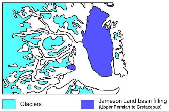
Finally, the graben systems of the Old Red and New Red area had stopped subsiding, and it was quite calm for a while. But soon, other, large areas began to subside slowly. This time, subsidence occured not along distinct fault lines, but more as a wide-spanned bending of the crust, so the result is called a ‘basin’ rather than a ‘graben’. The sediments deposited in these basins can be found in the whole of Jameson Land as well as in southeastern Milne Land.
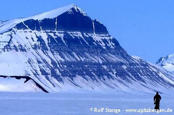
Sediment layers (upper Triassic-lower Jurassic) of the Jameson Land basin filling.
Macknight Bjerg (northern Jameson Land, Western side of Carlsberg Fjord)
Soon, shallow sea started to fill these basins. This sea was not extremely deep, a few hundred metres maximum or even less, so the coastline was not far away. They even fell completely dry at times. Basin formation started in the youngest part of the Palaeozoic, the upper Permian, a bit more than 250 million years ago. As a start, wide, low-lying plains formed with desert-like landscapes, where occasional floods left sand and gravel. First ingressions of the sea left limestone and, due to subsequent evaporation of seawater which was not replaced, gypsym. There are also some dark, fine-grained marine sediments. The dark colour is due to a high content of organic matter, which drew the attention of the oil- and gas industry to the respective areas in Liverpool Land and Milne Land, but spectacular finds have not been published.
During further development, the sea advanced and retreated once again, leaving marine siltstone (as sandstone, but with somewhat finer grains) covered by dune sands and deposits of salt lakes, including layers of gypsym.
Finally, the sea advanced again and stayed for a long time. From now on, a quite narrow but long basin in East Greenland, stretching from the Scoresbysund area or even a bit further south far to the north, remained filled with seawater for more than 100 million years.
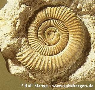
Typical sediments were deposited in these relatively shallow seas, mostly sandstone and claystone (as sandstone deposited as single grains, which later stuck together and thus formed a hard rock mass, but with invisibly small sediment grains). Also the inhabitants of those seas left their traces. At some locations, we can find large amounts of fossils such as ammonites, shells etc. Especially the ammonites are so abundant in some layers and so well preserved, that changes in their physiology during the course of evolution are visible. This enables geologists to establish a detailed chronology of geological events and the history of life in the area. The resolution in time is almost razor-blade sharp, at least in geological terms: a single stratigraphic unit often cover just one million years! The ammonite zone is 150-200 million years old (Jurassic).
Ammonite (Jurassic)
Uplift and subsidence of different parts of the basin led to changes of water depths. When the sea became very shallow, the coast came near and coastal sediments were deposited: sandy beach deposits, but delta sediments were often dominant: large volumes of sand deposited by rivers at the coast. These deltas were sometimes quite rich in vegetation, as is the Mississippi Delta today. Sometimes, the vegetation got buried under a new layer of sand. Then, it could subsequently be turned into coal after a long time. There are indeed several coal seams in Jameson Land and at other places further north, but of inferiour quality and quantity. It has been used locally, though, for example at Kap Hope near Ittoqqortoormiit (Scoresbysund), where a small area of sediments has survived erosion at the southwestern corner of Liverpool Land.
The deposition of sediments in the basin lasted throughout most of the Mesozoic into the lower Cretaceous, about 100 million years ago. It probably lasted even longer, at least into the upper Cretaceous (up to 65 million years ago) or even beyond that. In the Scoresbysund, all sediments younger than lower Cretaceous, should they have existed, have been removed again by erosion. There are some very small areas of Tertiary sediments south of the Scoresbysund, at Kap Brewster and Kap Dalton at the outer coast.
Finally, basin subsidence ended, and so did subsequently this chapter of Earth history in East Greenland.
The sediments which slowly filled the basin can now be found everywhere in Jameson Land and at the southeastern corner of Milne Land. The horizontal layering is mostly very obvious, for example when you arrive at the little airport of Constable Point. Some of the harder layers have been dissected by erosion in such a way that they form very nice, regular towers, which can remind one of a fortress or a Gothic church.
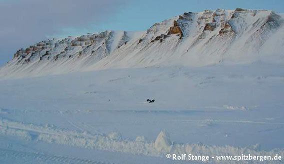
Sedimentary layers of the Jameson Land basin fill (here lower Jurassic) at Constable Point. The regular towers were created by erosion.
The basin sediments are mostly comparatively soft, at least compared to the gneisses and granites of the Precambrian Shield and the Caledonian fold belt. Accordingly, there are no high, pointed mountains, but rather open, relatively low hills which are often topped by markant plateaus, following the horizontal layers.
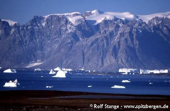
Contrast between flat tundra in western Jameson Land and mountaineous Milne Land in the background.
BOOKS, CALENDAR, POSTCARDS AND MORE
This and other publishing products of the Spitsbergen publishing house in the Spitsbergen-Shop.
last modification: 2013-10-12 ·
copyright: Rolf Stange
