


-
current
recommendations- Liefdefjord
New page dedicated to one of Spitsbergen's most beautiful fjords. Background information and many photos.

- New Spitsbergen guidebook
The new edition of my Spitsbergen guidebook is out and available now!
- Liefdefjord
New page dedicated to one of Spitsbergen's most beautiful fjords. Background information and many photos.
-
weather information

| Guidebook: Spitsbergen-Svalbard |
Krossfjord: Collinsodden
Coastal plain and northern light research: panorama images and background
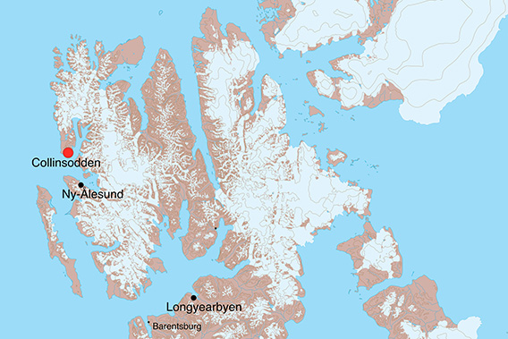
Collinsodden is located at the entrance to Krossfjord, not far from Kapp Mitra.
Collinsodden Panorama 1: coastal landscape
- pano anchor link: #170731a_Collinsodden_175HDR
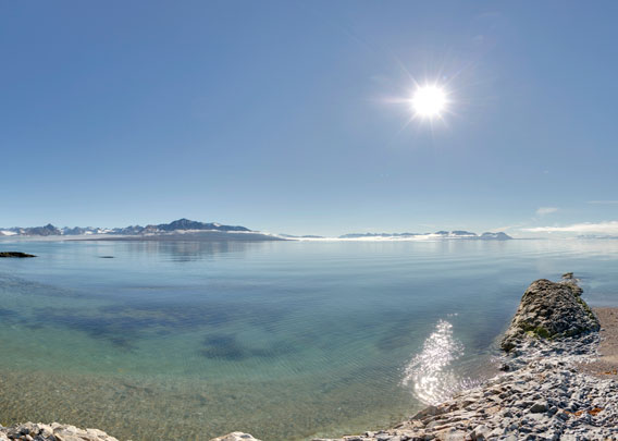
Collinsodden is situated at the entry of Krossfjord. It is not exactly well sheltered, to put it mildly, but on a lovely day like this, the coastline with some wide beaches, interrupted by small, rocky points, can almost appear tropical 🙂
Collinsodden Panorama 2: the coastal plain
- pano anchor link: #170731a_Collinsodden_124HDR
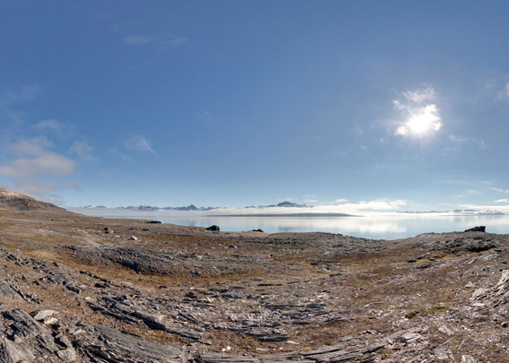
The flat coastal plain stretches over many kilometres, from Ebeltofthamna in Krossfjord and up the west coast (Diesetsletta). It was probably created by wave action during the pleistocene, which cut a coastal platform into the bedrock (schist, in this case).
Collinsodden Panorama 3: the old hut
- pano anchor link: #170731a_Collinsodden_086HDR
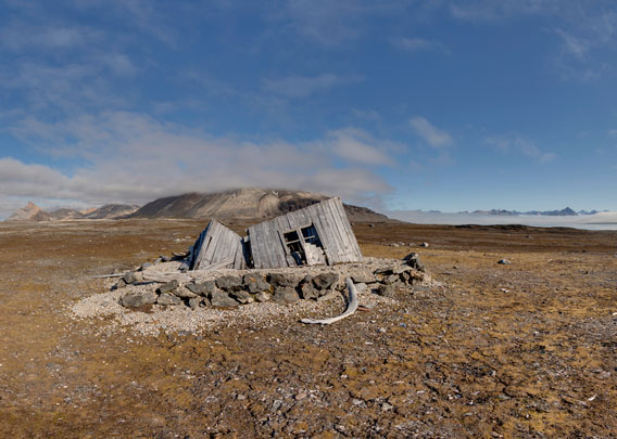
There is a ruin of an old hut a bit away from the coast. It was a trapper hut, but it was used for scientific purposes for a short period between 1912 and 1914. In those years, there was a German meteorological observatory a good 7 kilometres away in Ebeltofthamna, initiated after Count Zeppelin’s expedition in 1910 and led by Kurt Wegener, brother of the famous Alfred Wegener (the one with the plate tectonics). Next to meteorology, the scientists also did some work on the northern lights.
Meteorologist Max Robitzsch took the initiative to photograph the aurora from simultaneously from two positions a couple of kilometres apart for altitude determination. Next to the main base in Ebeltofthamna, this old hut at Collinsodden was chosen as a secondary base for northern light photography during the dark season. To enable perfect synchronisation, they even improvised a telephone connection over more than 7 kilometres between the two sites!
- pano anchor link: #170731a_Collinsodden_105HDR
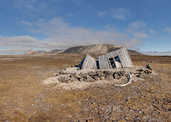
Photo gallery Krossfjord: Collinsodden
The landscape and the old hut at Collinsodden on a wonderful summer day.
- gallery anchor link: #gallery_3581
Click on thumbnail to open an enlarged version of the specific photo.


BOOKS, CALENDAR, POSTCARDS AND MORE
This and other publishing products of the Spitsbergen publishing house in the Spitsbergen-Shop.
-

Norwegens arktischer Norden (1): Spitzbergen
Photobook: Norway's arctic islands. The text in this book is German. [shop url="https://shop.spitzbergen.de/en/polar-books/70-norwegens-arktischer-norden-1-aerial-arctic-9783937903262.html"] ← BackOrder now -
Norwegens arktischer Norden (2): Aerial Arctic
Lofoten, Jan Mayen and Spitsbergen from the air - Photobook: Norway's arctic islands. The text in this book is German, but there is very little text, so I am sure that you will enjoy it regardless which languages you read (or not).Order now -
Poster “Svalbardhytter”
The poster "Svalbardhytter" (70 x 100 cm) visualizes the diversity of Spitsbergen's huts in a range of arctic landscapes.Order now -
Book “Svalbardhytter”
The companion book for the Svalbardhytter poster. The poster visualises the diversity of Spitsbergen‘s huts and their stories in a range of Arctic landscapes. The book tells the stories of the huts in three languages.Order now -
Spitsbergen – Svalbard. The complete guidebook
Comprehensive guidebook about Spitsbergen. Background (wildlife, plants, geology, history etc.), practical information including travelling seasons, how to travel, description of settlements, routes and regions.Order now -
Rocks and Ice. Landscapes of the North
A geographical traveling accompaniment to Spitsbergen and East Greenland (68-74°N). This is the English edition of the German book "Steine und Eis".Order now -
East Greenland in Winter
Join an exciting journey with dog, skis and tent through the wintery wastes of East Greenland! We were five guys and a dog when we started in Ittoqqortoormiit, the northernmost one of two settlements on Greenland’s east coast.Order now -
Postcard set Spitsbergen (Svalbard)
12 Spitsbergen postcards in a beautifully designed tray. Individually numbered limited edition!Order now -
Limited edition postcard set Antarctica
12 postcards which come in a beautifully designed tray. Beautiful images from South Georgia across Antarctica from the Antarctic Peninsula to the Ross Sea and up to Macquarie Island and Campbell Island.Order now
last modification: 2025-04-01 ·
copyright: Rolf Stange


-
Books, Calendar, Postcards and more

-


