


-
current
recommendations- Liefdefjord
New page dedicated to one of Spitsbergen's most beautiful fjords. Background information and many photos.

- New Spitsbergen guidebook
The new edition of my Spitsbergen guidebook is out and available now!
- Liefdefjord
New page dedicated to one of Spitsbergen's most beautiful fjords. Background information and many photos.
-
weather information

| Guidebook: Spitsbergen-Svalbard |
Home
→ * Photos, Panoramas, Videos and Webcams
→ Spitsbergen Panoramas
→ Hiorthfjellgruva: Ørneredet
Hiorthfjellgruva: Ørneredet
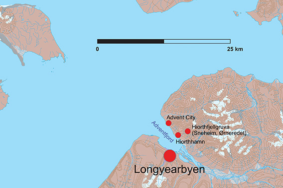
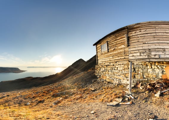
“Ørneredet” is located 580 metres high on Hiorthfjellet.
Ørneredet, ‘the eagle’s nest’, was the miners’ mess and accommodation at Hiorthfjellgruve (Sneheim) high up on Hiorthfjellet, 582 metres above Adventfjord. In the past, the entire complex was officially called Hiorthfjellgruve (Hiorthfjellgrube), unofficially it was usually called Sneheim and today many refer to it as ‘Ørneredet’, i.e. ‘the eagle’s nest’. It fits quite well, even if the name has no real historical reference. And there are no eagles in Spitsbergen either, but who cares …
The actual settlement was Hiorthhamn down by the fjord. Hiorthhamn, Sneheim and Ørneredet (the division of the latter two into two villages is somewhat artificial and is more for the sake of clarity on these pages) thus formed a functional complex that belonged together. On the pages about Hiorthhamn and Sneheim you can also read more about the history of the whole Hiorthhamn mine complex, which will not be repeated here.
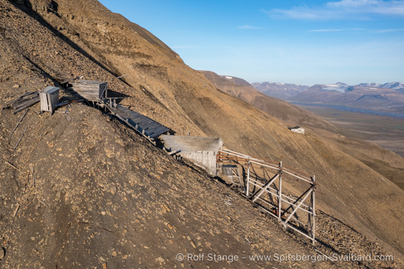
The Hiorthfjellgruve: in front are the remains of the actual mine workings,
the building at the back is the ‘Ørneredet’, the workers’ mess and accommodation.
Everything is located a good 580 metres above sea level at Hiorthfjellet.
The workers’ accommodation at the Hiorthfjellet mine
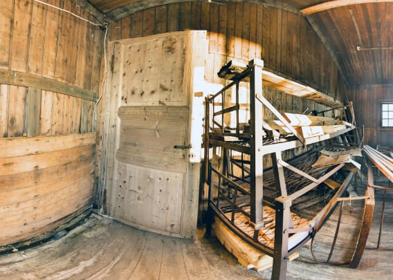
The location of the first panoramic photo is in the area where the workers’ accommodation was once located. Several dozen workers were housed here, sometimes staying for months at a time and not moving further away than the pit, a few hundred metres to the west.
There is practically nothing left of the accommodation, just rubble scattered around the site. There were once five barracks.
- pano anchor link: #a9p_Hiorthfjellet_23Aug14_603
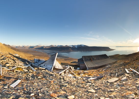
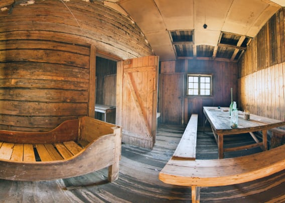
Mess room building
The only building still standing is the one with the mess rooms.
- pano anchor link: #a9p_Hiorthfjellet_23Aug14_622
It is hard to say why the mess room is the only building still standing, or why, in contrast, the other buildings have been completely lost. It was probably repaired from time to time, potentially including the years before 1992.
- pano anchor link: #a9p_Hiorthfjellet_23Aug14_641
In 1992, some simple but important repairs were carried out at the mess room building in order to preserve its substance – also with the help of the mining company’s heirs, who were still the landowners in 1992. In 2016, the area – 217.6 square kilometres – was sold to the Norwegian state for a whopping 300 million kroner. But that’s another story.
- pano anchor link: #a9p_Hiorthfjellet_23Aug14_660
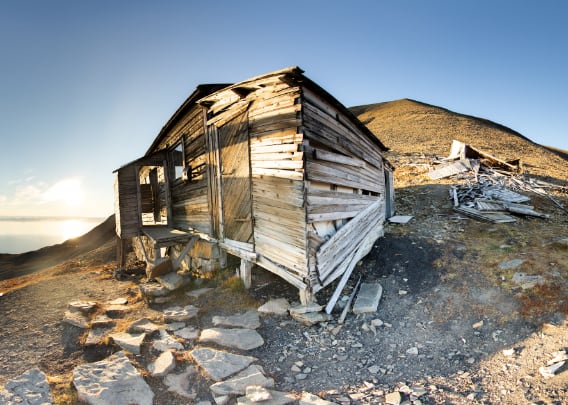
Since 2019, the sports club in Longyearbyen, Svalbard Turn, has been authorised by the Sysselmannen (now Sysselmester) to use the hut as a tour destination.
- pano anchor link: #a9p_Hiorthfjellet_23Aug14_696
In 2023/24, however, it turned out that the structural condition of the exhibition centre building no longer permitted its continued use, so that the Sysselmester withdrew the right of use from the sports club.
- pano anchor link: #a9p_Hiorthfjellet_23Aug14_732

It is likely that ‘Ørneredet’, the eagle’s nest, will now also fall into disrepair. It is not known that any conservation measures are planned.
- pano anchor link: #a9p_Hiorthfjellet_23Aug14_768

Which is very unfortunate, because the ‘Eagle’s Nest’ is truly unique. Not only because of its location at an altitude of around 580 metres with a magnificent view of the Adventfjord, Longyearbyen and the surrounding area, but also because it is part of one of the largest industrial monument complexes in Spitsbergen, together with the mine (‘Sneheim’) and Hiorthhamn, the village down by the Adventfjord.
- pano anchor link: #a9p_Hiorthfjellet_23Aug14_804
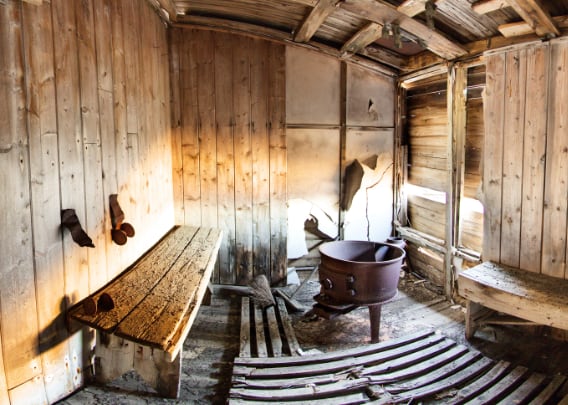
Photo gallery Ørneredet
Finally, a collection of photos with various impressions of ‘Ørneredet’, the Hiorthfjellgruve mess building / former accommodation area.
- gallery anchor link: #gallery_3459
Click on thumbnail to open an enlarged version of the specific photo.


BOOKS, CALENDAR, POSTCARDS AND MORE
This and other publishing products of the Spitsbergen publishing house in the Spitsbergen-Shop.
-

Norwegens arktischer Norden (1): Spitzbergen
Photobook: Norway's arctic islands. The text in this book is German. [shop url="https://shop.spitzbergen.de/en/polar-books/70-norwegens-arktischer-norden-1-aerial-arctic-9783937903262.html"] ← BackOrder now -
Norwegens arktischer Norden (2): Aerial Arctic
Lofoten, Jan Mayen and Spitsbergen from the air - Photobook: Norway's arctic islands. The text in this book is German, but there is very little text, so I am sure that you will enjoy it regardless which languages you read (or not).Order now -
Poster “Svalbardhytter”
The poster "Svalbardhytter" (70 x 100 cm) visualizes the diversity of Spitsbergen's huts in a range of arctic landscapes.Order now -
Book “Svalbardhytter”
The companion book for the Svalbardhytter poster. The poster visualises the diversity of Spitsbergen‘s huts and their stories in a range of Arctic landscapes. The book tells the stories of the huts in three languages.Order now -
Spitsbergen – Svalbard. The complete guidebook
Comprehensive guidebook about Spitsbergen. Background (wildlife, plants, geology, history etc.), practical information including travelling seasons, how to travel, description of settlements, routes and regions.Order now -
Rocks and Ice. Landscapes of the North
A geographical traveling accompaniment to Spitsbergen and East Greenland (68-74°N). This is the English edition of the German book "Steine und Eis".Order now -
East Greenland in Winter
Join an exciting journey with dog, skis and tent through the wintery wastes of East Greenland! We were five guys and a dog when we started in Ittoqqortoormiit, the northernmost one of two settlements on Greenland’s east coast.Order now -
Postcard set Spitsbergen (Svalbard)
12 Spitsbergen postcards in a beautifully designed tray. Individually numbered limited edition!Order now -
Limited edition postcard set Antarctica
12 postcards which come in a beautifully designed tray. Beautiful images from South Georgia across Antarctica from the Antarctic Peninsula to the Ross Sea and up to Macquarie Island and Campbell Island.Order now
last modification: 2025-01-17 ·
copyright: Rolf Stange


-
Books, Calendar, Postcards and more

-


