


-
current
recommendations- Liefdefjord
New page dedicated to one of Spitsbergen's most beautiful fjords. Background information and many photos.

- New Spitsbergen guidebook
The new edition of my Spitsbergen guidebook is out and available now!
- Liefdefjord
New page dedicated to one of Spitsbergen's most beautiful fjords. Background information and many photos.
-
weather information

| Guidebook: Spitsbergen-Svalbard |
Stormbukta
PanoTour
Stormbukta as a virtual panoramic tour
Here is a 360° tour with beautiful 360 degree shots of Stormbukta:
- pano anchor link: #Stormbukta
(1) Stormbukta
Stormbukta is far south on the west coast of Spitsbergen, between Hornsund and Spitsbergen’s south cape. It was named after a person and not after the strong winds that are often blowing here; the latter would actually have been equally appropriate. They say the most interesting places are often the most difficult ones to get to; Stormbukta is a good example for that. It is completely open to the often stormy north Atlantic in the west, and the shallows can make landing tricky. It is for good reason Sørkapp Land is not exactly amongst the most frequently visited parts of Spitsbergen.
(2) Stormbukta: Trollosen
But there is something special to Stormbukta, it is a unique place. Amongst others, there is Spitsbergen’s largest spring, called Trollosen (“troll spring”). It is actually a river coming out of a karst cave, pouring about 20 cubic metres of water per second over a short distance into the sea. The water flow owes its existance to the combination of water-soluble carbonate rocks and a geological fault, which probably initiated groundwater flow even in permafrost conditions. The wide glaciers of Sørkapp Land provide sufficient meltwater.
(3) Stormbukta: German war weather station “Landvik”
During World War II, the Nazis established secret weather stations in remote parts of the Arctic. In mid October 1944, a submarine transported 2 Norwegians complete with equipment to Stormbukta to provide the German air force with meteorological data used, for example, to plan attacks on allied convois. The station hut was built behind a little rock hill, not visible from the coast.
(4) Stormbukta: Kriegswetterstation “Landvik”
From early May 1945, the 2 Norwegians in German service sent their weather data not in coded form, but used clear text. They were not picked up before early August and had to serve 2 years in prison in Norway for having served for the German military secret service “Abwehr” in Stormbukta.
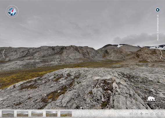
(5) Stormbukta
From an elevated position, the landscape features of Stormbukta become clear. Olsokbreen is visible in the south. Between the coastline and the coastal mountains, there is a stripe of flat land, as is typical for large parts of Spitsbergen’s west coast. The tundra there is mostly barren, but patches of lush green tundra indicate the presence of bird cliffs in the vicinity. Thousands of kittywakes are breeding on some steep cliffs in Stormbukta, an ideal home also for an arctic fox family.
All an all, Stormbukta has a lot of both typical Spitsbergen west coast characteristics and some unique features (the spring Trollosen, remains of the war weather station Landvik). Landing conditions are often dificult, if not impossible, and you can call yourself happy if you have been there.
BOOKS, CALENDAR, POSTCARDS AND MORE
This and other publishing products of the Spitsbergen publishing house in the Spitsbergen-Shop.
-

Norwegens arktischer Norden (1): Spitzbergen
Photobook: Norway's arctic islands. The text in this book is German. [shop url="https://shop.spitzbergen.de/en/polar-books/70-norwegens-arktischer-norden-1-aerial-arctic-9783937903262.html"] ← BackOrder now -
Norwegens arktischer Norden (2): Aerial Arctic
Lofoten, Jan Mayen and Spitsbergen from the air - Photobook: Norway's arctic islands. The text in this book is German, but there is very little text, so I am sure that you will enjoy it regardless which languages you read (or not).Order now -
Poster “Svalbardhytter”
The poster "Svalbardhytter" (70 x 100 cm) visualizes the diversity of Spitsbergen's huts in a range of arctic landscapes.Order now -
Book “Svalbardhytter”
The companion book for the Svalbardhytter poster. The poster visualises the diversity of Spitsbergen‘s huts and their stories in a range of Arctic landscapes. The book tells the stories of the huts in three languages.Order now -
Spitsbergen – Svalbard. The complete guidebook
Comprehensive guidebook about Spitsbergen. Background (wildlife, plants, geology, history etc.), practical information including travelling seasons, how to travel, description of settlements, routes and regions.Order now -
Rocks and Ice. Landscapes of the North
A geographical traveling accompaniment to Spitsbergen and East Greenland (68-74°N). This is the English edition of the German book "Steine und Eis".Order now -
East Greenland in Winter
Join an exciting journey with dog, skis and tent through the wintery wastes of East Greenland! We were five guys and a dog when we started in Ittoqqortoormiit, the northernmost one of two settlements on Greenland’s east coast.Order now -
Postcard set Spitsbergen (Svalbard)
12 Spitsbergen postcards in a beautifully designed tray. Individually numbered limited edition!Order now -
Limited edition postcard set Antarctica
12 postcards which come in a beautifully designed tray. Beautiful images from South Georgia across Antarctica from the Antarctic Peninsula to the Ross Sea and up to Macquarie Island and Campbell Island.Order now
last modification: 2019-05-09 ·
copyright: Rolf Stange


-
Books, Calendar, Postcards and more

-


