-
current
recommendations- Liefdefjord
New page dedicated to one of Spitsbergen's most beautiful fjords. Background information and many photos.

- New Spitsbergen guidebook
The new edition of my Spitsbergen guidebook is out and available now!

- Liefdefjord
New page dedicated to one of Spitsbergen's most beautiful fjords. Background information and many photos.
Page Structure
-
Spitsbergen-News
- Select Month
- June 2025
- May 2025
- April 2025
- March 2025
- February 2025
- January 2025
- December 2024
- November 2024
- October 2024
- September 2024
- August 2024
- July 2024
- June 2024
- May 2024
- April 2024
- March 2024
- February 2024
- January 2024
- December 2023
- November 2023
- October 2023
- September 2023
- August 2023
- July 2023
- June 2023
- May 2023
- April 2023
- March 2023
- February 2023
- January 2023
- December 2022
- November 2022
- October 2022
- September 2022
- August 2022
- July 2022
- June 2022
- May 2022
- April 2022
- March 2022
- February 2022
- January 2022
- December 2021
- November 2021
- October 2021
- September 2021
- August 2021
- July 2021
- June 2021
- May 2021
- April 2021
- March 2021
- February 2021
- January 2021
- December 2020
- November 2020
- October 2020
- September 2020
- August 2020
- July 2020
- June 2020
- May 2020
- April 2020
- March 2020
- February 2020
- January 2020
- December 2019
- November 2019
- October 2019
- September 2019
- August 2019
- July 2019
- June 2019
- May 2019
- April 2019
- March 2019
- February 2019
- January 2019
- December 2018
- November 2018
- October 2018
- September 2018
- August 2018
- July 2018
- June 2018
- May 2018
- April 2018
- March 2018
- February 2018
- January 2018
- December 2017
- November 2017
- October 2017
- September 2017
- August 2017
- July 2017
- June 2017
- May 2017
- April 2017
- March 2017
- February 2017
- January 2017
- December 2016
- November 2016
- October 2016
- September 2016
- August 2016
- July 2016
- June 2016
- May 2016
- April 2016
- March 2016
- February 2016
- January 2016
- December 2015
- November 2015
- October 2015
- September 2015
- August 2015
- July 2015
- June 2015
- May 2015
- April 2015
- March 2015
- February 2015
- January 2015
- December 2014
- November 2014
- October 2014
- September 2014
- August 2014
- July 2014
- June 2014
- May 2014
- April 2014
- March 2014
- February 2014
- January 2014
- December 2013
- November 2013
- October 2013
- September 2013
- August 2013
- July 2013
- June 2013
- May 2013
- April 2013
- March 2013
- February 2013
- January 2013
- December 2012
- November 2012
- October 2012
- September 2012
- August 2012
- July 2012
- June 2012
- May 2012
- April 2012
- March 2012
- February 2012
- January 2012
- December 2011
- November 2011
- October 2011
- September 2011
- August 2011
- May 2011
- April 2011
- March 2011
- February 2011
- January 2011
- December 2010
- November 2010
- September 2010
- August 2010
- July 2010
- June 2010
- May 2010
- April 2010
- March 2010
- February 2010
- November 2009
- October 2009
- August 2009
- July 2009
- June 2009
- May 2009
- April 2009
- March 2009
- February 2009
- January 2009
- December 2008
- November 2008
- October 2008
- August 2008
- July 2008
- June 2008
- May 2008
- April 2008
- March 2008
- February 2008
- April 2000
- Select Month
-
weather information
-
Newsletter

| Guidebook: Spitsbergen-Svalbard |
Home
→ * Photos, Panoramas, Videos and Webcams
→ Spitsbergen Panoramas
→ Blomsterdalshøgda: Trøndergruva
Blomsterdalshøgda: Trøndergruva
Mountain hike and mining history near Longyearbyen
Blomsterdalen is a little valley on the north slope of Platåberg near Longyearbyen, behind the airport.
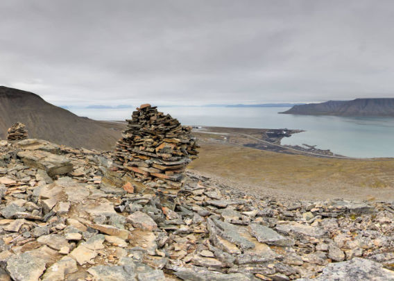
Pano 1: Blomsterdalshøgda, view into Blomsterdalen
This group of cairns, situated in about 200 metres altitude, is easy to reach and has a fine view over Adventfjord. A nice destination of an easy little mountain hike. From this side of the ridge, we have the view into Blomsterdalen which is coming down from Platåberg.
- pano anchor link: #200723_Blomsterdalshogda_058
Blomsterdalshøgda, the “Flower valley height”
Blomsterdalshøgda translates as “Flower valley height”, and indeed, there are various flowers here and there. We spent some time fiddling with the cameras, trying to get good images of the flowers by using the focus stacking technique. This involves a series of photos, each one taken with a slightly different focus, and then combining the photos later to an image with increased depth of field.
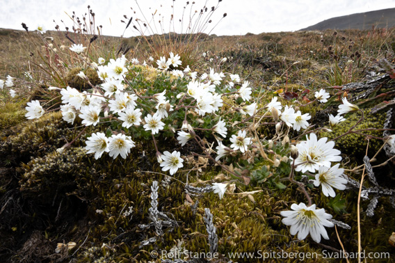
Arctic mouse ear chickweed (Cerastium arcticum) on Blomsterdalshøgda.
This image was made with the focus stacking technique to increase the depth of field (compare to the conventional photo below).
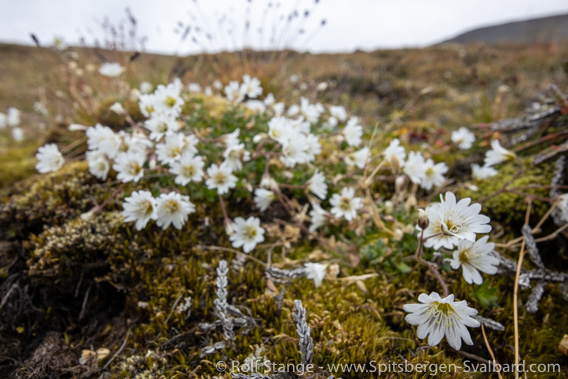
Arctic mouse ear chickweed on Blomsterdalshøgda. Conventional photo with much less depth of field than the image above with is made with the focus stacking method.
Blomsterdalshøgda: mountain walk and mining history near Longyearbyen
Blomsterdalshøgda is a ridge on the east side of Blomsterdalen. If you start walking from the road to the airport, where the way to Mine 3/SvalSat branches off, then the higher part of the ridge can easily be reached within an hour. It is certainly not a big full day hike and not the most exciting mountain walk in the vicinity of Longyearbyen, but that doesn’t mean that it does not have anything to offer.
Pano 2: Blomsterdalshøgda, view over Adventfjord
Close to the location of panorama 1, but a few metres over to the other side of the ridge so we have the view over Adventfjord, with the airport and the camping place and Longyearbyen and Adventdalen.
- pano anchor link: #200723_Blomsterdalshogda_039
But there is one particular aspect that makes Blomsterdalshøgda unique, especially for those interested in the mining history of Spitsbergen. In about 250 m altitude, there is an old mine entrance. Before I forget to mention it: old coal mines are life dangerous and should absolutely not be entered, not just because of the danger of falling rocks, but also – mainly – because of gas that may leak out from the coal seam.
This mine may be unimpressive at a quick glance, but it is one of Spitsbergen’s oldest coal mines and it was the very first one in the Longyearbyen area. This is where it all started! 🙂
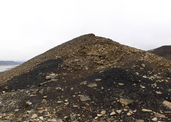
Pano 3: Trøndergruva
A couple of metres below the actual mine entrance.
- pano anchor link: #200723_Blomsterdalshogda_001
Early coal mining in Spitsbergen: Bohemanneset and Adventfjord
The first attempt to mine coal for commercial purposes is usually associated with Søren Zachariassen who extracted 600 hl of coal at Bohemanneset, which you can actually see across the fjord from Blomsterdalshøgda. But that was a short-lived enterprise, it was abandoned after just one season.
Only two years later, another attempt was made in Adventfjord, and this attempt was to be more long-living. In 1901, a company from Bergen in Norway started trial mining at Adventfjellet (today known as Adventtoppen), on the north side of Adventfjord, opposite the airport. No more than 5 tons of coal were extracted. The work at Adventfjellet was continued in 1903 and a mine called Advent City was operated at this site from 1904 to 1908 by an English-Norwegian mining company.
Henrik Næss and the Trondhjem-Spitsbergen Kulkompani
Meanwhile, word was spreading in Norway that mining in Spitsbergen might be the next big thing. Skipper Henrik Næss from Trondheim sent a couple of people to occupy “any coal field” that might be available. The group settled at Hotellneset, not far from where the airport is today, and investigated the coal occurrence on the north slope of Platåberg in the area of Blomsterdalen. The results were found promising and Næss founded the Trondhjem-Spitsbergen Kulkompani. The little mine that was established on Blomsterdalshøgda is now known as Trøndergruva, after the part of Norway where Trondheim is located.

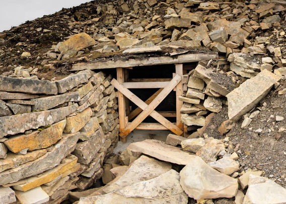
View into Trøndergruva on Blomsterdalshøgda.
Pano 4: Trøndergruva
The entrance of Trøndergruva: the first coal mine in the area of Longyearbyen.
- pano anchor link: #200723_Blomsterdalshogda_020
John Munro Longyear and the Arctic Coal Company
The American John Munro Longyear had visited Spitsbergen for the first time 1901 as a cruise ship passenger. He got samples of the coal at Platåberg, founded the Arctic Coal Company and bought the coal field from the Trondhjem-Spitsbergen Kulkompani. In 1906, Longyear went ahead with his Arctic Coal Company and started mining in Adventfjord. For his new mining settlement, he did not use Hotellneset near Blomsterdalen, but the valley on the east side of the mountain, today known as Longyeardalen. The rest is history.
BOOKS, CALENDAR, POSTCARDS AND MORE
This and other publishing products of the Spitsbergen publishing house in the Spitsbergen-Shop.
last modification: 2021-05-19 ·
copyright: Rolf Stange

