


-
current
recommendations- Liefdefjord
New page dedicated to one of Spitsbergen's most beautiful fjords. Background information and many photos.

- New Spitsbergen guidebook
The new edition of my Spitsbergen guidebook is out and available now!
- Liefdefjord
New page dedicated to one of Spitsbergen's most beautiful fjords. Background information and many photos.
-
weather information

| Guidebook: Spitsbergen-Svalbard |
Alkefjellet
360° panorama
Alkefjellet ist one of the great natural wonders of Spitsbergen and beyond. For me, it is one of the big places on Earth. Just the cliffs, vertical basalt rocks up to more than 100 m high, are worth seeing, but the obvious main attraction are many tenthousands of Brünich’s guillemots breeding here, turning Alkefjellet into a place which is just exploding with life like few other ones on the planet (Gold Harbour and St. Andrew’s Bay on South Georgia come to my mind). Sometimes a polar fox or even a polar bear is seen climbing on those parts of the cliff which are less steep, looking for eggs or chicks that fell down from the nest.
- pano anchor link: #180811b_Kinnvika_53HDR
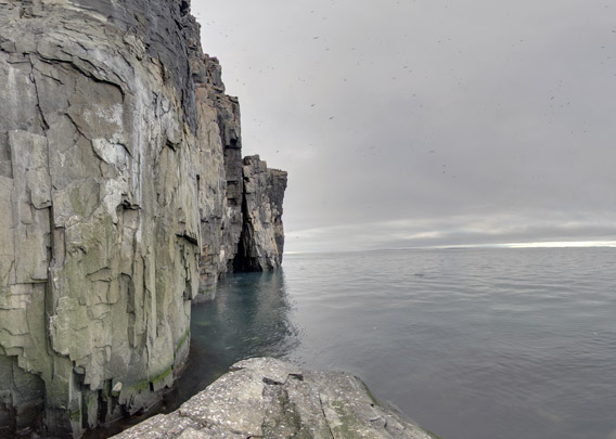
How to photograph a place like this? This is a good question. I have been many times to Alkefjellet and I have tried in many different ways, but without results that I’d be 100 % happy with. Of course you can catch a total view of the mighty cliff, aim at a large number of birds in one frame or capture individual birds sitting on a ledge or even in flight (quite a challenge to get a sharp photo of a Brünich’s guillemot in flight). But whatever you photograph, it is always just one facet of a place that is so overwhelming in all aspects. Not to mention the sounds and the smell. You just have to experience Alkefjellet yourself!
Of course, trying to panorama-photograph Alkefjellet had been a temptation for some time. But how to do with a vertical cliff that is rising up straight from the sea, where do you put the tripod up solid? A second-class freehand solution was not really an option for me.

The first attempt to reach a low terrace that was not occupied by birds failed. The photo (thanks to Pål Remen for the photo and to Monika for driving the Zodiac!) may look heroic, but, well, at least I did not fall into the water.
A bit further on, there was another, lower rock, just big enough for me and the triplod 🙂
BOOKS, CALENDAR, POSTCARDS AND MORE
This and other publishing products of the Spitsbergen publishing house in the Spitsbergen-Shop.
-

Norwegens arktischer Norden (1): Spitzbergen
Photobook: Norway's arctic islands. The text in this book is German. [shop url="https://shop.spitzbergen.de/en/polar-books/70-norwegens-arktischer-norden-1-aerial-arctic-9783937903262.html"] ← BackOrder now -
Norwegens arktischer Norden (2): Aerial Arctic
Lofoten, Jan Mayen and Spitsbergen from the air - Photobook: Norway's arctic islands. The text in this book is German, but there is very little text, so I am sure that you will enjoy it regardless which languages you read (or not).Order now -
Poster “Svalbardhytter”
The poster "Svalbardhytter" (70 x 100 cm) visualizes the diversity of Spitsbergen's huts in a range of arctic landscapes.Order now -
Book “Svalbardhytter”
The companion book for the Svalbardhytter poster. The poster visualises the diversity of Spitsbergen‘s huts and their stories in a range of Arctic landscapes. The book tells the stories of the huts in three languages.Order now -
Spitsbergen – Svalbard. The complete guidebook
Comprehensive guidebook about Spitsbergen. Background (wildlife, plants, geology, history etc.), practical information including travelling seasons, how to travel, description of settlements, routes and regions.Order now -
Rocks and Ice. Landscapes of the North
A geographical traveling accompaniment to Spitsbergen and East Greenland (68-74°N). This is the English edition of the German book "Steine und Eis".Order now -
East Greenland in Winter
Join an exciting journey with dog, skis and tent through the wintery wastes of East Greenland! We were five guys and a dog when we started in Ittoqqortoormiit, the northernmost one of two settlements on Greenland’s east coast.Order now -
Postcard set Spitsbergen (Svalbard)
12 Spitsbergen postcards in a beautifully designed tray. Individually numbered limited edition!Order now -
Limited edition postcard set Antarctica
12 postcards which come in a beautifully designed tray. Beautiful images from South Georgia across Antarctica from the Antarctic Peninsula to the Ross Sea and up to Macquarie Island and Campbell Island.Order now
last modification: 2019-01-18 ·
copyright: Rolf Stange


-
Books, Calendar, Postcards and more

-


