


-
current
recommendations- Liefdefjord
New page dedicated to one of Spitsbergen's most beautiful fjords. Background information and many photos.

- New Spitsbergen guidebook
The new edition of my Spitsbergen guidebook is out and available now!

- Liefdefjord
New page dedicated to one of Spitsbergen's most beautiful fjords. Background information and many photos.
-
weather information

| Guidebook: Spitsbergen-Svalbard |
Home → Spitsbergen information → Islands: Spitsbergen & Co. → Spitsbergen (Northern part) → Sorgfjord
Sorgfjord
Nature and history of a fjord in northeast Spitsbergen
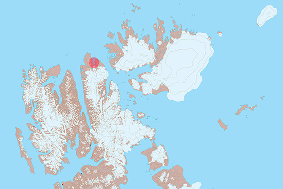
Sorgfjord is located on the northeast corner of Spitsbergen.
General
Situated just under 80°N at the northeastern corner of Spitsbergen at the entrance to the Hinlopen Strait, Sorgfjord is a scenic little fjord with a lot of interesting history. In historical times, Sorgfjord was also called ‘Treurenburg Bai’. The scenery may not be as spectacular as in some other fjords – there are no glaciers reaching the sea with calving cliffs, and the mountains are low, plateau-shaped, but it is characteristic and beautiful in its very own way and there are good hiking opportunities.
Sorgfjord-Panorama
There are several pages on this website dedicated to individual sites in Sorgfjord. These pages have background information, photo galleries and 360-dergree-panoramas.
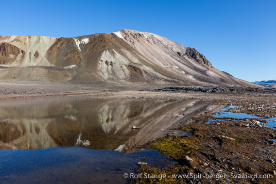
Geology
Upper Precambrian, non-metamorphic sediments such as quarzites and dolomites, tectonically deformed and mostly steeply dipping. The same rocks are found further south in Lomfjord, in northeastern Hinlopen Strait and on Lågøya.
The mountain Heclahuken on the east side of Sorgfjord.
For those with some special interest in some of the finer details of geology, Sorgfjord has some interesting sites to offer. If you have, for example, ever wondered about the difference between layering and cleavage, then the rocks in the image below, found on the south side of Crozierpynten, may illustrate that very well. In this picture, you see both layering and cleavage. Layering (in the photo horizontal) originates during deposition of the sediment, while cleavage comes from tectonic pressure. Cleavage is always younger than layering (you can’t squeeze anything that isn’t there yet). In the photo, cleavage runs through the rocks from the lower left to the upper right.

Steeply dipping upper Precambrian sediments (light-grey quarzitic sandstone and dark silt- and claystone) on the eastern side of the Sorgfjord (Crozierpynten).
Recommended book for further, well-digestable (really!) info about geology and landscape of Svalbard.
Landscape
Low plateau-shaped mountains with wide coastal plains, on which there are well-developed series of beach ridges. The interiour south of Sorgfjord is strongly glaciated.
Sorgfjord is a beautiful area for hiking. The northern part of Magdalenafjellet can be reached relatively easily with a bit of stamina and sure-footedness.
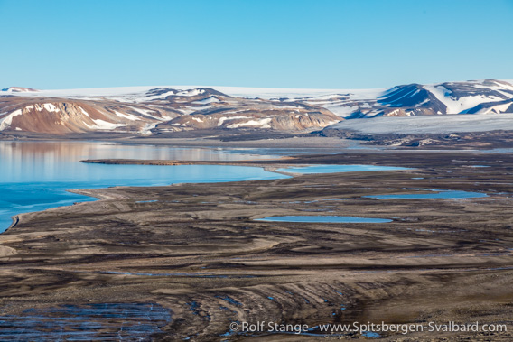
View from Magdalenafjellet over the lowland in inner Sorgfjord.
Flora and Fauna
Sorgfjord appears to be quite barren, a polar desert environment. This bay is usually not an outstanding wildlife site. Occasionally reindeer, and the mountains are, as can be expected, good places to find ptarmigan. The frequency of walrus sightings has increased in recent years, a very positive sign of the comeback of this species after it had been hunted almost to regional extinction until the 1950s. Migratory wildlife is, of course, always possible, and that may well including polar bears.
History
Considering it is a relatively small fjord, there is an amazing lot of stories connected to the place. The name ‘Sorgfjord’ (Worry bay) goes back to the whalers and may refer to difficulties with the ice in this corner of Spitsbergen, where the Gulf Stream is loosing its influence. It could also refer to armed conflicts between different whaling nations: In 1693, the Sorgfjord saw the northernmost sea battle ever when thee French warships brought up 40 Dutch whaling ships. 13 Dutch ships were captured, the rest escaped. A little graveyard at Eolusneset on the western side of Sorgfjord reminds us of the dangers of a whaler’s life. It was used by whalers in the 17th and 18th centuries, certainly including Dutch whalers, possibly also from other countries.
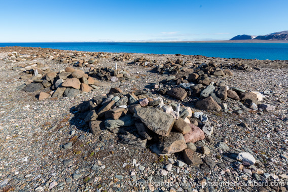
Whalers’ graveyard at Eolusneset.
In 1827, the Englishman William Edward Parry anchored on the east side of Sorgfjord with his ship Hecla. The bay, located directly south of Crozierpynten, has since been known as Heclahamna (Hecla harbor).
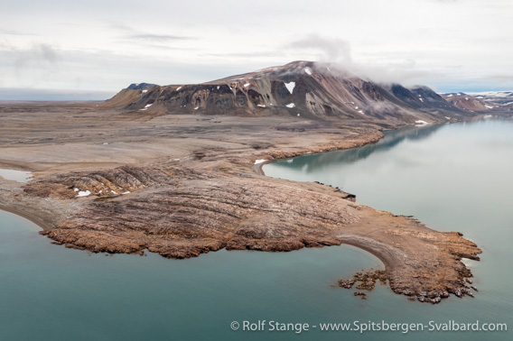
The little headland of Crozierpynten with Heclahamna on the southern (right) side.
The hill Flaggstanghaugen on Crozierpynten is just 31 meters high. Sometimes this is more than enough for a great view. Heclahamna is on the southern side of Crozierpynten.
Parry tried to reach the north pole with specially constructed sledge boats that could both be rowed in open water and pulled over ice, but he had to turn around at 82°40’N due to the difficulties the ice provided and the current which was against him and his men. The discovery of this NW-SE going current was, at least, a very significant one. As a consequence, Spitsbergen was mostly ignored by following expeditions aiming for the north pole, who favoured arctic Canada and northern Greenland instead for their bases.
There is a peculiar cross on a low hill at Eolusneset, known as Eoluskorset (Eolus cross. It was erected on June 06, 1855, by skipper J. Holmgren, Captain of the schooner Æolus (other spelling: Eolus) from Bergen. The ship was trapped in ice for some weeks, and in such cases it is of course always good to build a cross – you never know. In 1861, Æolus was there again, with the know famous Swedish polar explorer and geologist Otto Torell on board.
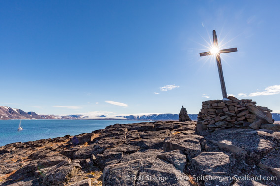
Eoluskorset / the Eolus cross at Eolusneset.
The Swedish-Russian Arc-de-Meridian Expedition (1899-1904) used the eastern side of the Sorgfjord (Heclahamna/Crozierpynten) for one of their headquarters.
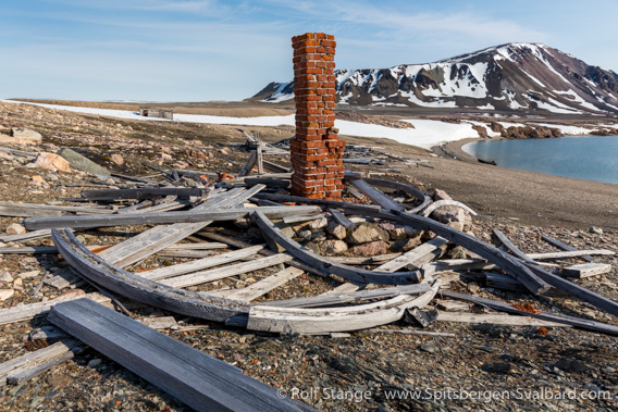
Remains of the station of the Arc-de-Meridian-expedition at Crozierpynten.
The list of those who visited Crozierpynten in the 19th and early 20th century is almost a who-is-who of arctic exploration of those years … the above-mentioned Edward Parry (1827), the Swedish section of the Russian-Swedish Arc-de-meridian-expedition established their wintering quarters there in 1899, and the Herzog Ernst, ship of the Schröder-Stranz-expedition, was forced to spend the winter 1912-13 there, while the leader himself, Herbert Schröder-Stranz, was most likely already dead on Nordaustland. This list is anything but complete. Not to mention all the trappers who wintered there when the Swedish house was still standing upright.
The station of the Arc-de-Meridian expedition on the southern side of Crozierpynten was built in 1899 by the Swedish section of the above-mentioned expedition and subsequently used to winter there. The expedition is surprisingly little known, but it was very successful and brought a wealth of topographic and other scientific material back home without any loss of life, quite in contrast to many others in those early years.
Later, Sorgfjord was the pivotal point for the ill-fated Schröder-Stranz-Expedition.
Trappers did not winter too often in Sorgfjord. They preferred Wijdefjord, the neighbouring fjord further west, which was easier to reach and provided better hunting opportunities. It was easier to get home again early in the summer after a wintering from Wijdefjord than from Sorgfjord, where the drift ice would often block the passage around Verlegenhuken from quite some time into the summer. There is still the ruin of a trapper hut on the north side of Eolusneset, but it has never been more than a small, secondary hut used occasionally on hunting trips from the main territory further west, in northern Wijdefjord.
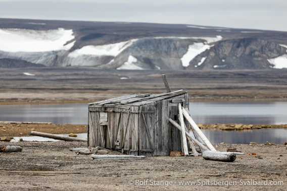
Ruin of a trapper hut at Eolusneset.
Photo gallery – Sorgfjord
Some impressions from the years 2007-2023. There are more photo gallery in the pages dedicated to Crozierpynten, Eolusneset and Magdalenafjellet.
- gallery anchor link: #gallery_2943
Click on thumbnail to open an enlarged version of the specific photo.


BOOKS, CALENDAR, POSTCARDS AND MORE
This and other publishing products of the Spitsbergen publishing house in the Spitsbergen-Shop.
-

Norwegens arktischer Norden (1): Spitzbergen
Photobook: Norway's arctic islands. The text in this book is German. [shop url="https://shop.spitzbergen.de/en/polar-books/70-norwegens-arktischer-norden-1-aerial-arctic-9783937903262.html"] ← BackOrder now -
Norwegens arktischer Norden (2): Aerial Arctic
Lofoten, Jan Mayen and Spitsbergen from the air - Photobook: Norway's arctic islands. The text in this book is German, but there is very little text, so I am sure that you will enjoy it regardless which languages you read (or not).Order now -
Poster “Svalbardhytter”
The poster "Svalbardhytter" (70 x 100 cm) visualizes the diversity of Spitsbergen's huts in a range of arctic landscapes.Order now -
Book “Svalbardhytter”
The companion book for the Svalbardhytter poster. The poster visualises the diversity of Spitsbergen‘s huts and their stories in a range of Arctic landscapes. The book tells the stories of the huts in three languages.Order now -
Spitsbergen – Svalbard. The complete guidebook
Comprehensive guidebook about Spitsbergen. Background (wildlife, plants, geology, history etc.), practical information including travelling seasons, how to travel, description of settlements, routes and regions.Order now -
Rocks and Ice. Landscapes of the North
A geographical traveling accompaniment to Spitsbergen and East Greenland (68-74°N). This is the English edition of the German book "Steine und Eis".Order now -
East Greenland in Winter
Join an exciting journey with dog, skis and tent through the wintery wastes of East Greenland! We were five guys and a dog when we started in Ittoqqortoormiit, the northernmost one of two settlements on Greenland’s east coast.Order now -
Postcard set Spitsbergen (Svalbard)
12 Spitsbergen postcards in a beautifully designed tray. Individually numbered limited edition!Order now -
Limited edition postcard set Antarctica
12 postcards which come in a beautifully designed tray. Beautiful images from South Georgia across Antarctica from the Antarctic Peninsula to the Ross Sea and up to Macquarie Island and Campbell Island.Order now
last modification: 2023-10-15 ·
copyright: Rolf Stange
-
Books, Calendar, Postcards and more

-


