-
current
recommendations- Liefdefjord
New page dedicated to one of Spitsbergen's most beautiful fjords. Background information and many photos.
- New Spitsbergen guidebook
The new edition of my Spitsbergen guidebook is out and available now!
- Liefdefjord
New page dedicated to one of Spitsbergen's most beautiful fjords. Background information and many photos.
Page Structure
-
Spitsbergen-News
- Select Month
- May 2025
- April 2025
- March 2025
- February 2025
- January 2025
- December 2024
- November 2024
- October 2024
- September 2024
- August 2024
- July 2024
- June 2024
- May 2024
- April 2024
- March 2024
- February 2024
- January 2024
- December 2023
- November 2023
- October 2023
- September 2023
- August 2023
- July 2023
- June 2023
- May 2023
- April 2023
- March 2023
- February 2023
- January 2023
- December 2022
- November 2022
- October 2022
- September 2022
- August 2022
- July 2022
- June 2022
- May 2022
- April 2022
- March 2022
- February 2022
- January 2022
- December 2021
- November 2021
- October 2021
- September 2021
- August 2021
- July 2021
- June 2021
- May 2021
- April 2021
- March 2021
- February 2021
- January 2021
- December 2020
- November 2020
- October 2020
- September 2020
- August 2020
- July 2020
- June 2020
- May 2020
- April 2020
- March 2020
- February 2020
- January 2020
- December 2019
- November 2019
- October 2019
- September 2019
- August 2019
- July 2019
- June 2019
- May 2019
- April 2019
- March 2019
- February 2019
- January 2019
- December 2018
- November 2018
- October 2018
- September 2018
- August 2018
- July 2018
- June 2018
- May 2018
- April 2018
- March 2018
- February 2018
- January 2018
- December 2017
- November 2017
- October 2017
- September 2017
- August 2017
- July 2017
- June 2017
- May 2017
- April 2017
- March 2017
- February 2017
- January 2017
- December 2016
- November 2016
- October 2016
- September 2016
- August 2016
- July 2016
- June 2016
- May 2016
- April 2016
- March 2016
- February 2016
- January 2016
- December 2015
- November 2015
- October 2015
- September 2015
- August 2015
- July 2015
- June 2015
- May 2015
- April 2015
- March 2015
- February 2015
- January 2015
- December 2014
- November 2014
- October 2014
- September 2014
- August 2014
- July 2014
- June 2014
- May 2014
- April 2014
- March 2014
- February 2014
- January 2014
- December 2013
- November 2013
- October 2013
- September 2013
- August 2013
- July 2013
- June 2013
- May 2013
- April 2013
- March 2013
- February 2013
- January 2013
- December 2012
- November 2012
- October 2012
- September 2012
- August 2012
- July 2012
- June 2012
- May 2012
- April 2012
- March 2012
- February 2012
- January 2012
- December 2011
- November 2011
- October 2011
- September 2011
- August 2011
- May 2011
- April 2011
- March 2011
- February 2011
- January 2011
- December 2010
- November 2010
- September 2010
- August 2010
- July 2010
- June 2010
- May 2010
- April 2010
- March 2010
- February 2010
- November 2009
- October 2009
- August 2009
- July 2009
- June 2009
- May 2009
- April 2009
- March 2009
- February 2009
- January 2009
- December 2008
- November 2008
- October 2008
- August 2008
- July 2008
- June 2008
- May 2008
- April 2008
- March 2008
- February 2008
- April 2000
- Select Month
-
weather information
-
Newsletter

| Guidebook: Spitsbergen-Svalbard |
Longyearbyen
360°-Panoramas
On this page you can use the map below or the links further down to click your way through Longyearbyen for a little virtual tour, or you can read a bit about the natural and human history further down on this page. This page does not replace the tourist information and certainly not the guidebook “Spitsbergen-Svalbard” 🙂
Map Longyearbyen
The panoramas in detail
- Longyearbyen centre (city centre, coal miner’s monument)
- Longyearbyen: coal cableway
- Longyearbyen: Coal cableway at Burmaveien
- Longyearbyen: lower part
- Longyearbyen: Nye gruve 2
- Longyearbyen: Old coal cableway: curve station Skjæringa
- Longyearbyen: Santa Claus letter box
- Longyearbyen: Svalbardmuseum
- Longyearbyen: Taubanesentrale (Coal cableway centre)
General
The Adventfjord area is the most densely populated part of Svalbard. Longyearbyen is residence of the Norwegian administration (Sysselmester = Gouvernour), services and infrastructure (airport, port, hospital, shops, hotels etc), science (Polar institute, university, museum etc.), tour operators. The area has a lot to offer for everybody interested not only in history and today’s settlements, but also in landscape, flora and fauna.
There are some rules regarding protection of nature, cultural heritage and tourists and to make tourism tolerable for everybody, also near and in the settlements. Click here for more information.

Longyearbyen.
Geology
This section may require some dedication to the matter 🙂
Lower Cretaceous and lower Tertiary (upper Cretaceous is missing in Svalbard). Mostly undeformed sediments, gently dipping to south. Because of this, the slopes on the northern side of the Adventfjord are mostly Cretaceous except from the highest parts. The Cretaceous Festningen-Sandstone is a prominent layer of quartzitic sandstone, which often forms protruding cliffs due to its relative hardness. This is nicely visible on the northern side of the Adventfjord, where there are two cliff-building, hard layers in the higher slopes. The lower one is the Festningen sandstone, the upper one a similar layer of lower Tertiary sandstone (‘Firkanten Formation’).
Both Cretaceous and Tertiary consist lithologically of shallow marine and coastal sand-, silt- and claystones. The sandstones are derived from deltaic sediments, the claystones point to stronger marine influence in a larger distance from the coast. Obviously, there were several transgressional/regressional cycles (relativ sea-level rise and fall). This becomes nicely clear during a daytrip on the Nordenskiöldtoppen, a mountain more than 1000 metres high near Longyearbyen towering above Platåfjellet. Here, dark claystones alternate with silt- and sandstone. The claystones represent phases of higher sea level, when the coast was far away and only fine grains were deposited here. When the coast got nearer again due to a relative drop of sea level, sand was deposited which was washed into the sea by rivers. Some of the sandstone layers are very fossil-rich, leaves similar to those of nazelnut trees are very common there (check the morains of the glaciers which bring everything together or, which is easier, the museum in Longyearbyen).
Both Cretaceous and Tertiary are coal-bearing. The hard coal was mined during the 20th century on both sides of the fjord (see below).

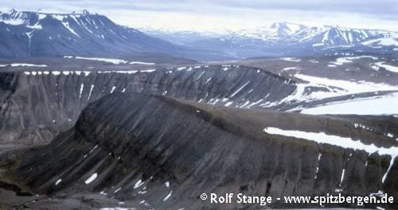
Horizontal layers of sediment (sandstone, siltstone) from the lower Tertiary. Fuglefjellet, west of Longyearbyen.
Recommended book for further, well-digestable (really!) info about geology and landscape of Svalbard.
Landscape
Most striking, at least in comparison with other parts of Svalbard, is the dense land-use, but this does not mean that nature does not have anything to offer here. The landscape is characterised by the plateau-shaped mountains which are so typical for central and eastern Svalbard, with high plateaus 400-500 metres above sea level. The plateaus are wide stone-deserts, partly with frost-patterned ground and largely free of vegetation.
Most rocks above this level have been eroded – in other words, they have been there at some time. But now, only a few mountains tower higher than the plateau such as the Nordenskiöld-Toppen and Trollsteinen near Longyearbyen. Here, one can still see what kind of rocks once covered the whole area, but the highest (youngest) ones are still lower Tertiary. Around Longyearbyen, the lower Tertiary sandstone of the ‘Firkanten Formation’ forms conspicuous cliffs which are cut into regular, spectacular towers by erosion. The slopes are mostly covered with scree (rocks with mostly sharp edges, from frost shatter). Compared to other regions within Svalbard, Adventfjord and Longyeardalen may appear to be a bit grey-brown in colour with little contrast, which is due to the colour of the rocks, and there are only few and relatively small glaciers.

Plateau in an elevation of 4-500 metres near Longyearbyen (in the foreground the mountain Sarkofagen, Longyearbyen to the left just outside the photo. Adventdalen in the background).
Flora and Fauna
Both are surprisingly rich, despite of the presence of more than 1500 humans. There is nice tundra in Bjørndalen and on the lower slopes between there and Longyearbyen as well as in Adventdalen. There, you may even find the polar birch, which is rare in Svalbard – good luck 🙂 Near Longyearbyen, there are small colonies of Little auks nesting on the higher slopes. They breed under boulders, so you don’t see them nesting, but you see the birds flying in and out and sitting on rocks. If you want to see Arctic terns, Kittiwakes, Snow Bunting and, with some luck, even Red phalaropes, then the camping site near the airport and the artificial lagoon between the camping site and the coast is a good place to visit (keep your distance from breeding birds, don’t disturb them, see rules). In the Adventdalen, you may see King Eider near some small ponds if you know where to look for them and you need some luck, too. The elusive Ivory gull may be seen near the dogyard just outside Longyearbyen in the Adventdalen. It is not too unusual to see fox and reindeer even in the centre of Longyearbyen.
All in all – near Longyearbyen, you can see quite a lot of arctic flora and fauna. You can spend several days here, if you know where to look – consider to you hire your own guide, for a number of interesting places, you will also need a rifle, transportation etc.
History
Longyearbyen would not exist without mining. American John Munro Longyear saw the coal seams during a cruise and founded the Arctic Coal Company Ltd. Mining in ‘Advent Bay’ started in 1906. Longyear sold everything to the Norwegian ‘Store Norske Spitsbergen Kullkompani’ (SNSK) in 1916 because of the development of the global markets as well as local difficulties. The SNSK, now state-owned, still exists under the name ‘Store Norske’ (Great Norwegian) and is the landowner in Longyearbyen. Mining has been reduced to a more symbolic level in mine 7 in nearby Adventdalen. The centre of Norwegian coal-mining is Sveagruva.
During, the war, there have been fights in Spitsbergen on several occasions. Most settlements, including Longyearbyen, were destroyed.
Life on Svalbard changed significantly when the airport was opened in 1975.
Tourism has also a long history in the area. A hotel was even opened in 1896 at Hotellneset (which explains the name). It was, however, already closed again in 1898. Today, you find the camp site in the vicinity (a bit further west), there are no remains of the old hotel which was taken to Longyearbyen for other use and destroyed during a German attack in 1943.

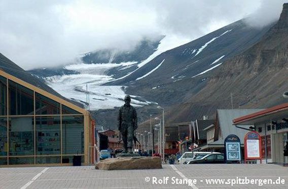
Longyearbyen ‘downtown’ with supermarket (left) and glacier (background).
BOOKS, CALENDAR, POSTCARDS AND MORE
This and other publishing products of the Spitsbergen publishing house in the Spitsbergen-Shop.
last modification: 2025-03-20 ·
copyright: Rolf Stange


