-
current
recommendations- Liefdefjord
New page dedicated to one of Spitsbergen's most beautiful fjords. Background information and many photos.

- New Spitsbergen guidebook
The new edition of my Spitsbergen guidebook is out and available now!
- Liefdefjord
New page dedicated to one of Spitsbergen's most beautiful fjords. Background information and many photos.
-
weather information

| Guidebook: Spitsbergen-Svalbard |
Home →
Daily Archives: 2. January 2015 − News & Stories
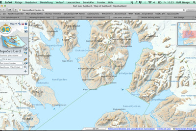
Digital map Spitsbergen
The new year (happy new year to all visitors of this website, by the way!) has a good start, with a slightly delayed Christmas present from the Norwegian government: as announced, the Norwegian Polar Institute has made the digital maps from the Arctic and Antarctic available as downloads. So far, the nice digital maps from Spitsbergen, Jan Mayen and the Antarctic (Peter I Island, Dronning Maud Land) could only be viewed online. Now, they can be downloaded in pixed-based and vector file formats and used under “Creative Commons Attribution 4.0 International (CC BY 4.0) License”. This means the maps can now be used offline in the field and by authors, website owners and others for publications and this will make some people happy, including the present owner.
More on the Norwegian Polar Institute website (Norwegian).
To get to the download site, click here.
TopoSvalbard, the digital Spitsbergen map. Now, the map data can be downloaded for offline use. © Norwegian Polar Institute.
News-Listing live generated at 2025/May/11 at 12:27:36 Uhr (GMT+1)


-
Books, Calendar, Postcards and more

-


